
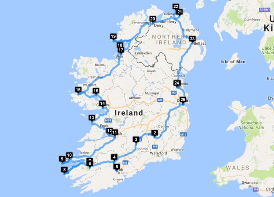
Length: 10 days (8 in Ireland, 2 in Northern Ireland)
Tour Company: Over the Horizon
Tour: Ireland and Northern Ireland Self Guided
Traveler: Dave
Places visited:
1 – Dublin, Ireland (See Ireland – August 2017)
2 – Kilkenny, Ireland (See Ireland – August 2017)
3 – Cashel, Ireland (See Ireland – August 2017)
4 – Mallow, Ireland (See Ireland – August 2017)
5 – Blarney, Ireland (See Ireland – August 2017)
6 – Torc Waterfall, Ireland (See Ireland – August 2017)
7 – Killarney, Ireland (See Ireland – August 2017)
8 – Kerry Cliffs, Ireland (See Ireland – August 2017)
9 – Cross at Slea Head, Ireland (See Ireland – August 2017)
10 – Connor’s Pass, Ireland (See Ireland – August 2017)
11 – Limmerick, Ireland (See Ireland – August 2017)
12 – Bunratty Castle, Ireland (See Ireland – August 2017)
13 – Cliffs of Moher, Ireland (See Ireland – August 2017)
14 – Galway, Ireland (See Ireland – August 2017)
15 – Ashford Castle, Ireland (See Ireland – August 2017)
16 – Connemara National Park, Ireland (See Ireland – August 2017)
17 – Gelniff Horseshoe, Ireland (See Ireland – August 2017)
18 – Mullaghmore Beach, Ireland (See Ireland – August 2017)
19 – Slieve League, Ireland (See Ireland – August 2017)
20 – Londonderry, UK
21 – The Dark Hedges, UK
22 – Giant’s Causeway, UK
23 – Belfast, UK
24 – Newgrange, Ireland (See Ireland – August 2017)
25 – Brú na Bóinne, Ireland (See Ireland – August 2017)
26 – Dublin, Ireland (See Ireland – August 2017)
Continuing the road trip from Ireland, I left the Willow Cottage Donegal B&B and drove 1.5 hrs to Northern Ireland. My plan for Northern Ireland was to visit Londonderry (Derry), The Dark Hedges, Giant’s Causeway, and Belfast before returning to Ireland.
Northern Ireland was created in 1921, when Ireland was partitioned between Northern Ireland and Southern Ireland by the Government of Ireland Act of 1920. Unlike Southern Ireland, which would become the Irish Free State in 1922, the majority of Northern Ireland’s population were unionists, who wanted to remain within the United Kingdom. Most of these were the Protestant descendants of colonists from Great Britain. However, a significant minority, mostly Catholics, were nationalists who wanted a united Ireland, independent of British rule. Today, the Protestants generally see themselves as British and the Catholics generally see themselves as Irish, while a distinct Northern Irish, or Ulster, identity is claimed both by a large minority of Catholics and Protestants and by many of those who are non-aligned.
For most of the 20th century, Northern Ireland was marked by discrimination and hostility between these two sides in what First Minister of Northern Ireland David Trimble called a “cold house” for Catholics. In the late 1960s, conflict between state forces and primarily Protestant unionists on one side, and primarily Catholic nationalists on the other, erupted into three decades of violence known as “The Troubles”, which claimed over 3,500 lives and over 50,000 were injured. The 1998 Good Friday Agreement was a major step in the peace process, although sectarianism and religious segregation still remain major social problems, and sporadic violence has continued.
Northern Ireland has historically been the most industrialized region of Ireland. After declining as a result of the political and social turmoil of “The Troubles”, its economy has grown significantly since the late 1990s. The initial growth came from the “peace dividend” and the links which increased trade with the Republic of Ireland, continuing with a significant increase in tourism, investment and business from around the world.
Driving from Ireland into Northern Ireland has only a slight difference. Thankfully you get to stay on the left side of the road, but the speed limits and distances all change from metric to imperial. The speed limits are now in mph vs kph and the distances are in feet/miles vs meters/kilometers, so it’s important to realize the differences. My rental car only had the instruments in metric, so I relied on my GPS for my speed, rather than calculate out each change of speed to metric units.
The currency also changes from Euros to British Pounds, so be prepared for that as well. In Londonderry, some merchants will accept both Euros and Pounds since they are so close to Ireland, but that is not the standard.
Londonderry (Derry)
I drove into Derry and found a parking lot, Parking Derry, at the corner of William St. and Little James St. that was pretty empty. Being that it was a Sunday, the parking lot was free to use, but many places were closed as well.
Derry, officially Londonderry, is the second-largest city in Northern Ireland and the fourth-largest city on the island of Ireland. The name Derry is an Anglicization of the Old Irish name Daire (modern Irish: Doire). In 1613, the city was granted a Royal Charter by King James I and gained the “London” prefix to reflect the funding of its construction by the London guilds. While the city is more usually known as Derry, Londonderry is also commonly used and remains the legal name.
Derry is the only remaining completely intact walled city in Ireland and one of the best examples of a walled city in Europe. The walls make up the largest monument in State care in Northern Ireland and, as the last walled city to be built in Europe, stands as the most complete and spectacular.
The Walls were built in 1613–1619 by The Honourable The Irish Society as defenses for early 17th century settlers from England and Scotland. The Walls, which are approximately 1 mile (1.6 km) in circumference and vary in height and width between 12 ft (3.7 m) and 35 ft (10.7 m), are completely intact and form a walkway around the inner city. They provide a unique walkway to view the layout of the original town which still preserves its Renaissance style street plan. The four original gates to the Walled City are Bishop’s Gate, Ferryquay Gate, Butcher Gate, and Shipquay Gate. Three additional gates were added later, Magazine Gate, Castle Gate and New Gate, making seven gates in total. Historic buildings within the walls include the 1633 Gothic cathedral of St Columb, the Apprentice Boys Memorial Hall, and the courthouse.
For more pictures, check out my album on Facebook.
I went for a walk South on Rossville St. towards Free Derry Corner. Free Derry Corner is a historical landmark in the Bogside neighborhood, which lies in the intersection of the Lecky Road, Rossville Street, and Fahan Street. A free-standing gable wall commemorates Free Derry, a self-declared autonomous nationalist area of Derry that existed between 1969 and 1972. On the corner is a memorial to the 1981 hunger strikers and several murals including support of the IRA (Irish Republican Army) and Irish freedom from the British. There is also a memorial to those who died engaging in paramilitary activity as part of the Provisional IRA’s Derry brigade.
In January 1969 a local activist painted graffiti on a gable wall at the end of a housing terrace stating “You are now entering Free Derry”. When the British Home Secretary, Jim Callaghan, visited Derry in August 1969, the “Free Derry” wall was painted white and the “You are now entering Free Derry” sign was professionally re-painted in black lettering. The area in front of the wall became known as Free Derry Corner by the inhabitants. The corner and the surrounding streets were the scene of the Battle of the Bogside in 1969 and Bloody Sunday in 1972. The houses on Lecky Road and Fahan Street were subsequently demolished, but the wall was retained.
For more pictures, check out my album on Facebook.
On the corner of Rossville St. and Joseph Pl. was the Bloody Sunday Monument. Bloody Sunday, sometimes called the Bogside Massacre, was an incident on January 30, 1972, in the Bogside area of Derry, when British soldiers shot 28 unarmed civilians during a peaceful protest march against internment. Fourteen people died. Thirteen were killed on site, while the death of another man, four months later, was attributed to his injuries. Many of the victims were shot while fleeing from the soldiers and some were shot while trying to help the wounded. Other protesters were injured by rubber bullets or batons and two were run down by army vehicles. The march had been organised by the Northern Ireland Civil Rights Association (NICRA).
For more pictures, check out my album on Facebook.

Bloody Sunday Monument
St. Columba’s Church Long Tower is a Roman Catholic Church located in the heart of the city. The present church is built on the site of Roman Catholic worship which goes back as far as the 12th century. The current Long Tower Church began life in 1783 in a much smaller scale than seen today. Father John Lynch, a parish priest in Derry, started action to raise funds for building the Long Tower Church and he received finance not just from Roman Catholics but also Protestant people in Derry at the time. The church was opened in 1788.
The church was extended and refurbished in 1810 with the introduction of gallery seating, nave, and the changing of the altar to the northern side of the church. The high altar was constructed with marble and supported by four pillars. The four pillars were first made of wood, but proved not strong enough to hold the large and heavy marble altar, so the pillars were changed to marble as well. The layout of the church from 1810 to present has remained largely unaltered. In 1908 a full refurbishment of the Long Tower took place which included addition of new stained glass windows, statues, shrines, baptismal font, the reposition of the high altar, and the introduction of a new sacristy. The church’s refurbishment was completed in 1909 and the church was officially opened to the general public.
I arrived at the church right as Sunday mass was ending. I went inside and I had virtually the whole church to myself to take pictures., with the exception of one lone older woman who was lighting a candle and saying prayers. It’s not too often that you get an empty church for taking pictures.
For more pictures, check out my album on Facebook.
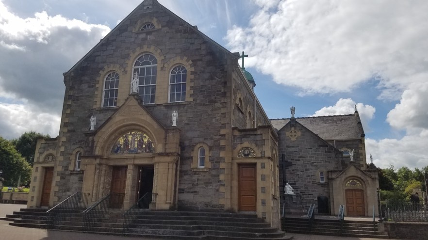
St. Columba’s Church Long Tower
The Guildhall is a building in which the elected members of Derry and Strabane District Council meet. The original 17th-century Guildhall was located in the Diamond area of the Walled City. Its name reflected the status of Londonderry as being founded by the City & Guilds of London. This building was destroyed by fire in Victorian times and it was decided to turn the site of the former Guildhall into a city square. Work started on the new Guildhall in 1887 and it was opened in July 1890. The new building was originally titled “Victoria Hall” and the name “Victoria Hall” was discovered on foundation stones found during recent restoration work financed by the Derry City Council. The reason for retaining the Guildhall name is presently unclear. It was badly damaged by fire on Easter, 1908, with only the clock tower surviving the fire. The whole building was re-built and renovated after the fire and re-opened in 1912. During The Troubles the Guildhall was the focus of multiple terror attacks. The building was badly damaged by two bombs in 1972, but was restored and reopened in 1977.
The square in front of the Guildhall is the main city square. It regularly plays host to important events and was the staging area for the visit of US President Bill Clinton when he visited the city in November 1995. It is also the home for many city events, such as Halloween carnivals, Christmas lights, and the Christmas European Market. The Square has been renovated and restructured and includes seating areas, fountains, improved cross-city transport links, and elegant night-time lighting. To the North, it adjoins Waterloo Place and together they link Derry’s main shopping, cultural, and tourist areas.
The most popular attraction in the building is the pipe organ and stained glass windows in the main hall. Located on the second floor, this hall contains a large, carved-oak organ that plays while different color lights shine on the pipes, and numerous stained glass windows on the long wall and the wall opposite the organ.
For more pictures, check out my album on Facebook.
Peace Bridge over the River Foyle was opened in 2011 and bridges a 400 year old physical and political gap between two sides of a once divided community. With two structural arms heading in opposite directions, symbolizing the unification of both communities from the opposite sides of the river, the Protestant Waterside and the Nationalist Bogside, these two opposed and independent arms are now united in a symbolic handshake across the river. This 770 ft (235 m) long, 13 ft (4 m) wide curved bridge with a footpath, track, and cycleway, stretches from the Guildhall in the city center to Ebrington Square and St Columb’s Park on the far side of the river.
For more pictures, check out my album on Facebook.

Peace Bridge
St. Eugene’s Cathedral: In November 1849, the site for St. Eugene’s Cathedral was purchased and the foundation stone was laid on July 26, 1851. For nearly quarter of a century afterwards, stone was laid upon stone. The construction of the Cathedral was sporadic as the funds became available over twenty-five years, and owing to the difficulty in raising money, it was agreed to postpone the building of the tower, belfry, and spire until a later date. Due to the lack of funds in the diocese, the windows were initially all plain glass and it was only in the later years that the stained glass was installed.
The Cathedral was solemnly opened on the May 4, 1873 by Bishop Kelly, in the presence of Cardinal McGettigan and all the Catholic Bishops of the North. The sacred vessels (chalice, paten, ciborium, cruets, and tray) used that day are still in the Cathedral. The chalice continues to be used by the Bishop on special church occasions, the Holy Saturday night vigil, and Christmas Midnight Mass.
The movement for the building of the spire was started at a meeting in St. Columb’s Hall on April 4, 1899. Work began on August 13, 1900, and the last stone was placed on the 256 ft (78 m) spire on June 19, 1903. On June 27, 1903, an 8 ft (2.5 m) high granite cross, weighing 15 cwts (1,680 lbs / 762 kg), and secured by a rod of gun metal, was sunk 30 ft (9 m) into the spire.
When the debt for the Cathedral had been cleared, it was solemnly consecrated on April 21, 1936. To commemorate the Solemn Consecration, all the clergy present on the day signed a visitors’ book. Since that time, the book, which is kept in the sacristy, has been signed by special visitors to the Cathedral.
Like St. Columb’s Church Long Tower, the cathedral was empty when I arrived. I pushed open the massive swinging door which creaked very loudly and echoed through the empty cathedral. I was able to walk around and admire every part of the cathedral with no other visitors. The inside is open, bright, and not as ornate as an older cathedral would be. If you can visit Derry on a Sunday afternoon, it would be the perfect time to check out the sites with very few tourists around.
For more pictures, check out my album on Facebook.
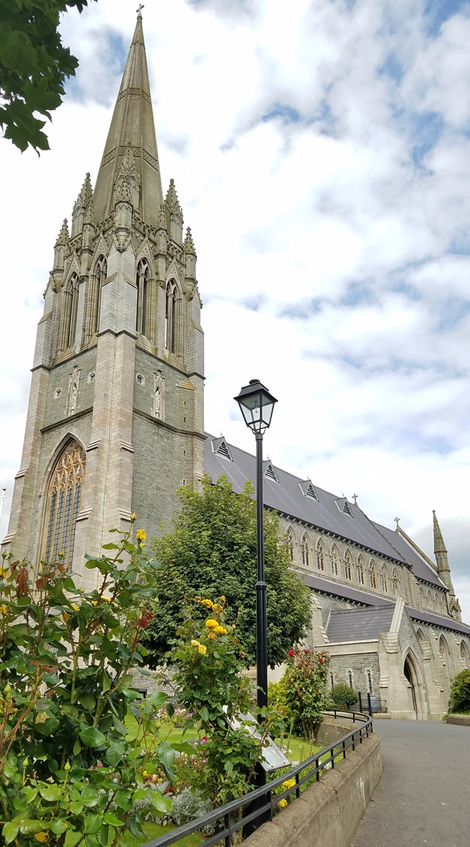
St. Eugene’s Cathedral
The Dark Hedges (Bregagh Rd.) is a beautiful avenue of beech trees located about an hour East of Londonderry. The trees were planted by the Stuart family in the eighteenth century and was intended as an interesting landscape feature to impress visitors as they approached the entrance to their Georgian mansion, Gracehill House., which is located at the Northern end of the road. Two centuries later, the trees remain a magnificent sight and have become one of the most photographed natural phenomena in Northern Ireland. The iconic trees have been used as a filming location in HBO’s epic series Game of Thrones, representing the King’s Road.
While most directions will take you to the Northern end of the road, Ballinlea Rd., this is the most busy end of the road. Cars and people line both sides of the narrow road and take away from the view. I found it better to take Ballykenver Rd. to the Southern end of Bregagh Rd. There are fewer cars and people here, plus there is a curve in the road that can hide vehicle when trying to take a good picture.
Since this is the most photographed natural phenomena in Northern Ireland, it is always very busy. The best time to arrive is at dawn or dusk, before the crowds arrive or after most have left. I went just before sunset and there were still a large number of people at the Northern end, but the Southern end, where my pictures are from, were pretty open. I would have stayed later, but I wanted to get to Giant’s Causeway before dark.
For more pictures, check out my album on Facebook.
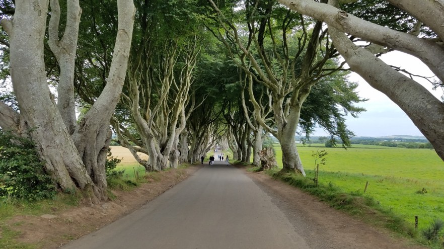
The Dark Hedges
Giant’s Causeway is about 20 minutes North of The Dark Hedges in County Antrim on the Northern coast of Northern Ireland, about 3 mi (4.8 km) Northeast of Bushmills. The Giant’s Causeway is an area of about 40,000 interlocking basalt columns, the result of an ancient volcanic eruption. It is located It was declared a World Heritage Site by UNESCO in 1986 (Northern Ireland’s only World Heritage Site), and a national nature reserve in 1987 by the Department of the Environment for Northern Ireland. The tops of the columns form stepping-stones that lead from the cliff foot and disappear under the sea. Most of the columns are hexagonal, although there are also some with four, five, seven or eight sides. The tallest are about 39 ft (12 m) high, and the solidified lava in the cliffs is 92 ft (28 m) thick in places.
The top 6 sites at the Causeway are:
1. Grand Causeway: The Grand Causeway is the largest of three rock outcrops which make up the Giant’s Causeway. These collections of curious columns contributed to the causeway being designated Northern Ireland’s only World Heritage Site by UNESCO in 1986.
2. Visitor Center: Officially opened in July 2012, the Giant’s Causeway Visitor Center was the result of an international architecture competition. The building has won many prestigious awards for design innovation and sustainability.
3. Giant’s Boot: In Port Noffer you’ll find a small path leading towards the sea. This takes you to what is perhaps the bay’s most famous feature – the Giant’s Boot. Apparently lost by Finn as he fled from the wrath of Scottish giant, Benandonner, the boot is reputed to be a size 93.5!
4. Wishing Chair: An essential stop on any visit to the causeway, the Wishing Chair is a natural throne formed from a perfectly arranged set of columns. It has been sat on so often, the basalt stones are shiny, smooth and very comfortable! Some years ago only ladies were permitted to sit in the Wishing Chair.
5. The Camel: Portnaboe’s most famous resident is Finn McCool’s camel. Once a living and lively beast, the camel was turned to stone and lies along the bottom of the cliffs. Apparently he was the only steed capable of carrying Finn home across long distances. The Camel is actually a basaltic dyke, formed from cooling lava which has pushed its way through other layers of rock.
6. Shepherd’s Steps: Made up of 167 steep steps, the Shepherd’s Steps are not for the faint of heart. They are best experienced descending from the Red Trail along the clifftop.
Entry to the site is £10.50 ($13.65), but I went after they closed, so it was free. From the parking lot, it is a 0.75 mi (1.2 km) walk to the main part of the Causeway. From there, you can continue another 1.25 – 1.5 mi (2 – 2.4 km) out to Lacada Point, if you would like. I wish I had more time to spend there before it got dark. I would have liked to hike more around the area.
For more pictures, check out my album on Facebook.
After leaving the Giant’s Causeway, I had a 50 mi (80.5 km) drive to the Keef Halla Country House where I was spending the night, about 20 minutes NE of Belfast, near the Belfast International Airport (2.5 mi / 4 km). Keef Halla Country House is a 4-star guest house and provides excellent accommodations. All seven bedrooms have private en-suite bathrooms, 32″ digital TVs, direct dial telephone, tea/coffee-making facilities, mineral water, and mints. Free broadband / WiFi, Internet, email and fax services are available. The property offers a limited amount of free car parking.
I used Booking.com for the reservation and had requested parking. When I arrived, I was told to park my car right outside the door, against the building. This spot was great for getting my luggage to the room and back to the car in the morning. My room was great and had 2 beds (a double and a single), a small couch, desk, and large bathroom. It was a very comfortable stay and was reasonably priced being so close to the airport and Belfast.
Belfast
Belfast is the capital and largest city of Northern Ireland, and the second largest on the island of Ireland. By the early 1800s the former town was home to a major port. Belfast played a key role in the Industrial Revolution in the 19th century, becoming the biggest linen producer in the world, earning it the nickname “Linenopolis”. By the time it was granted city status in 1888, it was a major center of the Irish linen as well as tobacco-processing, rope-making, and shipbuilding industries. Harland and Wolff, which built the RMS Titanic, was the world’s biggest and most productive shipyard. It later also sustained a major aerospace and missiles industry. Industrialization, and the inward migration it brought, made Belfast Ireland’s biggest city at the time. It became the capital of Northern Ireland following the Partition of Ireland in 1922. Its status as a global industrial center ended in the decades after WWII.
The city suffered greatly during “The Troubles”, and in the 1970s and 1980s was considered one of the world’s most dangerous cities. Since the 21st century, the city has undergone a sustained period of calm, free from the intense political violence of former years, and substantial economic and commercial growth. Today, Belfast remains a center for industry, as well as the arts, higher education, business, and law, and is the economic center of Northern Ireland. Belfast is still a major port, with commercial and industrial docks dominating the Belfast Lough shoreline, including the Harland and Wolff shipyard.
I found Belfast to be a very small city. I parked at the St. Anne’s Square Car Park, located adjacent to the St. Anne’s Cathedral (Belfast Cathedral) and could walk to any of the city’s attractions within 25 minutes. While I was here for the day, I also decided to do my laundry at Spin City Belfast, which is the only self-service laundromat in Belfast City Center. Once I got my laundry started, I grabbed a sandwich while waiting. I swapped my laundry over to the dryer and headed off to check out the city.
First stop was the Albert Memorial Clock. The clock was built as a memorial to Queen Victoria’s late Prince Consort, Prince Albert. The sandstone memorial was constructed between 1865 and 1869 and stands 113 ft (34 m) tall in a mix of French and Italian Gothic styles. The base of the tower features flying buttresses with heraldic lions. A statue of the Prince in the robes of a Knight of the Garter stands on the western side, a 2 tonne (4,409 lb) bell is housed in the tower, and the clock was made by Francis Moore of High Street, Belfast.
As a result of being built on wooden piles on marshy, reclaimed land around the River Farset, the top of the tower leans 4 ft (1.2 m) off the perpendicular. Due to this movement, some ornamental work on the belfry was removed in 1924 along with a stone canopy over the statue of the Prince.
Being situated close to the docks, the tower was once infamous for being frequented by prostitutes looking to entertain visiting sailors. However, in recent years regeneration has turned the surrounding Queen’s Square and Custom’s House Square into attractive, modern public spaces with trees, fountains, and sculptures.
For more pictures, check out my album on Facebook.
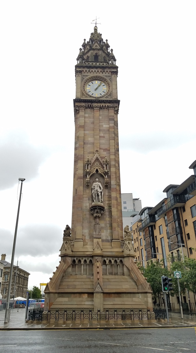
Albert Memorial Clock
McHughs Bar is of historic and architectural significance as the earliest known building in Belfast. The original gable exhibits several early construction techniques that are rare in the context of Northern Ireland, including brick noggin walling and early handmade brick; timbers are also of an early date and offer valuable evidence of early construction techniques. Evidence of historic changes in the Victorian era is also visible. The Victorian rendering of the front of the property contributed to the concealment of the bars true age until 1997.
An archaeological survey of McHughs Bar in 1997 found the site to be “by far the oldest building to have survived in Belfast”. Built between 1710 and 1715 (the sign says 1711), no. 29-31/33 Queens Square were constructed at the time as part of the Hanover Quay development between 1710 and 1720 and given that “not even one standing wall of pre-1769 was previously known to have survived anywhere in Belfast, it is particularly fortunate to find that this building is not only essentially intact, but also represents such an important part of the early town”.
For more pictures, check out my album on Facebook.
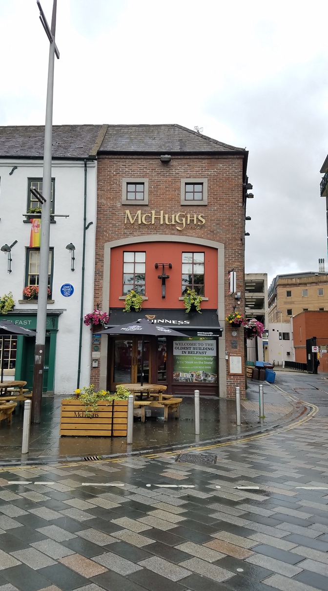
McHughs
The Big Fish (The Salmon of Knowledge) was commissioned in 1999 to celebrate the regeneration of the River Lagan and the historic importance of the site. The outer skin of the fish is a cladding of ceramic tiles decorated with texts and images relating to the history of Belfast. According to the Belfast City Council, each scale “tells a story about the city”. Material from Tudor times to present day newspaper headlines are included along with contributions from Belfast school children. The Ulster Museum provided the primary source of historic images, while local schools/day care centers located along the River Farset were approached to provide drawings for the fish. The Big Fish contains a time capsule storing information, images, and poetry on the City.
For more pictures, check out my album on Facebook.
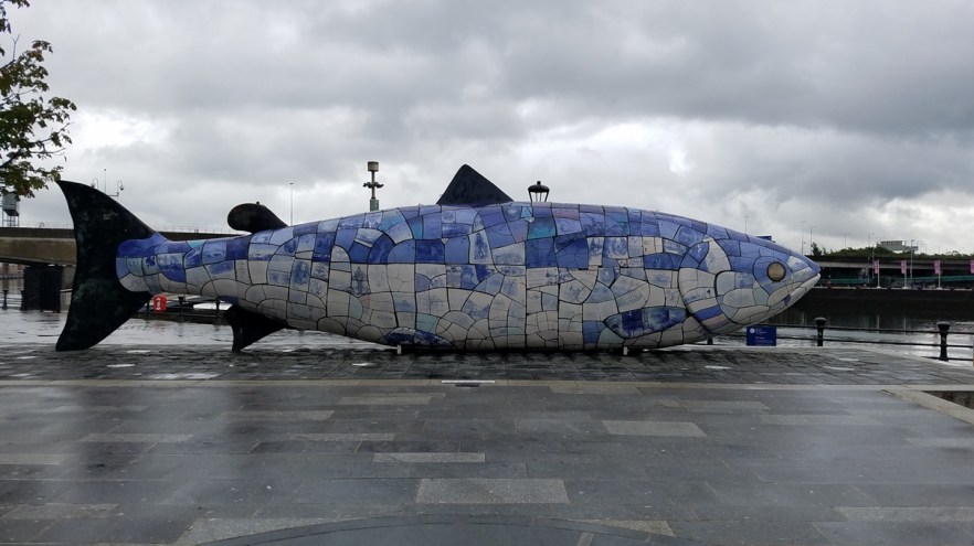
The Big Fish / The Salmon of Knowledge
Lagan Wier was completed in 1994 and is located across the Lagan River between the Queen Elizabeth Bridge and the M3 bridge. The weir is a series of massive steel barriers which are raised as the tide retreats to keep the river at an artificially constant level. This improvement to the sewerage system combined with massive dredging of the river by mechanical excavators, and installation of an underwater aeration system, has led to a great improvement in water quality and the environment around the river. Lagan Weir, dredging, and aeration have increased water quality in the river enough that salmon are returning. An otter and seals have followed the fish that now move up river to spawn in what was once uninhabitable.
The objective of the structure is to keep the level of the river artificially constant, as it is a tidal river the level of the water varied by up to 10 ft (3 m) between high and low tide. This exposed mudflats which were unsightly and emitted a strong odor, particularly in the summer months.The transformation of the riverside by the construction of the weir has been a catalyst for development along the riverside.
For more pictures, check out my album on Facebook.

Lagan Wier
St. Anne’s Cathedral (Belfast Cathedral) is unusual in serving two separate dioceses and is the focal point of the Cathedral Quarter in Belfast. Built over a period of 80 years, the foundation stone to Belfast Cathedral was laid in 1899 and the nave was consecrated in 1904. The new cathedral was built around the old parish church, which remained in use up until December 27, 1903, when the last service was held in it. The parish church, with the exception of the sanctuary, which was incorporated in to the new cathedral, was then demolished. In 1981 the North Transept was finished and in 2007 the addition of the Spire of Hope was made to the cathedral.
Entry to the cathedral was £5.00 ($6.50) for a self-guided tour and £6.00 ($7.80) for a guided tour.
For more pictures, check out my album on Facebook.
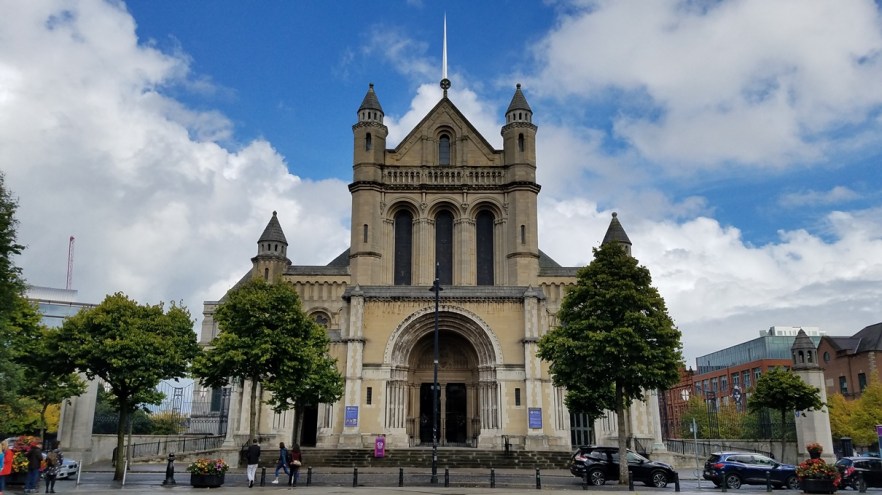
St. Anne’s Cathedral / Belfast Cathedral
Titanic Belfast is located across the river and since I was at St. Anne’s Cathedral where I parked, I got the car and drove. There is a parking garage under the Titanic Belfast, so I parked there. Titanic Belfast is a visitor attraction and a monument to Belfast’s maritime heritage on the site of the former Harland & Wolff shipyard in the city’s Titanic Quarter where the RMS Titanic was built. It tells the stories of the ill-fated Titanic, which hit an iceberg and sank during her maiden voyage in 1912, and her sister ships RMS Olympic and HMHS Britannic. The building contains more than 130,000 sq ft (12,000 sq m) of floor space, most of which is occupied by a series of galleries, plus private function rooms and community facilities.
Entry to the exhibit (including entrance to SS Nomadic) was £18.00 ($23.40) and had an entry time on the ticket. If your wait is long enough (30 minutes or more) you can take a quick walk through the SS Nomadic across the street first. If not, you can check it out after the museum.
Personally, I did not find Titanic Belfast to be worth the entry fee. The SS Nomadic is a distraction from the wait in the main attraction, which is to help keep groups spread out so areas don’t become too crowded. It had many interactive exhibits, some replicas of the different classes of rooms, a 270 degree virtual tour through the ship, and a number of panels with facts and stories. *SPOILER ALERT* One of the most sobering exhibits is near the end when you hear the transmissions between ships in the area and the Titanic as it was breaking up and sinking.
For more pictures, check out my album on Facebook.
Now back to Ireland! (See Ireland – August 2017)
I hope this gives you some inspiration to take a trip to Ireland. For photos from the entire trip, check out all my albums on Facebook and my YouTube channel.
Please share with your friends using the links below. If you have any questions or comments, please reply using the box below.
Thanks for reading!
