Length: 23 days
Tour Company: N/A
Tour: Edda’s Great Norway Road Trip
Traveler: Dave and Edda
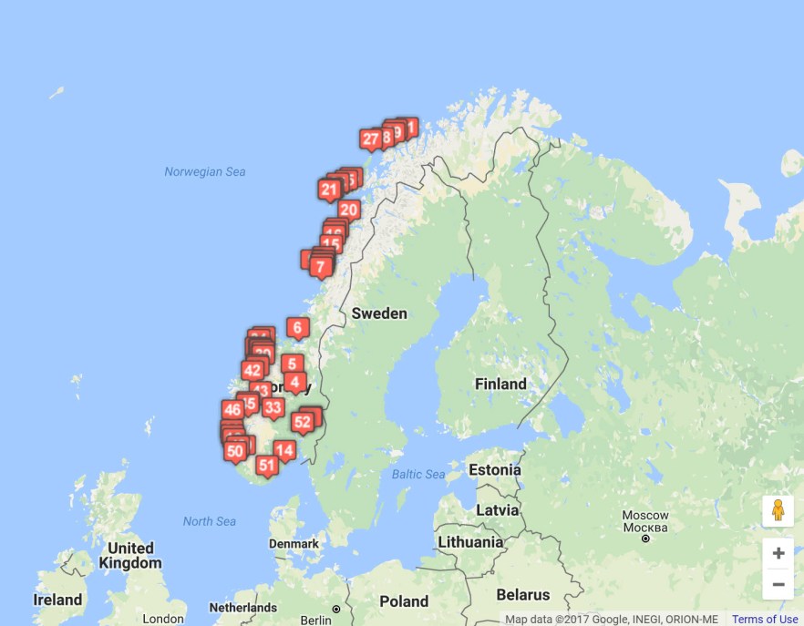
As you can see on the map above, this was quite the road trip over the 3 weeks in Norway. The numbers above represent the towns/cities we drove through on the trip (not in order) from Oslo to Tromsø via the central and Western parts of the country, followed by a ferry trip from Tromsø to Kristiansund, and finally driving the South-Western and Southern parts of Norway. This trip was done in the summer and road closures in Norway are common in the winter as well as after storms in the summer. Be sure to have alternate plans in case of road closures. Places visited:
1 – Oslo
2 – Vormsund
3 – Fåvang
4 – Rondane Nasjonalpark
5 – Trondheim
6 – Brønnøysund
7 – Vega
8 – Levang
9 – Bodø
10 – Moskones
11 – Å
12 – Reine
13 – Heningsvær
14 – Svolvær
15 – Andenes
16 – Tromsø
17 – Kristiansund
18 – Molde
19 – Åndalsnes
20 – Trollsteigen
21 – Geiranger
22 – Dalsnibba
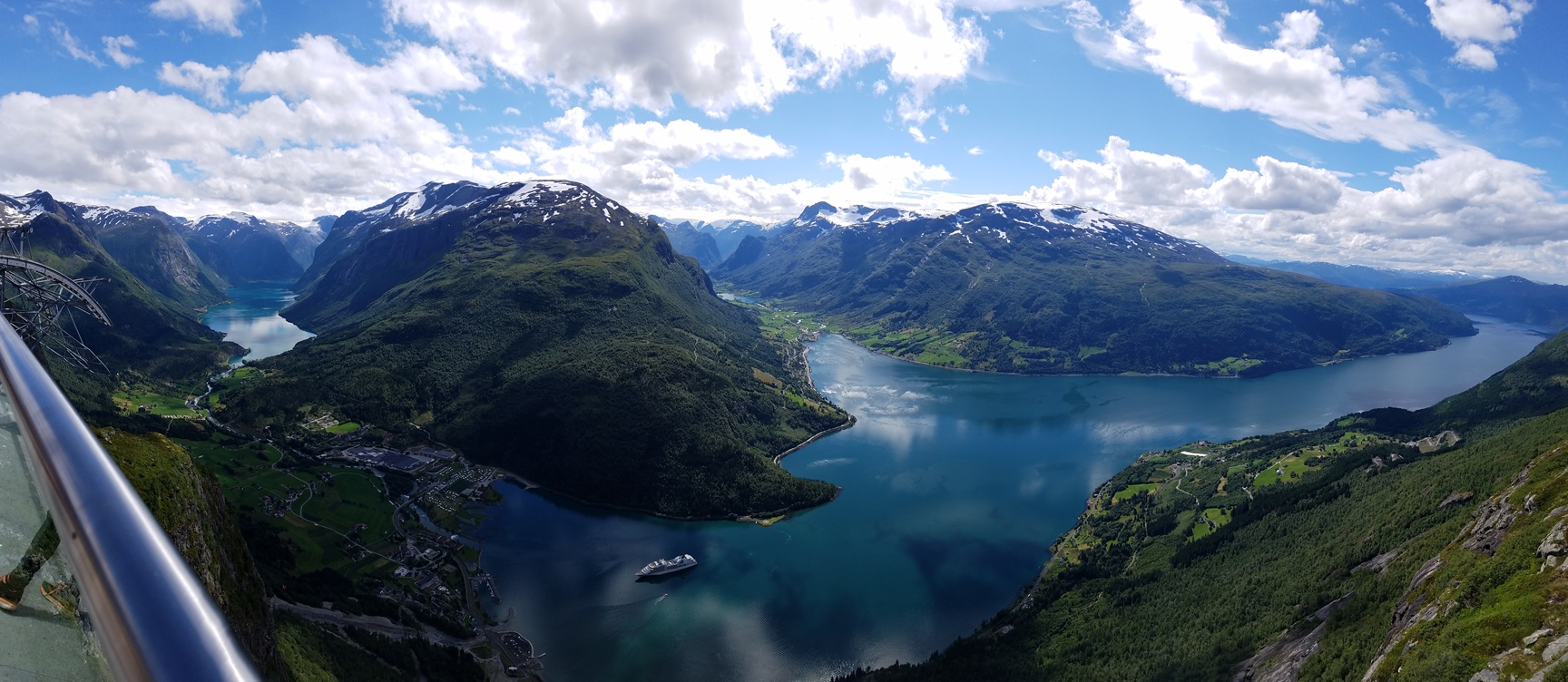
23 – Loen
24 – Voss
25 – Bergen
26 – Haugesund
27 – Stavagner
28 – Preikestolen (Pulpit Rock)
29 – Kristiansand
30 – Oslo
I took the NSB train from Göteborg, Sweden, to Vestby, Norway, but I wanted to go to Oslo Central Station. The tracks between Vestby and Oslo are under construction so the train stops in Vestby and passengers transfer to buses for the rest of the journey to Oslo. Rather than take a bus to Oslo, my friend Edda picked me up in Vestby. The journey took about 4.5 hours and the train was quite comfortable and has a dining car with vending machines, restrooms, and WiFi. Crossing the border between Sweden and Norway was nothing more than an announcement that we were crossing.
The first night was spent in Oslo and checking out the plans for the road trip ahead. I was definitely not prepared to see a binder with 100+ pages of information of every hour for the next 3.5 weeks. There were driving directions, hotel and camp site information, ferry schedules, excursion information, etc. This was way more involved than I was expecting and I am super appreciative of all the work that went in to planning the trip. Thanks, Edda!!
During the trip, I picked up a SIM card from Telia Norway. The card and 3GB of data, for 30 days, cost 328 NOK ($41.42). The coverage was pretty good throughout Norway, but due to the remoteness of the country, signal was not always great. I managed to burn through 3GB of data in 4 days, apparently, though. Turns out Instagram was using tons of data in the background to load those stories at the top of the screen. Be sure to enable the Limit Mobile Data Usage so that apps are not eating up your data without you realizing it. I ended up having to buy another 3GB of data for 299 NOK ($37.75) for the rest of the trip. This time I used the Limit Mobile Data Usage and stayed off Instagram unless I was on WiFi and that 3GB lasted me all the way through the next 3 weeks, plus a week in Ireland. Thankfully mobile data in Europe is ‘roam like you’re home’, so you can use your home data in another country without being charged extra (you hear that U.S. companies??!!) Setup was pretty easy as I used the WiFi at my friend’s apartment to look up the APN information:
Name: NO – Telia
APN: telia
Proxy:
Port:
Username:
Password:
Server:
MMSC:
MMS Proxy:
MMS Port:
MMS Protocol: IPv4
MCC: 242
MNC: 02
Authentication Type: None
APN Type: default, supl
APN Protocol: IPv4
APN Roaming Protocol: IPv4
Vormsund
First stop out of Oslo was to the small community of Vormsund where we saw the Nes Kirkeruiner (Nes Church Ruins). The church was built in the 1100s as a long church, converted to a cross church in 1697, and was eventually struck by lightning in 1854. It was never rebuilt and can currently be rented out for private functions, including weddings.
We next stopped at the Gamle Hvam Museum (Old Hvam Museum), which is a farm museum in the small community of Hvam, in the Nes Kommune. The museum has a number of buildings that house different types of farming equipment, animals, plants, general store, family home, etc. The museum gives a look into the history of a wealthy farming family in the area from the 1700s to current.
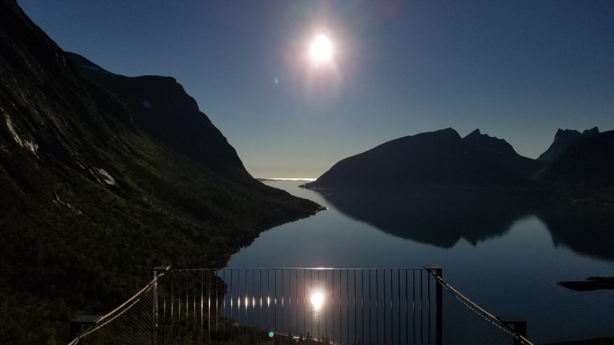
We spent the night in a quaint mountain cabin (no electricity or running water) near Fåvang. The views of the valley below the mountain were spectacular. This picture is the valley below, not from the actual cabin, which was over the top of the mountain from here.
For more pictures and videos, check out my album on Facebook or check out my YouTube channel.
The next morning, we headed to Trondheim through the Rondane Nasjonalpark (via 27 to Folldal).
Trondeheim
We arrived in Trondheim and checked into the Scandic Hotel Solsiden, which is located right next to the Solsiden Shopping Center (mall). The hotel was comfortable, has WiFi, and a substantial breakfast buffet was included in the room rate. There is a parking garage next to the hotel, but it is not free for guests.
The Gamle Bybru (Old Town Bridge) is a popular stop for visitors to Trondheim because of the view of the Old Town that you get from the bridge, similar to the view of Nyhavn in Copenhagen.
For more pictures and videos, check out my album on Facebook or check out my YouTube channel.

Nidaros Domkirke (Nidaros Cathedral) is one of the most beautiful cathedrals I’ve ever seen. Unfortunately, they do not allow photographs to be taken inside the cathedral. Considering they charge to enter the church, you should be able to take pictures. It was built from 1070 to 1300 and is the northernmost medieval cathedral in the world. Here are a few pictures of the outside, but to see the inside, you will have to check their website (linked above) or search Google for the interior.
For more pictures and videos, check out my album on Facebook or check out my YouTube channel.
We stopped at the NTNU University Museum to check out the Body Worlds Vital exhibit. This exhibit is similar to those that have been traveling around the world for the past few years and brings together a collection of real human bodies, specimens, organs and body slices which have been willed by donors and preserved through plastination, a ground-breaking method for specimen preservation invented by Dr. Gunther von Hagens. This was the first time I had actually seen the exhibit and am quite impressed with what they have been able to display.
For more pictures and videos, check out my album on Facebook or check out my YouTube channel.
From Trondheim, we headed north to Torghatten and Torghatten Camping for our first night camping in Norway. The campsite sits in the shadow of Torghatten Mountain, which we visited the next morning.
Torghatten Mountain is internationally renowned and is pierced all the way through by a 160 m (525 ft) long, 15-20 m (50-65 ft) wide, and 35 m (115 ft) tall tunnel that has been formed by powerful natural forces. Legend has it that the troll Lekamøya and her seven sisters were fleeing from Vågekallen, who was desperate to capture a wife. The king heard them and came to the rescue of the young maidens. But then Hestmannen, who had been awakened by the noise, got up and shot an arrow towards the maidens. The king threw his hat toward the maidens to protect them. At the moment the arrow pierced the hat, the sun appeared and its rays turned the trolls, as well as the Brønnøy King’s pierced hat, into stone.
The hike from the parking lot takes around 20-30 minutes and the second half is up large rocks. Once inside the cave, the rocks and ground can be quite slippery, so be cautious when walking. Be sure to wear appropriate shoes for hiking on rocks and in mud.
For more pictures and videos, check out my album on Facebook or check out my YouTube channel.
After hiking to Torghatten, the rest of the day was filled with driving North to Horn, then took a ferry to the UNESCO World Heritage Site of Vega. After arriving at Vega, we hoped to make the ferry to Tjøtta (last ferry of the night), but we were literally the last vehicle in line and the ONLY vehicle that did not get on the ferry. Our only option to keep moving that night was to take the next ferry back to Horn and see how far we could go before the ferries stopped for the night. So, we arrived back in Horn and took another ferry from Horn to Andalsvågen, drove to Forvik, took a ferry to Tjøtta, and drove to Levang, but arrived much too late to catch the ferry to Nesna, so we set up the tent on the side of the road about 5 minutes away from the ferry and woke up at 4am to be sure to catch the first ferry of the day. Waking up at 4 am allowed for some great pictures of the calm harbor while waiting for the ferry.
For more pictures and videos, check out my album on Facebook or check out my YouTube channel.
The rest of the day would be filled with more driving and ferries. Once in Nesna we drove to Kilboghavn on FV-17 and then took the ferry to Jektvik (crossing the Arctic Circle), drove to Ågskardet, took the ferry to Forøy, drove past Svartisen Glacier to Saltstraumen to see the world’s strongest tidal currents in the world, and then drove to our stop for the night, Bodø. We checked in to the Scandic Hotel Bodø. As with the last Scandic hotel, the room was quite comfortable, WiFi was available throughout the hotel, and they had a large breakfast buffet. Parking was available on the street, for free, until 8:00am, which worked for us as we had a reservation on the 9:00 ferry to Lofoten.
Saltstraumen
Saltstraumen is the world’s strongest maelstrom (tidal current) and it is extremely impressive. The water rushing in and out of the Skjerstadfjord to the Saltfjord under Staltstraum bridge, depending on the tide rising or falling, through such a narrow passage (150 m / 492 ft wide and 3 km (1.86 mi) long) creates a flow of up to 20 kph (12.4 mph), but it’s the whirlpools (up to 10 m (33 ft) in diameter and 4-5 m (13-16.5 ft) deep) and surges of water that are the issue. See below for some pictures and a video of the Maelstrom at Saltstraumen.
Also while here, we tried to have lunch at Magic Saltstraumen and have some ‘Traditional Norwegian Food’. The service was awful as the girl behind the counter had no clue what was on the menu, didn’t speak Norwegian, didn’t know the price of anything, kept playing with her phone, and would ignore customers standing in front of her waiting. The food was no better. My friend is Norwegian and she said the food was not even close to right in preparation or taste. It was the worst of that dish she’d ever had. My food was not much better and you could tell it was just microwaved, especially the ‘fresh vegetables’. If you’re in the area, don’t eat here. There are other places nearby to try.
For more pictures and videos of all that was along the drive to Bodø, check out my Part 1 album and Part 2 album on Facebook or check out my YouTube channel.
Early the next morning, we filled up the fuel, had some breakfast, and boarded a 3.5 hour long ferry to Moskenes, where I caught my first glimpse of the Lofoten islands. Once we arrived in Moskenes, we drove to Å to take a look at some of the beautiful scenery that was to come in Lofoten. We continued on to Reine, Ballstad, and down to Henningsvær where we had a great dinner at Lofotmat Restaurant. Costs are high, but that’s Norway, but it really is a nice place with rooftop seating if it’s nice out or indoor seating if it’s not. I recommend stopping in for a visit if you’re in the area.
After dinner, we continued on to Svolvær, where we spent the night at Kabelvåg Camping, about 7.5 km (4.7 mi) outside the town. They were quite full, but we were able to find a spot for our tent and car. The campground is affordable (Norway standards) and has everything needed for the night including a kitchen, showers, and toilets.
The next morning we went on a rib-boat tour with Lofoten Explorer to Trollsfjord and to see the Sea Eagles. A rib-boat is basically a fast boat with rubber sides and a metal hull. These boats allow you to get where you’re going, quickly, and get up close to things because they are small and have a shallow draft. Here are a few pictures and a video of the tour:
After the rib-boat tour, we had lunch at Bacalao Bar right next to the tour office and has an outdoor seating area overlooking the Svolvær harbor. We actually ate here twice, once after the rib-boat tour, and once later in the trip when our cruise ferry docked in Svolvær for a few hours. To order, you find a table (outside), which has a number on it, then go into the bar and order for your table number and pay. They will bring your food to your table. Inside did not have table numbers, but you just point them to where you’re sitting and the person who brings out the food is able to find you. The first time, the food was better than the second, but their selection of cakes and other pastries at lunch looked amazing. In all, I would recommend visiting Bacalao Bar if you’re in Svolvær, but there are a few other places along the same area of the harbor.
Next, we decided to check out Magic Ice, the world’s first and largest permanent ice gallery and ice bar. Admission is 175 NOK ($22.13) per person and includes a welcome drink in an ice glass, a parka, and gloves as it is -6º C (21º F), dry, and windy from the coolers keeping the room so cold at all times. The gallery is filled with ice sculptures that cover a wide range of topics, such as fishing, vikings, shapes, plants, sea creatures, boats, etc. Check out the pics below. For more pictures and videos, check out my Part 3 album on Facebook or check out my YouTube channel.
Andenes
From Svolvær, we drove a few more hours north to Andenes on the northern tip of Andøya island. Lodging for the night was at Andenes Camping, who happens to be part of the Whale Safari company we went with the next morning. Andenes Camping is located on a beautiful stretch of beach along the Norwegian Sea. The campground was really busy, because of its location and affiliation with the Whale Safari, but we found a little corner to put up our tent for the night. Here are a few pictures of the drive. For more, check out my album on Facebook or check out my YouTube channel.
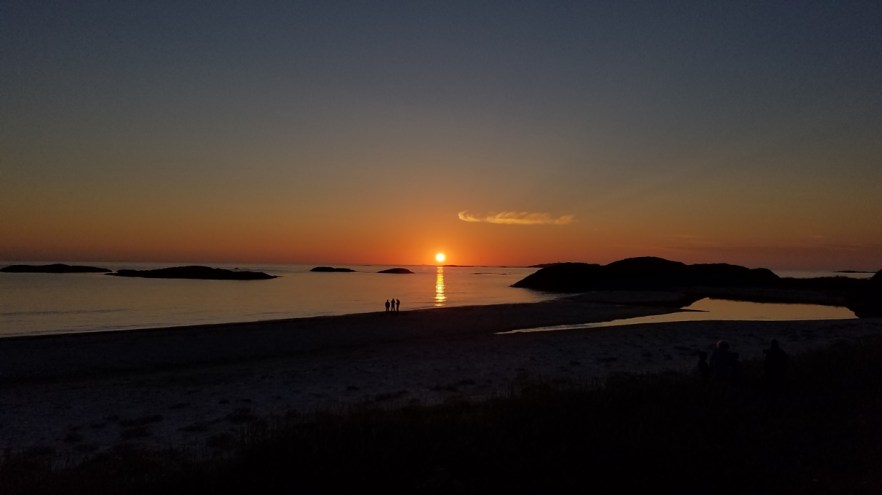
That night ended up being the last night that the midnight sun would be visible and the campground had a front row seat. The next day, the sun would actually dip below the horizon, but not the night we were there. Check out my photo below (that’s the lowest the sun got all night) and my album on Facebook for more or check out my YouTube channel.
Early the next morning, we packed up the camping gear and reported to the Hvalsafari (Whale Safari) AS office for our tour. The tour costs 975 NOK ($125) per person and includes, a Whale Guarantee (if you don’t see a whale, they will put you on another trip as soon as possible, or refund your money, minus an admin fee and the museum ticket cost), a guided museum tour, a guided boat trip to the whale grounds (found through aqua-microphones on the boat), coffee, tea, and biscuits on the way out to the grounds, vegetable soup with bread on the way back (if you’re on the M/S Reine, which we were), and a participant diploma with check-boxes for what we saw on the trip. Check in for the tour is 2.5 hours ahead of the time you book. This is to get everyone checked in and run the museum tour before getting on the boat. So, we reported to the whale center at 9:00 am for our tour at 11:30. The boat tour couldn’t have been on a better day. The water was calm, the sky clear, and breeze was cool, but not bad. After a few hours of seeing jelly-fish, sea-gulls, and puffins, we finally spotted a sperm whale and watched it on the surface for about 15 minutes before it dove deep. We waited 20-25 minutes before seeing another one (possibly the same one) and waited for it to dive before heading back in. The boat didn’t get back until 4:45 pm, just barely in time to get on the Ferry from Andenes to Gryllefjord. We literally had to run off the boat, to the car, speed over to the ferry and drive right on as the rest of the cars had loaded. Thankfully they “wait for the whale boat customers”, or so they say. The door closed and ship left pretty quickly after we drove on. For pictures of the whale safari, look below and for more check out my album on Facebook or check out my YouTube channel.
The next part of the trip took us from Gryllefjord to Botnhamn, another ferry to Brensholmen and a few hour drive to Tromsø for the next 24 hours. Here’s a photo I took along the way to Tromsø. For more, check out my Part 4 album on Facebook or check out my YouTube channel.
Tromsø
We arrived rather late into Tromsø, so the hotel we booked, the Skansen Hotel Tromsø, arranged to leave the key to our room in the safe outside near the Night Entrance. Well, we arrived, entered the code to the safe, opened it and NO KEYS! 1:30 am, all our bags in hand, not a soul in sight, the hotel is locked, and no keys. We called the 24-hour number on the door and spoke to a security guard who came right over and opened the door, went to reception, found our key, and showed us to the room. The guards helpfulness was the highlight of this place, for sure. The room, despite being a non-smoking room, smelled of smoke. Judging by the burn marks of what looks like a mini-fridge on the wall, I’m guessing that a burned fridge didn’t help the smell of the room. The walls were covered in mirrors, the smoke detector was outside the window on the grass roof, along with hundreds of cigarettes and another smoke detector. There were also no towels in the room, bath, face,hand, or otherwise. I definitely DO NOT recommend ever staying at this hotel if you’re in Tromsø. Norway is too nice and too expensive for that kind of service from a “hotel”.
After a short, overpriced sleep, we checked out of the hotel, put our bags in the car, and walked around Tromsø for a bit. We stopped for breakfast at a little coffee shop called Tromso Kaffebrenneri – Veita which had some great sandwiches and smoothies. I don’t drink coffee, so can’t comment on how the coffee tasted. They also had free WiFi.
After walking around Tromsø for a while, we got back in the car and crossed the bridge to see the Ishavskatedralen Tromsøysund Menighetshus, or the Arctic Cathedral. Built in 1965, the cathedral is simple, yet powerful. The sharp angles, the white interior, the bold stained glass, the shape of the organ, all blend together beautifully.
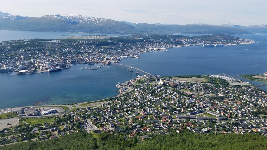
For a better view of Tromsø, it was time to go up the Fjellheisen Cable Car. A nice 170 NOK ($21.50) per person gets you on the cable car for a quick 4 minute ride to the top. Another option is to hike up the 421 m (1,380 ft) high mountain, which is only 752 m (2,467 ft) horizontally away from the start. That’s a 0.56 m (1.8 ft) elevation change for each 1 m (3.28 ft) you walk forward. Luckily the path snakes up the face of the mountain, which may cut the elevation change in half. It looks like and ,according to calculations, is a tough hike. Your reward for paying the fee or hiking to the top is a breathtaking view of the city and surrounding area. They are open year round and viewing the northern lights from here must be AMAZING!
There is also a restaurant at the top with views of the city. We had dinner here and the food was great, but a little more expensive than usual in Norway, because of the view and location.
Here is a picture from the top. To see more pictures, check out my album on Facebook or check out my YouTube channel.
With a few hours to kill before boarding the ferry cruise to southern Norway, we had time to visit the Arctic-Alpine Botanic Garden at the University of Tromsø. You could spend days here wandering around with all the different plants and flowers they have on display. It is free and open 24 hrs a day. Definitely take some time to wander around if you find yourself in Tromsø. Here are a few pictures from the garden. For more pictures and videos, check out my album on Facebook or check out my YouTube channel.
Thanks for the memories Tromsø, but it was time to board the Hurtigruten ferry for the next 3 days (2 days 15 hours) of relaxing while looking at the coasts and fjords of Norway. It’s a cruise that you can bring your car on (for a fee, of course) and a nice change of pace from the constant driving that we did over the past week. The routes run from Bergen in the south to Kirkenes in the far north. You can book any port to port route in between these ports (or the whole route, which is 7 days). We went from Tromsø to Kristiansund where we continued our drive around the south coast of Norway.
Kristiansund to Bergen
From Kristiansund, we drove along the coast to Molde, with a quick stop to hike the Bremsneshola (The Bremsnes Cave) before driving the famed Atlanterhavsveien (Atlantic Road).
The Bremsneshola (The Bremsnes Cave) is Norway’s largest cave, extending 80 m (263 ft) into the mountain. Many finds from the Fosna culture, dating back almost 10,000 years, have been made in the cave.
Atlanterhavsveien (Atlantic Road) is said to be the world’s most beautiful drive, but the rest of the drive through Norway had some pretty beautiful scenery too! Here are some photos of the Bremsneshola and Atlanterhavsveien and a time-lapse video of our journey along the Atlantic Road. For more pictures and videos, check out my album on Facebook or check out my YouTube channel.
We arrived in Molde too late to catch the ferry from Solsnes, so we stayed at the Hotell Molde Fjordstuer for the night. The hotel was quite comfortable with all the expected amenities like en-suite bathroom with a hot shower, spacious room, comfortable bed, free WiFi, and a restaurant (breakfast included or not is optional with your room choice). This hotel is a great quiet place to stop if you’re ever in the Molde area.
After a full breakfast, we loaded up the car and were on the way again. Today we headed for Loen via 64, 63, 15, FV60, and FV23 through Nesjestranda, Åfarnes, Åndalsnes, Trollsteigen, Geiranger, Dalsnibba, and Stryn.
Trollsteigen is part of the Norwegian Scenic Route between Geiranger to Trollstigen. The actual road at Trollstigen is closed in the winter and normally opens in late May or early June.
Approaching Trollstigen from the bottom is amazing. As you reach the end of the valley, you see the road turn into an 11 hairpin-bend, steep climb to the top of the 858 m (2,815 ft) above sea level rock face. Some places it’s cut into the mountain, some parts are built on top of stone walls, and there is a bridge made of natural stone that takes you across Stigfossen waterfall. The road dates back to the summer of 1936 when it was first opened.
At top of Trollstigen there are viewpoints and steel walkways which allow you to get close to the mountains and waterfalls. The service building houses a café with panoramic windows, souvenir shop, and toilets. The Trollstigen Plateau and the two spectacular viewpoints that provide full overview of the countryside was designed so that it blends in with the surroundings. Like the road itself, some parts are carved into the rock, while other parts are built on stone walls.
Continuing along the Scenic Road 63 towards Geirangerfjord, we passed over the mountains and back down to sea level where we caught another ferry (this happens often) from Linge to Eidsdal. We could have taken the ferry from Valldal directly to Geiranger, but the drive into Geiranger is very scenic and has another winding, steep, 11 hairpin turn road called Ørnesvingen (Eagle Road), similar to Trollstigen, that brings you into the small port of Geiranger. We also planned to take a boat tour of the Geirangerfjord once we arrived, so we didn’t need to take the direct ferry.
Geiranger is a very small port village that is full of tourists looking to see the beautiful waterfalls in the fjord, which include the Seven Sisters, the Suitor, and the Bridal Veil, which are visible by boat.
After our boat tour, we had dinner at the Friaren Bistro, which is part of the Hotell Geiranger, and located right along the Fjord. There is really nothing great to say about this bistro. The service was poor, at best, the food was just as bad, and the prices were quite high (even for Norway). There are only a handful of places to eat in the area, but, based on my experience, I recommend trying one of the other local establishments and avoiding this one.
Heading out of Geiranger along 63, we continued our journey towards Loen. We stopped along the way for pictures of the incredible beauty. Not far from Geiranger is an old stone bridge called the Knuten (the Knot) because of its shape. You drive under an arch, and up a 270 degree ramp, over the top of the arch, and come down on the other side. It’s a fun little distraction along the route.
Our next stop was to the Dalsnibba Utsiktspunkt (Dalsnibba Viewpoint) to check out the Geiranger Skywalk at 1500 m (4,921 ft) above the fjord. There is a toll to get up the access road, so be prepared with a credit card (with chip and PIN) in case there is no one at the booth. Once at the top, which is much colder than down in Geiranger, you are greeted with amazing views back towards the fjord
To see pictures of the fjord, the falls, and Dalsnibba, check out my album on Facebook or check out my YouTube channel.
The rest of the evening was spent driving to Stryn to find a place to camp for the night. We found a campsite near Loen called Tjugen Camping, located on FV723, between the Innvikfjorden and the freshwater glacial lake of Lovatnet. This isn’t a large campsite, but it was in a really nice location and was equipped with restrooms, showers, washing machine and dryer, kitchen, and living room with TV in the service building. We set up our tent in the fading light and were able to fall asleep quickly after another long day of driving and fun.
We awoke to a beautiful summer day, got ready for the day, packed up our camping equipment and headed 18 km (11.2 miles) farther up FV723 which ends at the entrance to the Kjenndalsbreen (Kjenndal Glacier). FV723 is a very narrow, single lane road, that has areas to pull to the side to allow oncoming traffic to pass. There are many roads in Norway that are like this, so be aware and pull to the side when the pull off area is on your side of the road. There is a small donation box located at the entrance with a recommended donation that you place in an envelope and in the box before passing, so have some cash with you to help support the upkeep of the parking area and trails. We parked the car, grabbed some water and extra layers and headed up the trail to the glacier. The valley ends at the glacier which spills over the mountains down into the valley, and has a powerful waterfall and river flowing from it. I felt very calm being in this valley up close and personal (as close as possible without more gear to cross waterfalls) with the glacier and the river. Here are some pictures of the valley and the glacier. For more pictures and videos, check out my album on Facebook or check out my YouTube channel.
Next, we headed back down FV723 towards Loen to ascent the newly built (May 2017) Loen Skylift. A Cable Car will lift you from the fjord to 1011 m (3,317 ft) in 5 minutes. Here you can enjoy the views of the fjord landscape, have a meal on the cliff looking our over the fjord, or hike in the mountains. There is also a hike that can get you to the top including the Via Ferrata hike which includes hikes over cable bridge high above the fjord. We had talked about doing this, but it is quite expensive at approximately 1300 NOK ($180.00) and takes a few hours. The 5 minute ride to the top worked well! The views were AMAZING and pictures just don’t do it justice. For more pictures and videos, check out my album on Facebook or check out my YouTube channel.
After the Loen Skylift, we were going to take the FV60 to Utvik and then over the mountains, but we heard on the radio that the road had been closed due to the landslides caused by recent heavy rain, so we had to go back through Stryn and take the E39. This route added a few hours to our journey, but took us by Hornindalsvatn Lake, which is the deepest lake in Europe at 514 m (1,686 ft). We passed through Lote, Sandane, stopped at Eidsfossen, continued through Skei, stopped at the Bøyabreen (Bøya Glacier), and lastly to Sognadal before stopping at Kjørnes Camping for the night.
Along the route, we stopped at Eidsfossen, which is a small, but powerful waterfall next to a hydroelectric power station. It was impressive since the area had received significant rainfall during the week leading up to our arrival.
The next stop was at Bøyabreen (Bøya Glacier) for a quick look around before heading to the campsite for the night.
Kjørnes Camping is located about 3 km (1.8 mi) from Sogndal along 5 and right on the water of Sognefjord. The grounds were extremely well maintained and the service buildings contains 5 star sanitary facilities, showers (pay to use), kitchen, and laundry (pay to use). WiFi is available in the main service building, but it limited or not available beyond the building.
The next morning, we packed up our camping equipment and were on the road again. We continued to follow 5 to Lærdalsøyri where we had planned to travel along the E16 through the World’s Longest Road Tunnel, Lærdalstunnel, then take the FV243 Scenic Route back over the mountains to Lærdalsøyri, before going through the tunnel again on our way to Voss, and finally on to Bergen. Well, like many of the other scenic routes in this part of Norway, FV243 ended up being closed due to landslides and flooding, so we didn’t get to make the loop.
We decided to stop for a while in Lærdalsøyri to check out the Gamle Lærdalsøyri (Old Lærdalsøyri). This is obviously the old part of the town and Øyragata is the narrow street that runs between the small shops, restaurants, and hotels that line both sides. We had a some waffles (Norwegian style) and smoothies at a very small café before going to a small shop full of fresh local berries and berry products (jams, juices, etc.). We bought some strawberries, raspberries, and some raspberry lemonades for the ride and headed off to check out the tunnel.
The Lærdalstunnel is the World’s Longest Road Tunnel, measuring an impressive 24.5 km (15.25 mi) and was designed to take into consideration the mental strain on drivers. The tunnel is divided into four sections, separated by three large mountain caves at 6 km (3.7 mi) intervals. The main tunnel has white lights and the caves have blue lighting with yellow lights at the fringes to give an impression of sunrise. The caves are meant to break the routine, providing a refreshing view and allowing drivers to take a short rest. The caverns are also used as turn around points and for break areas to help lift claustrophobia during the 20 minute drive through the tunnel. To keep drivers attentive and from falling asleep, each lane has a loud rumble strip near the center. The tunnel does not have emergency exits because it is deep inside the mountains, but many safety precautions have been made. There are emergency phones marked “SOS” every 250 m (820 ft) which can contact the emergency services. Fire extinguishers have been placed every 125 m (410 ft) and whenever an emergency phone in the tunnel is used or a fire extinguisher is lifted, stop lights and electronic signs reading ‘Snu og køyr ut’ (Turn and exit) are displayed throughout the tunnel and 2 other electronic signs on both sides of the entrance reading ‘Tunnelen Stengt’ (Tunnel Closed). In addition to the three large caverns, emergency niches have been built every 500 m (1,600 ft)and there are photo inspections and counting of all vehicles that enter and exit the tunnel at security centers in Lærdal and Bergen. There is also special wiring in the tunnel for the use of radio and mobile phones. Speed cameras have been installed in the tunnel because of serious speeding (there are very few other completely straight roads in the region).
Here is a time-lapse video of the journey:
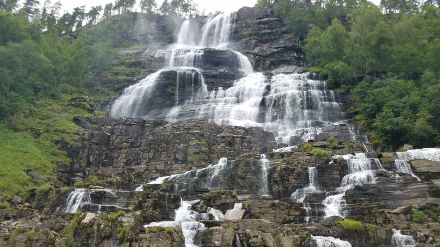
Continuing down the E16, located about 12.5 km (7.75 mi) North of Voss, is the Tvindefossen. These falls are located right along the highway and have a turnoff and gift shop for all the tourists who stop along the to and from Voss. In the late 1990s, Tvindefossen acquired a reputation for rejuvenation and revival of sexual potency that made it one of the most important natural tourist attractions in western Norway.
Now it was time for some fun. Voss is known for its adventure activities. Most people would think it’s where the expensive bottled water comes from, but it’s not. The water may be named after this area or the mountain, but the water actually is bottled in Iveland (Southern Norway), which is over 400 km (250 mi) from Voss Mountain. The town of Voss is 50 km (31 mi) from Voss Mountain.
Moving on, the reason for coming to Voss was to go Indoor Skydiving at Vossvind! If you’ve never gone before (any indoor skydiving), you must. It is expensive for the limited time you get in there, but it is so much fun. Watch my videos below (from 2 different viewpoints). For more pictures and videos, check out my album on Facebook or check out my YouTube channel.
Bergen
We arrived in Bergen and went straight to Det Hanseatiske Hotel to check in. The Hanseatic Hotel is a beautiful hotel just a short walk from the city’s attractions. The hotel is a part of Finnegaarden at Hanseatic Wharf, Bryggen in Bergen, which is inscribed on Unesco’s list of World Heritage Sites. The hotel has free WiFi, the room had a great en-suite bathroom, that was about the same size as the bed area. We were on the top floor of our building, so the ceiling slopes down to the foot of the bed and there are numerous skylight windows for air. It was a really nice stay for the few nights we stayed in Bergen.
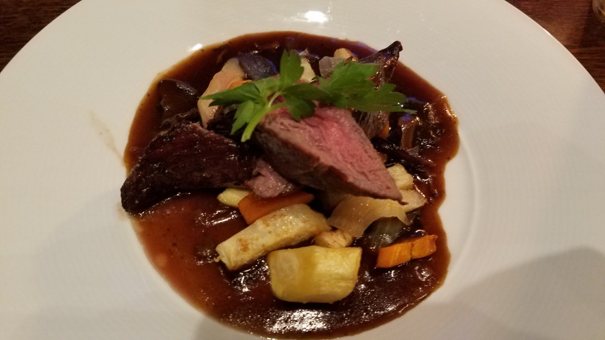
Since we had been camping so much and eating sandwiches and small meals at the campsite, once we got to Bergen, we splurged for fancier meals. This is when you really learn how expensive Norway can get. It was pretty late when we arrived, so choices for dinner were limited, but just 1 block away, we found Bryggeloftet & Stuene, which was still open for another hour and a half. We both ordered the steamed muscles appetizer (which we should have shared because there were so many), the fillet of reindeer for main, and each got a different dessert, which we shared, and some non-alcoholic drinks. The food was absolutely amazing and very much-needed after all the camping meals. That is until the bill came. Total for the 2 of us was 1,500 NOK ($190.00)!!!! It was sooooo good though. This is not the most expensive country in the world for nothing. They’ve certainly earned that title.
Some of the other places we ate were Deli de Luca, Espresso House, and Kaffelade. All had very good food and drinks.
Attractions we visited were Fløibanen (Funicular) and Fløien Utkikkspunkt (Fløien Lookout Point), Bryggen UNESCO World Heritage Site, Håkonshallen, Fisketorget, and the Torgallmenningen (main square) of Bergen.
The Fløibanen is the only Funicular (a cable railroad, especially one on a mountainside, in which ascending and descending cars are counterbalanced) in Norway and it takes you up the mountain to the Fløien Utkikkspunkt (Fløien Lookout Point), for beautiful panoramic views of the city of Bergen. At the top there is a restaurant (cafeteria style), function rooms, goats (to keep the grass and bushes trimmed), zip lines for the kids, hiking, biking, and other activities depending on the time of the year. Round trip on the Fløibanen was 90 NOK ($10.75) per person.
Walking around the UNESCO World Heritage Site where only around a quarter of the original buildings that existed in Byrggen remain after demolitions at the turn of the 19th century and several fires in the 1950s. The medieval urban structure is maintained and the buildings include all elements necessary to demonstrate how Bryggen functioned with offices and dwellings at the front, warehouses in the midsection and assembly rooms, kitchen facilities, and fireproof stone cellars at the back.
The area around the Bergenhus Festning (Fortress) includes many sites such as Håkonshallen (King Håkon’s Hall), Kommandantboligen (Commandant’s residence), Bergenhus Festningsmuseum (Bergenhus Fortress Museum), and the Rosenkrantztårnet (Rosenkrantz Tower). The sites date as far back as medieval times and have been renovated over the years. Inside there are some things to play with as helmets, swords, shields, etc. and many rooms to check out. It’s a good place to kill a few hours while seeing some of the old royal buildings in Bergen.
The Fisketorget (Fish Market) is located at the end of the Quay and has tons (literally) of fresh seafood every day. You can find more than seafood at the market as it is more of a ‘Farmer’s Market’, but there is definitely plenty of seafood.
The Torgallmenningen (main square) of Bergen is lined with numerous shops and restaurants and is the main meeting spot for most people in the city, specifically at Den Blå Steinen (The Blue Stone), which is the popular meeting spot in Bergen and is a public artwork that is a large sloping slab of stone with a blue-hued coating.
For more pictures and videos, check out my album on Facebook or check out my YouTube channel.
Bergen to Haugesund
The next stop on our adventure is Haugesund, which is located about 3.5 hours south of Bergen. In the Haugesund area, we stopped at the Dei Fem Dårlege Jomfuer (The Five Bad Virgins) Stones, Olavskirken (Olav’s Church / Avaldsnes Church), and The Viking Village on Bukkøy Island before checking in to the Radisson Blu Hotel – Haugesund for the night. The hotel was a standard Radisson Blu and was very comfortable, had a spacious room, free WiFi, and free breakfast.
Dei Fem Dårlege Jomfuer (The Five Bad Virgins) Stones is a set of five high memorial stones in a star-shaped stone setting. Inside the stone setting lay a grave from the Late Roman period. Tradition says that this star shaped stone setting is part of a religious / magical calendar system. The triangular shape is a symbol of the female, while the actual memorial stones are a phallic symbol. Saint Olav often traveled around the country to Christianize his people. One time he came from the north and was going to the royal estate at Avaldsnes. When he arrived, he saw five playful girls standing on the mainland side and waving at him. But the king allowed himself no endeavor and he cried aloud “Now, stand there and turn to stone, until I come back.” Immediately the virgins were turned into stone. Still they are standing there, by the Karmsund, looking across the strait to the Olav’s church at Avaldsnes.
Olavskirken (Avaldsnes Kirke) dates back to 1250 AD and was built by King Håkon Håkonsson. One of the legends of the church claim that doomsday will come when the Virgin Mary’s Sewing Needle (a 7.3 m / 23.9 ft tall stone that leans towards the church’s Northern wall) touches the church wall. In the past, priests at Avaldsnes have climbed up the stone and chipped pieces from the top, saving the world from destruction. Today the gap between the doomsday stone and the church wall is around 9.2 cm (3.6 in). The church was locked when we got there, but on our way out from the Viking Village, someone was inside practicing the organ, so we were able to sneak in for a couple of minutes to take a look and get some pictures.
The Viking Village on Bukkøy is a replica viking village with period actors that offer tourists the chance to see what Viking life may have been like. I was honestly expecting to see the remains of a real Viking settlement, so was disappointed. The village may be more fun for families with children though.
For more pictures and videos, check out my album on Facebook or check out my YouTube channel.
Haugesund to Stavagner
Next on the itinerary is Stavanger, located about 2 hours South of Haugesund. We checked out some of the attractions on Karmøy, Klosterøy, and Fjøløy Islands before getting to Stavanger. These included some Viking Burial Mounds (Gravhaugane på Reheiå), Visnes Miningsite (Old Copper Mine at Visnes), Åkrasanden (one of Norway’s biggest and nicest beaches), Karmøy Fishermen’s Memorial, Skudeneshaven, Utstein Monestary, and the Fjøløy fast (Fjøløy fort). In Stavanger, we stayed at the Scandic Stavanger City Hotel. We chose this hotel because it was very close to the ferry terminal which we had to get on the morning ferry. The room was very comfortable, there was free WiFi throughout the hotel, and breakfast was included. The location of the hotel is convenient for the ferry, but is about a 20 minute walk to the main restaurant street of Skagen, which is close to the cathedral. Parking is available on site, if you arrive in the evening and will have the car out by 08:00 AM. We opted to park 750 m (0.5 mi) down the main road at the 24 hr parking garage.
First stop was at some Viking Burial Mounds (Gravhaugane på Reheiå) along the road. One of the mounds date back to the early Bronze Age (1300-1100 BC). Inside the mound was a skeleton, bronze sword, dagger, spear point, and two buttons. In another mound, an excavation found a broken bronze sword, a gold bracelet, and small pieces of gold leaf. The bracelet dates back to 1100 BC, is 6.5 cm (2.55 in) in diameter, 22 carat gold, and weighs 22 grams. Outside the mounds are standing stones
Visnes Miningsite (Old Copper Mine at Visnes) was the largest mine in Northern Europe in the 1880s and was extracting copper, zinc, and sulphur. Fun fact about the mine is that copper from Visnes was used to clad the Statue of Liberty in New York City. The site even has a miniature Statue of Liberty to commemorate this little known fact.
Åkrasanden is considered one of Norway’s biggest and nicest beaches (voted as such in 2014). Many visitors have been surprised by their first walk along Åkrasanden Beach as, during the summer months, it has a Mediterranean atmosphere, with the long and beautiful white sand beach glistening beside the crystal clear water in the shallow bay.
Karmøy Fishermen’s Memorial is located just a few kilometers south of Åkrasanden Beach and was erected to preserve the memory of the local fishermen who died at sea. There are many different types of rocks in the area around the memorial that get left on the shore by the sea. We scoured the area for about 45 minutes and found some really nice rocks that don’t look like any of the others in the area.
Skudeneshaven’s old town (Gamle Skudeneshavn), consisting of 225 wooden houses, is regarded as one of the best preserved in Europe. Most of the buildings are painted white and have orange roofs. All the streets are extremely narrow and look the same no matter which direction you turn. The old town is really pretty though. We were fortunate to be there on a beautiful sunny day, so the white buildings, orange roofs, blue skies, deep blue water, all made for an amazing view.
At the end of the small old town is a park that has a few attractions that tourists flock to see. Specifically the Moon Stone and the Yes or No Bench (Ja/Nei Benken).
The Moon Stone is a rather odd-looking, porous stone that is perched among some other larger rocks. Local explanation was that the rock was perhaps a meteorite that landed in the park, but a geologist has analyzed the stone and found it was 800 million years old and similar to a type of stone found in some valleys in Eastern Norway. Most likely the rock was brought by glaciers more than 10,000 years ago, during the Ice Age.
The Yes or No bench is a set of 2 benches on top of some rocks that overlook the harbor. If a man asked a woman for her hand in marriage, she would either sit in the Ja (Yes) bench or the Nei (No) Bench. The sign for the bench shows a couple embracing in a heart for the Ja bench and a couple sitting apart outside a broken heart for the Nei bench.
Utstein Kloster Monestary is an Abbey that was built in the latter 1200s and has been listed a historical monument by Royal Decree of 19th December 1999. This decree includes all of Klosterøy Island, Klostervågen, Fjøløysundet, and the northern part of Fjøløy, a total of 2500 decares (2.5 km² / 617.75 ac). The abbey is mentioned in records going as far back as the 9th century as a royal garrison and farm. Unfortunately for us, we arrived after the museum was closed, so we were unable to go inside. We did get to tour the ground though and get some great photos with no other people around.
Fjøløy fast (Fjøløy fort) is an old fort built in 1941 at the height of WWII, but was never finished. The fort was used off and on throughout the years and is now a tourist area. Tourists can hike around the fort and even stay in cabins scattered around the property.
In Stavanger we had dinner at XO Steakhouse. Here we were treated to some live music (in English), a great atmosphere, and some even better steaks. We ordered the 400 g (14 oz) beef tenderloin, wrapped in bacon, served with pepper sauce, and hand cut fries. I would definitely recommend a visit to XO Steakhouse if you’re in Stavanger. There are certainly plenty of places to choose from in the immediate area as well, but for a great steak, this is your place.
For more pictures and videos, check out my album on Facebook or check out my YouTube channel.
Stavagner to Kristiansand
One of the big items I wanted to do while in Norway was on tap for today. We woke up early, filled up on breakfast, caught the ferry to Tau before driving to Preikestolen, otherwise known as Pulpit Rock. In a twist of fate, since we’ve had amazing weather for the whole trip up to this point, mother nature decided a day of hiking in Norway just wouldn’t be the same unless it was raining.
We arrived at the parking lot to start the hike and caught a break in the weather. It was still overcast and windy, but the rain had stopped, for now. We grabbed our rain gear, bags, and water, and started up the 3.8 km (2.4 mi) trail with a large number of other tourists going in both directions. The walk to Preikestolen is very steep in places. The path starts at the Preikestolhytta, at an elevation of approximately 270 m (890 ft) above sea level and climbs to 604 m (1,982 ft). The hike takes 1–3 hours depending on traffic along the trail, experience, and fitness level. Even though the elevation differential is only 334 m (1,096 ft). The total elevation gain and loss over the course of the hike is more than one might initially expect, as the path climbs and descends various ridges. We managed to get up the trail in 1 hr 45 minutes and back down in 1 hour 20 minutes.
Once we arrived at the top, there were quite a few tourists waiting to have their picture taken, but then the wind picked up and it got cold. Within 5 minutes, most tourists had disappeared around the side of the hill to stay out of the wind. Some of us stayed behind to enjoy the lack of people and take some great photos while trying not to be blown off the cliff to the fjord 604 m (1,982 ft) straight down. The silver-lining to the weather was having Pulpit Rock essentially to ourselves.
After conquering Preikestolen, we headed to Orrestranda, which is, at nearly 5 km (3.2 mi) in length, Norway’s longest sandy beach. With its light, fine-grained sand, this beach is reminiscent of the sandy shores found in warmer climates. People come here to swim, surf, and hike in the fresh sea air. When we arrived, it was raining and very windy, but we found people still surfing the rough waves.
We continued to drive along the coastal road of 44 until it connected back with the E39 and finished our day very late at night in Kristiansand. Since it was raining, we decided against camping and checked into the Hotel Norge (Best Western Plus). We were able to secure the last room and the last available parking spot in the hotel garage. This garage is attached to the hotel but only has room for 8 or so cars in extremely tight spaces. I had to let my friend out and unload all our stuff before backing in to the space where I could barely open the driver’s side door enough to slip out of the car. I had to walk around the back of the car because the front was so close to the pole and wall that I couldn’t get through without climbing on the car. The passenger’s side was not much better with only 25 cm (10 in) to slide along the car (less between side mirrors). The room was what I expected of a Best Western chain hotel. Not super nice, but adequate for a night’s sleep. WiFi was free throughout the hotel, the shower was nice and hot, and the bed was rather comfortable after being in the car and hiking all day. Since we arrived so late, it was showers and then to sleep for another long day of driving tomorrow. Free breakfast was included in the morning, so we filled up before heading out.
For more pictures and videos, check out my album on Facebook or check out my YouTube channel.
Oslo
After breakfast, we took our gear to the car, packed up, and headed out. Today was the last 4 hour drive back to Oslo, where this adventure started 3 weeks earlier. The weather was beautiful and the drive was going well… for a while. Along the route, we came across a section of the highway that was under construction and they were blasting rock. This cause a 3 hour traffic delay to get by it. One thing about Norway is most of the main highways outside of Oslo are single lane each way and are heavily traveled as they are the quickest route between areas. Heavy traffic, single lanes, and the risk of an accident or road/tunnel closures can quickly create very lengthy delays. Luckily we had no plans for the day other than to get back to Oslo and do some laundry, so we rolled along very slowly for the 7 hours back to Oslo.
The next day Edda took me on a tour of Oslo. We waked all over the city and visited many sites including Vigelandsparken (The Vigeland Park), Det Kongelige Slott (the Royal Palace), City Hall, Parliament, the Opera House, and the Nobel Peace Center. We could also see the Akershus Fortress across the harbor.
We had dinner at Sørenga Sjømat, which is a seafood restaurant located on the waterfront of the Bjørvika harbor in the Sørenga neighborhood. We sat outside on the patio and enjoyed some good seafood. The patio was nice except when groups kept coming out to smoke just outside the patio area. Since the restaurant is on the water, the breeze blows all the smoke back into the patio area, which neither of us were happy about. The food arrived in a reasonable amount of time, was hot, and tasted good, but was quite expensive. Not as much as the meal in Bergen, but we did not have any desserts here and it was still 900 NOK ($114.00) for the 2 of us.
Vigelandsparken (The Vigeland Park) is the world’s largest sculpture park made by a single artist, and is one of Norway’s most popular tourist attractions. The park is open to visitors all year round. The unique sculpture park is Gustav Vigeland’s lifework with more than 200 sculptures in bronze, granite and wrought iron. The Park was mainly completed between 1939 and 1949. Most of the sculptures are placed in five units along an 850 m (0.53 mi) long main path: The Main gate, the Bridge with the Children’s playground, the Fountain, the Monolith plateau, and the Wheel of Life. One of the most famous statues for people to take a picture with is Angry Baby, which is a bronze statue of a nude baby stomping his foot with an angry look on his face. The park is beautiful and the sculptures are amazing. Definitely worth a visit if you’re ever in Oslo.
Det Kongelige Slott is the Royal Castle of Norway and is situated on a rise, the Bellevue, at one end of Oslo’s main thoroughfare, Karl Johans gate. The Royal Palace is owned by the state and placed at the disposal of the head of state. It is where the daily work of the monarchy is conducted and where the King and Queen live. It is where the King presides over the Council of State, grants audiences and holds official dinners. Foreign heads of state who visit Oslo stay at the Palace and most of the members of the Royal Court have their workplace here.
City Hall houses the city council, city administration, and art studios and galleries. Its characteristic architecture, artworks and the Nobel Peace Prize ceremony makes it one of Oslo’s most famous buildings. The roof of the eastern tower has a 49-bell carillon which plays every hour.
Parliament houses the offices of the parliament and the Norwegian government functions out of this building.
The Opera House has an angular design that seemingly arises from the waters of Oslo Fjord and is considered the keystone signature of the Oslo Opera House. The architect firm wanted make the roof a platform accessible to all and create a new public space in the center of Oslo. You can find many people walking, sitting, or even skateboarding on the marble roof ramps. A parallel wish was to create a new landscape that would draw together the natural beauty of Oslo Fjord and the city. In the foyer the public is met by a light, open space with a large wood wall. Behind this wall are the opera house’s three performance halls, with the Main House forming the heart of the building. Acoustic requirements determined the interior design of the Main House, and the combination of timber and tonal possibilities and the dark, golden woodwork can be said to have transformed the Main House into a singularly over-sized wooden instrument.
The Nobel Peace Center is the museum about the Nobel Peace Prize. The museum presents the Peace Prize laureates and their work, and tells the story of Alfred Nobel and the Peace Prize. The Center also acts as an arena for debate about important social issues.
For more pictures and videos, check out my album on Facebook or check out my YouTube channel.
Last stop is Oslo Airport (OSL) for my flight to Dublin on Norwegian Airlines. Oslo airport is located about 45 minutes drive N.E. of Oslo on the E16. I was dropped off by Edda, but you can take a train from Oslo Central Station to the Oslo Lufthavn (Airport) stop as well. The journey takes about 23 minutes and is only 2 stops. Getting through the airport in Oslo was very quick and efficient. Norwegian Airlines has you get your own baggage tags and check your baggage through kiosks, so there is not usually a wait to check in. Security was also very quick with multiple lines available and not wait at all.
Although Norway is the most expensive country on Earth, it may also be the most beautiful. There is so much to see and do there and not nearly enough time or money to do it all without living there.
Thanks, Edda, for an amazing trip around your country!!
I hope this gives you some inspiration to take a trip to Norway. For photos from the entire trip, check out all my albums on Facebook and my YouTube channel.
Please share with your friends using the links below. If you have any questions or comments, please reply using the box below.
Thanks for reading!
