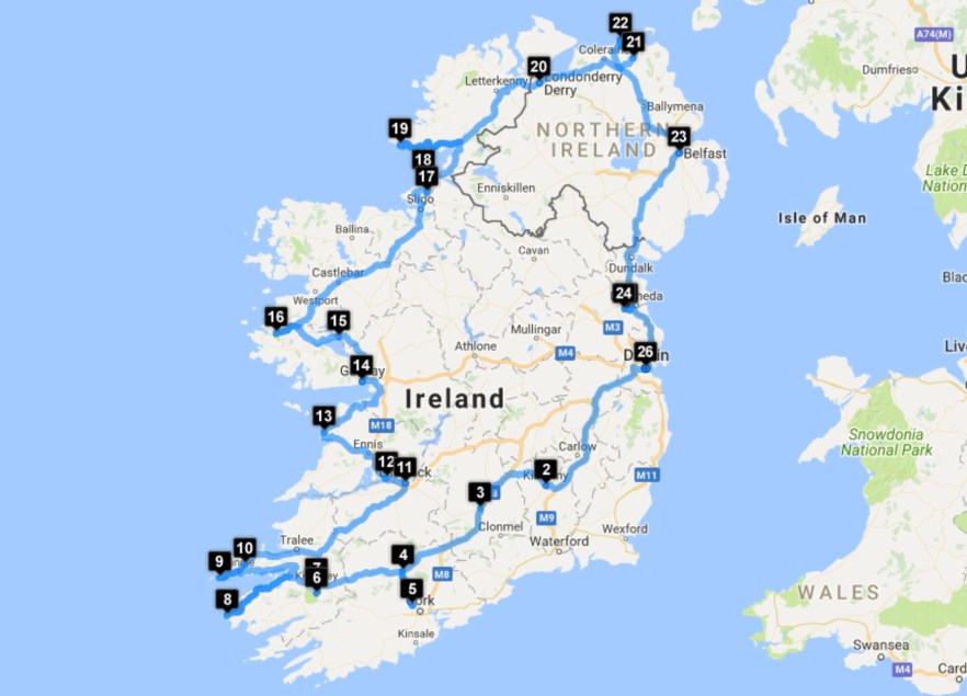
Length: 10 days (8 in Ireland, 2 in Northern Ireland)
Tour Company: Over the Horizon
Tour: Ireland and Northern Ireland Self Guided
Traveler: Dave
Places visited:
1 – Dublin, Ireland
2 – Kilkenny, Ireland
3 – Cashel, Ireland
4 – Mallow, Ireland
5 – Blarney, Ireland
6 – Torc Waterfall, Ireland
7 – Killarney, Ireland
8 – Kerry Cliffs, Ireland
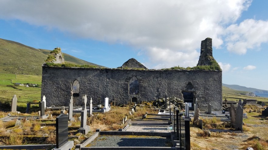
9 – Cross at Slea Head, Ireland
10 – Conor Pass, Ireland
11 – Limerick, Ireland
12 – Bunratty Castle, Ireland
13 – Cliffs of Moher, Ireland
14 – Galway, Ireland
15 – Ashford Castle, Ireland
16 – Connemara National Park, Ireland
17 – Gleniff Horseshoe, Ireland
18 – Mullaghmore Beach, Ireland
19 – Slieve League, Ireland
20 – Londonderry, UK (See UK – Northern Ireland – August 2017)
21 – The Dark Hedges, UK (See UK – Northern Ireland – August 2017)
22 – Giant’s Causeway, UK (See UK – Northern Ireland – August 2017)
23 – Belfast, UK (See UK – Northern Ireland – August 2017)
24 – Newgrange, Ireland
25 – Brú na Bóinne, Ireland
26 – Dublin, Ireland
After a 2.5 hour flight from Oslo, I arrived on the Emerald Isle at the Dublin Airport. Located 20 minutes N of Dublin center, the airport is reachable by car/taxi, or via public transportation in 25 to 30 minutes.
Customs took a little while to get through as the agents ask numerous questions about your stay and especially when you’re leaving. Proof of onward travel is required in a lot of countries and I’ve been asked when I was leaving, but I’ve not actually had to present the documentation to the customs agent. Usually I just tell them the date and good enough. I heard the agent asking a group of girls ahead of me for their paperwork, which they didn’t have, but were able to get on their phone. I was in the same situation as I didn’t print anything since I booked this part of the trip while on the road in Norway. I was able to get my flight confirmation from the Ryan Air app on my phone before I got to the window though, so that saved me some time. Be prepared to answer a lot of questions and provide proof when entering Ireland.
I rented a car since I was doing a road trip of Ireland and Northern Ireland. I chose to rent a car through Avis, but had a hard time with the woman at the counter. She wouldn’t let me take the car without purchasing insurance through them, even though I had insurance through my credit card and through my travel insurance for rental car collision damage. I had no choice but to add it and deal with it later. I got a Peugeot 2008 which is a compact SUV, Diesel, 5 Speed, had plenty of storage space, and was really nice. The first 10 minutes of driving was getting used to the right hand drive, left hand shift that is standard in the UK and Ireland. After that it was smooth sailing through the cities and countryside. I was able to talk to Avis customer service in the US when I got home and explained the situation to them (and that I wasn’t forced to get the full insurance in Scotland), they were able to refund my for the extra insurance that I did not want.
I used Booking.com for all my overnight stays in Ireland and Northern Ireland, except the last night at the Hilton Dublin Airport, where I used Hilton points.
For mobile phone service in Ireland, I was still using my Telia Norway SIM card as I had over 2 GB of data left and with Europe’s “Roam like you’re at home” policy, I was able to use it all over Ireland. I did, however, pick up a 5 GB Vodafone card while in Dublin for when my Norway card ran out, as the Vodafone card would work for the rest of my time in Ireland and the UK and I wouldn’t have to worry about being without. The 5 GB plan cost €30.00 ($37.50) and is good for 30 days.
Vodafone IE APN settings:
Name: IE – Vodafone (live.vodafone.com) Web
APN: live.vodafone.com
Proxy:
Port:
Username: <blank>
Password: <blank>
Server:
MMSC:
MMS Proxy:
MMS Port:
MMS Protocol: WAP 2.0
MCC:
MNC:
Authentication Type: PAP
APN Type: default, supl
Another useful thing in Ireland is the Heritage Ireland Card. This card can be purchased at many of the heritage sites for €40.00 ($50.00) and will get you free or reduced entry to many locations throughout Ireland. Refer to the link above for the list of locations, entry fees, and where to get the card. I bought my card at the Rock of Cashel and used it at multiple locations. I wish I had known about it sooner as I had already visited (and paid entry) to some of the sites that would have been free with the card. See link below for a list of the sites, including where to buy the card, which sites are free, and entry fees as of August 2016 (which is most valid on their website at the date of writing this).
Sites who sell Heritage Cards August 2016
Dublin
First stop was the Paramount Hotel, which was a bit hard to get to by car (no parking in front of the hotel), but luckily I was able to call them and get directions to the parking garage they use, Christchurch Car Park, 500 m (0.3 mi) away. Once I parked there, I gathered all my baggage and walked to the hotel. The hotel does validate parking for a better daily rate, so be sure to get the ticket stamped if you stay here with a car. Located in the Temple Bar area of Dublin, it is a great location to walk to everything. The windows in the hotel room offer almost no relief from the noise outside. I was on the 2nd floor (3rd if counting the lobby) and it sounded like every person walking by the hotel was having a conversation the room, but luckily I was there on Sunday and Monday nights, so the noise could have been much worse if it were on the weekend. In addition to the windows not providing any relief from the noise, the door to the room was no better. My room was right next to the stairwell and the elevator, and had a constant flow of people going by at all hours of the night. Thankfully, I travel with ear plugs and that helped me sleep. The bed was comfortable, the shower was hot, and the WiFi was free and working, so it was all I really needed for a few nights in Dublin.
A few of the places I visited for food and drinks in Dublin were:
Bison Bar & BBQ is a Memphis Style BBQ and St. Louis Style Ribs restaurant and bar located along the South side of the River Liffey on Wellington Quay, between the Grattan Bridge and the Millennium Bridge. I pulled up to the bar and ordered my first pint of Guinness in Ireland as I checked over the small menu. Halfway through my pint, I settled on the combo plate (2 meats and 2 sides) with the smoked brisket and pulled pork with potato salad and burnt end beans. It was fantastic. The brisket didn’t need to be chewed, as any proper smoked brisket shouldn’t, and the pulled pork was soft and flavorful. The burnt end beans were hot and had a little spice to them and the potato salad was cool, creamy, and delicious. Well done, Bison Bar & BBQ.

Smoked brisket and pulled pork with potato salad and burnt end beans
1837 Bar & Brasserie is one of the restaurants located on the 5th floor of the Guinness Storehouse. 1837 offers a small, but varied menu and most importantly, fresh Guinness. Since it was lunch time, and I’d already been through the brewery tour on an empty stomach (including multiple tastings and pints while getting my certification for the perfect pour), I needed some food. I opted for another pint of Guinness and the Prime Guinness Beef Burger, skin on chips, Guinness chutney, bacon, and cheddar cheese. The burger did its job and helped me through the rest of the day.
The Quays Irish Restaurant is exactly what it sounds like, a traditional Irish restaurant. The Quays is located on Temple Bar, directly across from the Temple Bar Square and has an upstairs and downstairs (street level) and can be extremely busy. I hear wait times up to 45 minutes while I was eating. They specialize in traditional Irish dishes like Irish Stew, Famous Wicklow Lamb Shank, Dublin Coddle, Cottage Pie, and Slow Cooked Beef and Guinness Stew. They also serve Tender Juicy Steaks and a wide range of Seafood and Vegetarian options. I decided on the slow cooked beef and Guinness stew, with chips, and brown bread. The stew was extremely hot and packed with flavor and the chips were crisp and perfect.
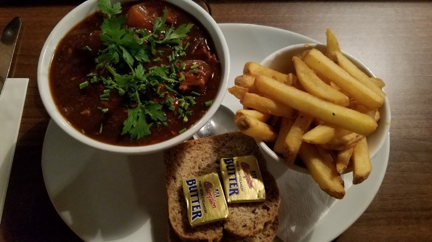
Slow cooked beef and Guinness stew, with chips, and brown bread
Dublin attractions that I visited:
The Ha’Penny Bridge opened in May 1816 to offer passage to any Dubliner willing to pay a ha’penny, the exact price of the then redundant ferry and payable to William Walsh, ferry owner and alderman of the city. He retired his leaking ferries and was compensated with £3,000 and the bridge lease for one hundred years. It is the first pedestrian bridge to cross the Liffey and was a welcome relief for Dubliners accustomed to crossing other bridges with horses, carriages, and carts before any pedestrian lanes existed. It was the only pedestrian bridge to span the river until the opening of the Millenium Bridge in 1999. It is known as the Ha’penny Bridge, in reference to the old toll, but has officially been named the Liffey Bridge since 1922.
For more pictures, check out my album on Facebook.

Ha’penny Bridge
The Spire is a 120 m (394 ft) high, 3 m (10 ft) in diameter at the base tapering to 15 cm (6 in) in diameter at the top, monument in the middle of O’Connell Street, just across from the General Post Office (GPO).
For more pictures, check out my album on Facebook.

The Spire
The statue of Molly Malone and her cart is affectionately nicknamed “The Tart with the Cart” by Dubliners. Molly Malone was a semi historical/legendary figure, who was commemorated in the song “Cockles and Mussels”. She worked as a fishmonger and a working girl and died in one of the outbreaks of cholera. Her chest is less dull because of all the people who touch her while having their picture taken.
For more pictures, check out my album on Facebook.

Molly Malone Statue
The Guinness Storehouse is the home of my favorite beer, a true pint of perfection. On December 31, 1759, Arthur Guinness signed a 9,000-year lease on a small, disused, and ill-equipped property at St. James’s Gate and started to brew ale. Still located in the St. James’s Gate Brewery, the Guinness Storehouse is Ireland’s most popular tourist attraction. The tour begins at the bottom of the world’s largest pint glass and continues up through seven floors filled with interactive experiences that fuse their long brewing heritage with Ireland’s rich history.
Entry to the Storehouse was €17.50 ($22.00) for online, but it’s €25.00 ($31.25) for walk-up. The line can be long, so it is better to purchase your ticket online. You can pick any available time online and I actually purchased mine while I was in line and was able to get out of the main line and pick up my ticket at the kiosk rather than waiting. It takes about 15 minutes for the online order to be ready for pick up at the kiosk and the line was about 30 minutes, so it worked out for me. If you enjoy beer, it’s a great place to tour the whole beer-making process and of course enjoy many pints of fresh beer.
For more pictures, check out my album on Facebook.
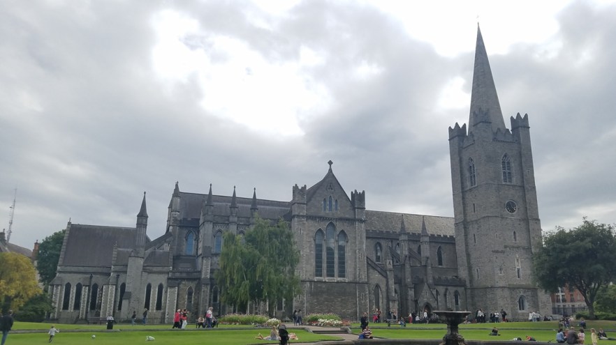
St. Patrick’s Cathedral has been part of Ireland’s history for over 800 years and is one of the most popular visitor attractions in Dublin. Built in honor of Ireland’s patron Saint between 1220 and 1260, Saint Patrick’s Cathedral is one of the few buildings left from medieval Dublin. It is the National Cathedral of the Church of Ireland and is the largest Cathedral in the country. The Cathedral is world-famous for its choir which still performs daily during school term. I enjoy the architecture and details of medieval and Gothic style cathedrals, so visiting was a must for me.
Entry to the cathedral was €7.00 ($8.75) and there can be a line to get in. Guided tours of the Cathedral happen regularly throughout the day or a free App can be used for self-guide purpose.
For more pictures, check out my album on Facebook.
St. Patrick’s Cathedral
Dublin Castle is one of the most important buildings in Irish history. From 1204 until 1922 it was the seat of English, and later British rule in Ireland. During that time, it served principally as a residence for the British monarch’s Irish representative, the Viceroy of Ireland, and as a ceremonial and administrative center. The Castle was originally developed as a medieval fortress under the orders of King John of England. It remained largely intact until April 1684, when a major fire caused severe damage to much of the building. Despite the extent of the fire, parts of the medieval and Viking structures survived and can still be explored by visitors today.
The new building includes a suite of grand reception rooms known as the State Apartments. On January 16, 1922, the last ever Viceroy of Ireland handed Dublin Castle over to Michael Collins and the government of the newly independent Irish state. The end of the British presence had come about in the wake of the Easter Rising of 1916 and the Irish War of Independence. These momentous events paved the way for the creation of the Republic of Ireland and were closely associated with the history of Dublin Castle. Since 1938, each one of Ireland’s presidents has been inaugurated in St Patrick’s Hall, the grandest of the State Apartments.
Personally, I find the State Apartments in most castles to be over-the-top and they’re not my favorite. I really enjoyed the Viking Excavation under the castle and the Chapel Royal. The chapel is small, but the details are exquisite. Everything looks like stone, but is actually wood that has been carved and painted to look as if it were stone.
Entry to the castle was €10.00 ($12.50) for a guided tour (approximately 70 minutes and include the State Apartments, the Viking Excavation, and the Chapel Royal) or €7.00 ($8.75) for self-guided access (access to State Apartments and exhibitions only).
For more pictures, check out my album on Facebook.

Dublin Castle
Christ Church Cathedral has been dated to around 1028. The first bishop of Dublin and Norse king of Dublin founded the original Viking church. By 1152 it was incorporated into the Irish church. Following the capture of the city in 1170, the Hiberno-Norse cathedral was replaced with the Romanesque, and later Gothic, cathedral, parts of which survive today. In 1562, the nave roof vaulting collapsed, the cathedral was in ruins, and emergency rebuilding took place immediately. This temporary solution lasted until the 1870s. The cathedral as it exists today is heavily Victorianized due to the extensive restorations and renovations carried out between 1871 and 1878 at the expense of a Dublin whiskey distiller, Henry Roe, who gave £230,000 (€35,000,000 / $49,940,000 today) to save the cathedral.
Beneath the cathedral is a medieval crypt, the largest in Ireland, and the earliest surviving structure in the city. The crypt houses priceless silver, the cat and the rat, the cathedral shop, and Ireland’s first copy of the Magna Carta. Christ Church Cathedral was once a major pilgrimage site, and would have housed an important collection of relics ranging from a miraculous speaking cross to a piece from the crib of Jesus. A mummified cat and rat are the most unusual inhabitants of the crypt, but also the most popular. They are known locally as “Tom & Jerry”.
Entry to the cathedral was €7.00 ($8.75) for self-guided and €11.00 ($13.75) for a guided tour.
For more pictures, check out my album on Facebook.
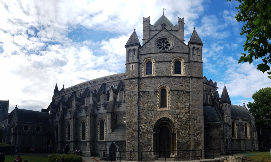
Christ Church Cathedral
Kilkenny, Ireland
Leaving Dublin, I headed S.W. on the M7 to the M9 and an hour and a half later arrived in Kilkenny (Cill Chainnigh). I parked in the Ormonde Street Car Park (Q Park), which is close to Kilkenny Castle and a great central location to walk around Kilkenny.
Kilkenny attractions that I visited:
Kilkenny Castle was built as a wooden structure in 1195 to control a crossing point of the River Nore and the junction of several travel routes. The stone castle of today was started in about 1209 and was completed in 1213. It was originally a square-shaped castle with towers at each corner. Three of these original four towers survive to this day. The missing wall and tower were blown up during a siege in 1650. The interior of the castle has a number of rooms to visit on 2 floors. The exterior has a rose garden on one side of the castle and a large park on the opposite side.
Entry to the castle was €8.00 ($10.00) and is self-guided.
For more pictures, check out my album on Facebook.
The Dominican Black Abbey was established in 1225. Originally The Black Abbey was part of a more extensive Dominican Priory and acquired its name from the Black Friars, as the Dominicans were known because they wore black cloaks over their white habits. The Black Abbey was at the center of life in Kilkenny for centuries. It was repressed in 1543, converted into a courthouse and served as such until the end of the 17th century. Partially restored in 1778, the Abbey did not become a place of public worship until the mid-19th century. The church was renovated in the 1970s to its original glory with a magnificent colored stained glass window, and there are also many fascinating statues and relics on display. The interior is dark and not overly ornate like a lot of other churches/cathedrals from the same time, but it is a beautiful work of art and architecture.
There is no entry fee to view the interior of the abbey, but donations are appreciated.
For more pictures, check out my album on Facebook.
Dominican Black Abbey
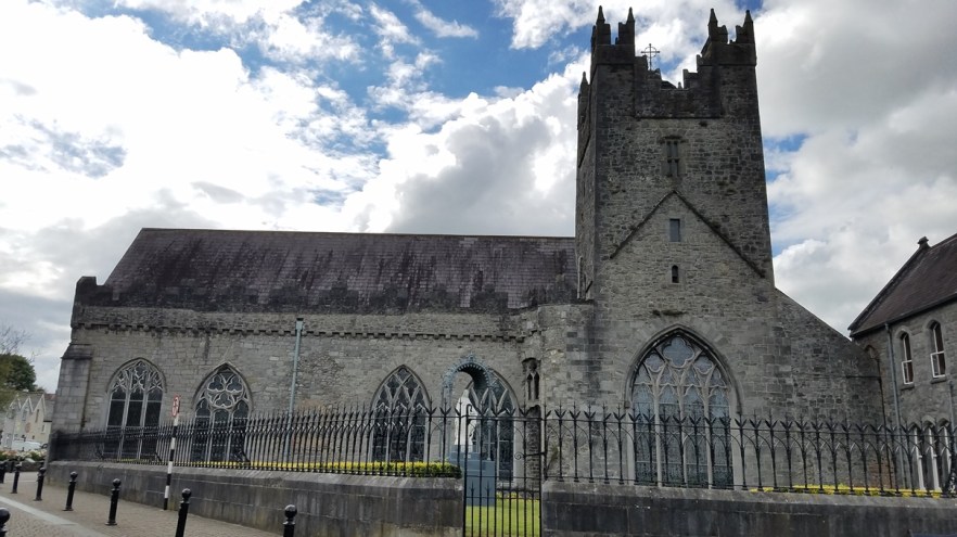
St. Canice’s Cathedral and Round Tower was founded in the 6th century and named after St Canice. Cill Channigh is Gaelic for the Church of Canice, the church that originally stood on the site in the 6th century. The Cathedral has wonderful stained glass, carved tombstones, and the See Chair of the Bishop of Ossory (dating back to 1120) can be seen inside the Cathedral. The Round Tower is the oldest standing structure in Kilkenny City. Tourists can enjoy climbing the Round Tower capturing great views of the city (weather permitting). St Canice’s Round Tower is one of only two Round Towers that people can climb in Ireland.
Entry fees were €4.00 ($5.00) for the cathedral, €4.00 ($5.00) for the round tower, or €7.00 ($8.75) for the combo ticket.
For more pictures, check out my album on Facebook.
St. Canice’s Cathedral and Round Tower
Cashel, Ireland
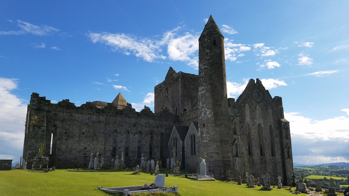
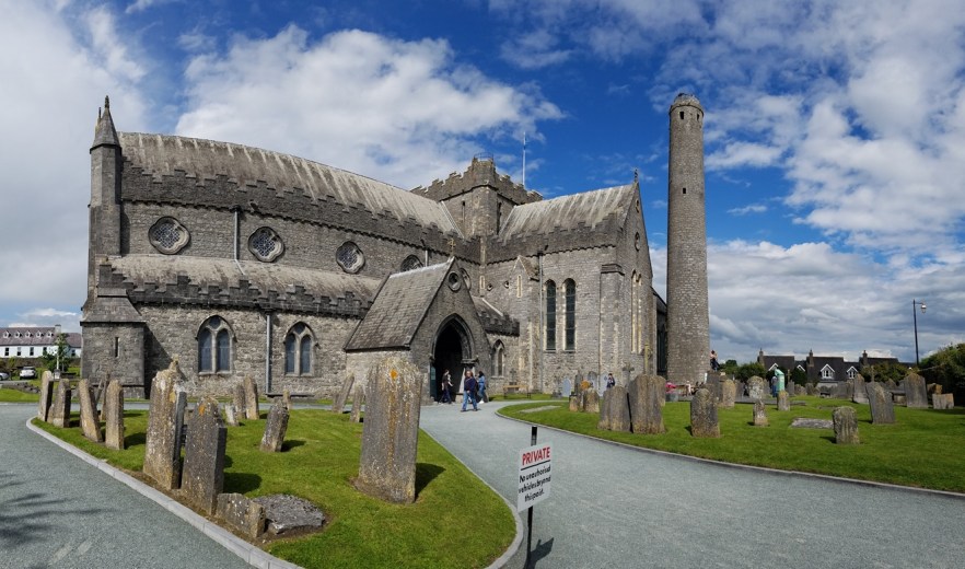
The Rock of Cashel is a collection of medieval buildings set on an outcrop of limestone in the Golden Vale. The 12th century round tower is of the oldest surviving building on the Rock, also include a high cross, and the ruins Romanesque chapel. Cormac’s Chapel is one of the earliest, and finest churches built in the Romanesque style. The 13th century Gothic cathedral is a large cruciform Gothic church, without aisles, built between 1230 and 1270. A 15th century castle and the Hall of the Vicars is the entry point to the hallowed enclosure. The Hall houses the museum where the original Cross of St. Patrick can be found.
As I stated earlier, I love seeing old churches and cathedrals, and even though this one is in ruins, it was probably one of the most beautiful structures I’ve seen. The shape and color of the building, the location on the hill overlooking a sprawling green valley, and the beautiful blue sky that opened up after a brief rain shower, all added to my visit. I was able to get some great pictures, which can be seen Facebook by clicking the link below.
Entry to the property was €8.00 ($10.00) and is self-guided. Guided tours are available, but times vary from day-to-day.
For more pictures, check out my album on Facebook.

Rock of Cashel
Following the Rock of Cashel, I headed to Mallow, Co. Cork, to the hotel for the night. I stayed in Springfort Hall, which is a 4-star country house hotel. The entrance to the hotel is a little hard to find along the narrow, tree-lined, road. I actually noticed it as I went by and had to turn around and come back. The property has free WiFi (in the public areas) and free private parking. There is an on-site restaurant which has a small, but amazing menu. Each room has a TV and my room had a separate room for the toilet and for the bath/shower. There is free shuttle service, a 24-hour front desk, a shared lounge, and a hairdresser’s at the property. I had a great, restful night of sleep and really enjoyed dinner in the restaurant.
For pictures, check out my album on Facebook.
Blarney, Ireland
Early the next morning, I checked out of the hotel and drove 30 minutes south to Blarney Castle. Blarney Castle is a medieval stronghold in Blarney, near Cork, Ireland dating from before AD 1200 and was destroyed in 1446, but subsequently rebuilt by Cormac McCarthy. It is currently in partial ruin with some accessible rooms and the battlements. According to legend, kissing the stone endows the kisser with the gift of gab (great eloquence or skill at flattery). An early story involves the goddess Clíodhna when Cormac McCarthy, the builder of Blarney Castle, being involved in a lawsuit in the 15th century, appealed to Clíodhna for her assistance. She told McCarthy to kiss the first stone he found in the morning on his way to court, and he did so. He pleaded his case with great eloquence and won. Thus the Blarney Stone is said to impart “the ability to deceive without offending”. McCarthy then incorporated it into the parapet of the castle in 1446.
The proprietors of Blarney Castle list several alternative explanations for the origins of the Stone and its supposed powers, all of which suppose that the Stone had previously been in Ireland, but was then taken to Scotland and returned to Ireland in 1314. The stories they list include:
- The Stone was the stone that Jacob used as a pillow, and was brought to Ireland by the prophet Jeremiah
- The Stone was the pillow used by St. Columba of Iona on his deathbed
- The Stone was the Stone of Ezel, which David hid behind on Jonathan’s advice, while fleeing from King Saul, and may have been brought back to Ireland during the Crusades
- The Stone was the rock that Moses struck with his staff to produce water for the Israelites, during their flight from Egypt
- In Ireland, the Stone was known as the Lia Fáil or “Stone of Destiny”, part of the king’s throne, with mysterious powers The stone’s powers were revealed to the McCarthys by a witch who had been saved from drowning.
- It is half of the original Stone of Scone, presented to Cormac McCarthy by Robert the Bruce in 1314 in recognition of his support in the Battle of Bannockburn.
Surrounding the castle are beautiful gardens. There are paths touring the grounds with signs pointing out the various attractions such as natural rock formations which have been given fanciful names, such as Druid’s Circle, Witch’s Cave, and the Wishing Steps. The castle is a popular tourist site in Ireland, attracting visitors from all over the world to kiss the Stone and tour the castle and its gardens. I arrived at 9:30 am and went straight to the Blarney Stone as the wait can be long. I waited no more than 5 minutes for my turn to kiss the stone. A souvenir photo of me kissing the stone cost €10.00 ($12.50).
Blarney House, a Scottish baronial-style mansion, was built on the grounds in 1874. It is also open to the public, but is a separate charge of €5.00 ($6.25) and has assigned tour times. Because the house is lived in by the property owners, it is only open from June 1st – August 31st, 10:00 am to 2:00 pm, Monday to Saturday.
Entry to the grounds was €18.00 ($22.50). If you bought online, entry was €16.00 ($20.00).
For more pictures, check out my album on Facebook.
Torc Waterfall, Ireland
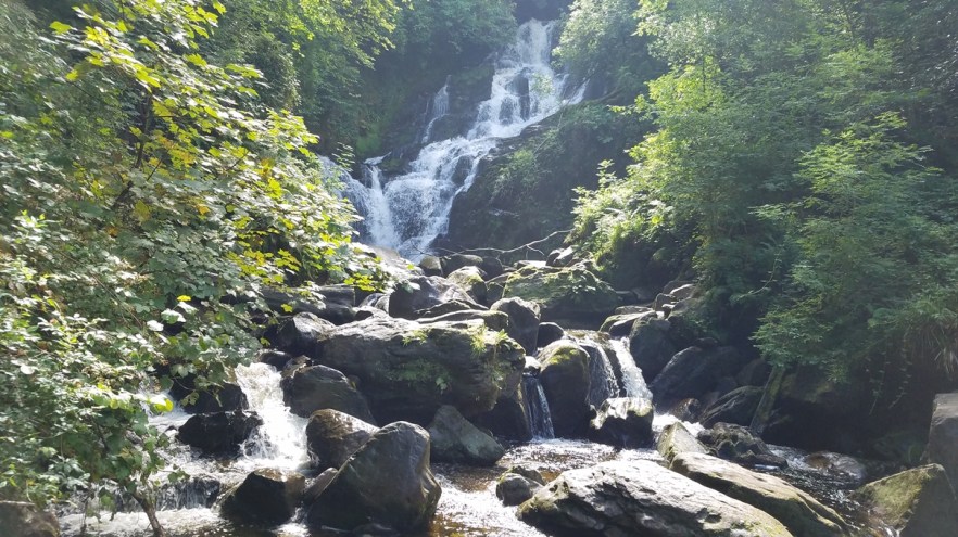
An hour and a half away from Blarney, along the Ring of Kerry, is Torc Waterfall. Torc Waterfall is best seen after heavy rains (yay Ireland!), but it must not have been raining heavily in the area before I went as the river bed in the picture below would normally be full and fast-moving. The waterfall is a 5 minute walk off the N71 Killarney Kenmare (Ring of Kerry) road through scenic woodland and is part of the Killarney National Park. The waterfall is 70 to 80 feet high and the Owengarriff river which feeds it rises in “The Devil’s Punchbowl” on nearby Mangerton mountain.
If you want a good viewing point of the lakes then climb the 100 or so steps immediately to the left of the waterfall to get some excellent views of the lakes. There are a number of trails through the park if you’d like to spend the whole day hiking from the falls. Torc Waterfall is one of Killarney’s most well-known tourist attractions and a traditional stopping point for bus and coach tours. As a result it can get busy and congested around this area in the peak summer months.
I followed Google Maps which actually takes you up a very small dirt road to Killarney Hiking Parking Lot. From this lot, you follow the trails down the hill to the falls. It is a much longer walk down, and especially back up to the lot, then it would be to park in the lot along the N71. The upper lot is just as crowded as the lower lot, so there is no advantage to going up there.
For more pictures, check out my album on Facebook.
Torc Waterfall
Killarney, Ireland
I decided to take the Ring of Kerry in a anti-clockwise direction along the N72 to the N70 and head across the Northern part of the Iveragh peninsula. At the far West end of the peninsula, I exited the Ring of Kerry onto the R565, the Skellig Ring, an 18 km (11.25 mi) loop.
Kerry Cliffs: A short drive (1.6 km / 1 mi) past Portmagee are the Kerry Cliffs. The Kerry Cliffs are similar to the Cliffs of Moher, but may be even more beautiful and are certainly less crowded as they are less known. The cliffs stand over 300 m (1,000 ft) above the Atlantic and truly offer some incredible photo opportunities, weather permitting. The Kerry Cliffs are the nearest point on the mainland from which to view the Skellig Islands (now more famous because of Star Wars: The Force Awakens and Star Wars: The Last Jedi). The cliffs have been a viewing point for generations and a few years ago were developed with fencing, a car park, coffee shop, and camping by the local landowner.
Entry to the site was €4.00 ($5.00) per person.
For more pictures, check out my album on Facebook.
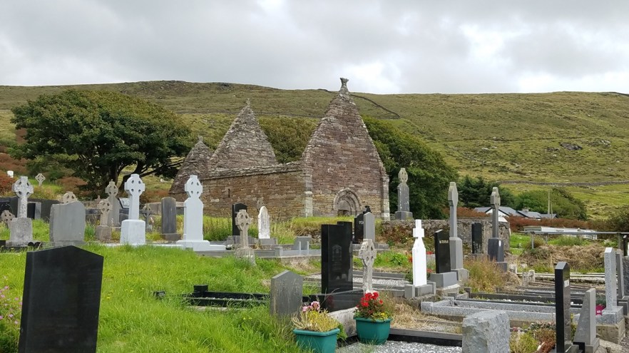
Glen Church Ruin and Cemetery: 14 minutes further along the Skellig Ring is the Glen Church Ruin and Cemetery (formerly Killemlagh Church). The Killemlagh Church ruin, which was originally built in the 12th or 13th Century on the site of St. Finian’s original monastery, is an Irish Romanesque structure and attached to it is a latter parish church. Killemlagh Church has more recently been replaced by the Glen Church that currently stands there. The church is located in a field, 270 m (885 ft) down a private, narrow, shrub lined, dirt road. I drove all the way down to the gate of the church, not realizing it was a private road or that there is nowhere to turn around. After visiting the church I had to back all the way out of there. It would be better to park along the Skellig Ring and walk to the church if you’re interested in seeing it. There is not much left of the church and the cemetery is in disrepair, but the location is beautiful with a view of St. Finian’s Bay and the Skellig Islands. I had the whole site to myself so was able to really look around and take some good pictures.
For more pictures, check out my album on Facebook.
The Glen Church Ruin and Cemetery
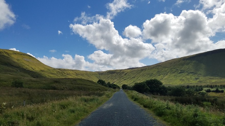
Ballaghisheen Pass: I next finished the Skellig Ring and rejoined the Ring of Kerry for 1.8 km (1.1 mi) before turning left at St. Finian’s Church (signs for Glencar) which took me through the hills in the center of the peninsula and over Ballaghisheen Pass. Ballaghisheen pass (Bealach Oisin) Scenic Drive is a stunning 1.5 hour (60 km / 37.25 mi) route from Waterville to Killarney (or vice versa) to some of the most remote and scenic parts of county Kerry. There are few equals in Ireland to this grassy plain with its broad view of the mighty Macgillycuddys. It is an alternative to Ring of Kerry drive which takes the coastal route around the Iveragh Peninsula. The landscape is a grassy plain surrounded by mountains and truly, on a sunny day, has few equals anywhere in Ireland. Near Killarney, the route skirts around the MacGilliycuddy Reeks Mountains, the highest in Ireland, and continues onto the remote center of the county to the Ballaghisheen Pass where there are amazing views east toward the Reeks and west towards Waterville and the stunning coastline.
For more pictures, check out my album on Facebook.
Ballaghisheen Pass
Greenmount B&B: Once back to Killarney, I spent the night at the Greenmount B&B. I had a little trouble finding the house, because of the number of B&Bs in the area, as well as the busy street didn’t allow for slow driving. Google Maps on my phone had the location as 100 or so meters away from where it really is. I updated Google Maps when I finally arrived, so it appears correct now. The Greenmount is a family run bed and breakfast just a 5-minute walk from the center of Killarney. It has free WiFi and breakfast. Each bedroom is includes private bathrooms and a TV. In the morning, a varied breakfast menu is available, including a full Irish breakfast. There is also a comfortable guest lounge where guests can relax with tea/coffee. There is free parking at the property and local day trips can be arranged upon request. The owner, Alice, is fantastic and very helpful. I had a great night’s stay here and would recommend the Greenmount if ever in the area.
For more pictures, check out my album on Facebook.
Killarney to Limerick
Another long day of driving was scheduled as I drove from Killarney, around the Dingle Peninsula on the Slea Head Drive, and up to Limerick for the night. I stopped at Min Aird (Minard) Castle, Dunbeg Promontory Fort, the Beehive Huts, the Cross at Slea Head, Kilmalkedar Church Ruin, went over Connor Pass, and then to the Castleroy Park Hotel, Limerick for the night.
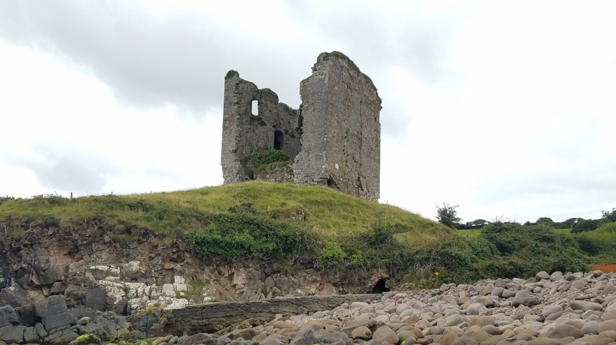
Min Aird (Minard Castle) sits on on a hill overlooking a little bay with views across the Irish Sea to the Iveragh Peninsula. It is one of only three of the mid 16th century Fitzgerald castles built on Dingle Peninsula with substantial remains. I arrived early in the morning, at low tide, and was able to walk on the beach that is normally submerged when the tide is high. There is a wall of large boulders that have been rounded by rolling on the sea floor and then deposited on the beach by the sea during storms. This natural storm beach is considered one of the finest in Ireland. The castle ruins consist of a rectangular tower house and three stories of the castle survive, but it is believed that there was a 4th story or attic space above those. The strength of this castle was demonstrated in 1650 when Cromwell’s Army detonated charges at each of it’s corners yet the castle remained. However, all occupants of the castle were subsequently killed and the structural damage done made the building uninhabitable. What is most striking about this castle is the fantastic location. The problem I encountered was that the whole property was surrounded with a wall and gates that had no trespassing signs all over them, so getting up close to the castle was not possible. It is on private land and I’m sure safety is also a concern due to the damage and it being over 500 years old. The castle is a little out-of-the-way, but worth the detour. There were only 3 other cars in the area while I was there, so not many tourists at all.
For more pictures, check out my album on Facebook.
Min Aird (Minard) Castle
Dunbeg Promontory Fort (Dún Beag) is located on a promontory between Ventry and Slea Head on Dingle Peninsula. Remains that have survived to this days were built between the 8th and 10th century, but excavations have shown some evidence of human residence dating from 8th century BC. There is no evidence that Dunbeg was ever again occupied after the early 11th century. Four ditches and five mounds protect access to the fort from the mainland, then terraced dry-stone masonry rampart with roofed entrance with two guardrooms on sides. Inside are the remains of a large, square-shaped, dry-stone hut with a water drain around. There is subterranean passage leading from the entrance in the rampart to hut. Much of the fort has fallen into the sea, due to erosion of the cliff and furious coastal storms in January 2014 (fort was closed to public for 7 months). On the rear side of Stonehouse Restaurant (across the street from the entrance of the fort) there is small visitor center where you can see audio-visual presentation about the fort. Parking is at the Stonehouse Restaurant.
Entry to the site was €3.00 ($3.75) per person.
**UPDATE** In January 2018 the site is closed to the public due to recent storms.
For more pictures, check out my album on Facebook.
Dunbeg Promontory Fort
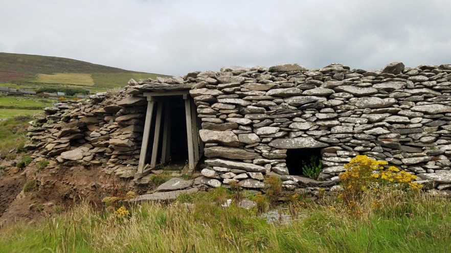
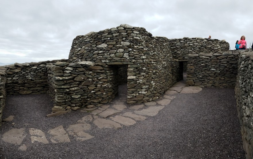
The Fahan Beehive Huts, also known as Caher Conor, are located 900 m (0.55 mi) West of the Dunbeg Promontory Fort, on the south side of Mount Eagle, to the west of Dingle Town. The Caher Conor complex consists of five structures and the huts were probably once single family dwellings, attached to each other with inter-connecting doorways. They were built in the form of a circle of successive layers of stone, each layer lying a little closer to the center than the one beneath and so on up to a small aperture at the top that could be closed with a single small flagstone or capstone. No mortar was used in building, which is called corbelling.
The hillside at one time had over 400 of these drystone, corbelled huts surviving. Dating the huts is difficult because the skill of corbelling has been used in Newgrange (3100 B.C.) and as recently as the 1950s. The huts at Fahan along the Slea Head Drive may well date to the 12th Century when the incoming Normans forced the Irish off the good land and out to the periphery of the Dingle Peninsula.
Parking is located across the street in a small turnoff along the cliff. Parking is limited and the site is usually busy, so be careful when trying to pull in or out of a spot, if you can find one.
Entry to the site was €3.00 ($3.75) per person.
For more pictures, check out my album on Facebook.
Beehive Huts
The Cross (Crucifix) at Slea Head is 1.1 km (0.7 mi) West of the Beehive Huts and has almost no parking. Located on a sharp corner, this crucifixion scene is on the land side of the curve and on the water side is an extremely small pull off (more so for drivers than people to park) that can fit 3 cars, maybe. There was no room for me to stop and look at the scene, but I checked it out as I slowly rolled by. It marks the boundary between two Church Parishes, Dingle Town Parish & the Parish of Ballyferriter, and has been named the “Cornerstone of the Peninsula”. It was funded by an Irish-American Lawyer who was a relative of a local priest, the Crucifix was erected at the site before 1960.
The road leading from the Beehive Huts to the cross is a little better than the road from the cross heading North. The road gets quite narrow and is usually busy with people stopping for pictures of the amazing views.
For more pictures, check out my album on Facebook.
The Kilmalkedar Church Ruin is located another 20.4km (12.7 mi) along the Slea Head Drive (including a small detour). This is the most important church site on the Dingle Peninsula. An early Christian site on the Dingle Peninsula, the ancient monastery of Kilmalkedar was founded in the 7th Century by St. Maolcethair, whose death is recorded in the Martyrology of Donegal under the year 636. Despite this, the site is associated strongly with St. Brendan, who maintained a residence here according to legend. The existing church is a 12th Century Romanesque building and many of the features which typify Irish Romanesque architecture are present. Inside the church is the alphabet stone with both 6th Century (and earlier) Latin writing and an inscribed cross. There are no remains of the early monastery except possibly for the Ogham stone with the inscription of “Anm Maile Inbir Maci Brocann” (the name of Mael Inbir, son of Brocan).
The ruined Romanesque church visible today dates to the first half of the 12th century, and certain features are similar to those found in Cormac’s Chapel on the Rock of Cashel. Also visible on the site are a sundial, large stone cross, and alphabet stone (inside the church). Some fine stone carvings can also be found inside the church.
I wish I had known I was so close to the St. Brendan’s Oratory, Gallarus Oratory, and Gallarus Castle. I would have liked to see those too while I was there.
Entry to the site is free, and parking is along the road. In the Northern corner of the property, across the street, is a 2 story house that was for the priest, but it is close off to the public by the property owner.
For more pictures, check out my album on Facebook.
Kilmalkedar Church Ruin
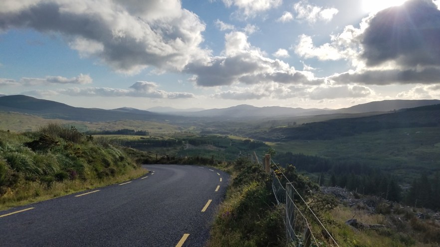
The Conor Pass, which runs from Dingle on the southern end of the peninsula towards Brandon Bay and Castlegregory in the North, in County Kerry, it’s one of the highest mountain pass in Ireland, at an elevation of 410 m (1,345 ft) above the sea level. This narrow road snakes through green vistas, and its views can go on forever, if the weather permits. It drivers the breathtaking, cliff hanging experience of navigating through Ireland’s highest mountain pass, on a narrow and precarious road, weaving its way around the sharp cliff faces as the glaciated landscape of mountains and lakes come into view.
Despite the fact that this narrow and twisting road climbs up the highest mountain pass in Ireland, this road is usually open all year, but during winter months, it can be closed when the access is not cleared of snow. Due to the nature of the road, there are length and weight restrictions, and vehicles such as caravans, camper vans, and trucks can not use the pass. This certainly did not stop them from being up there.
There is a parking lot at the top of the pass to enjoy the views. There is also a short trail that walks up the ridge to the summit of the hill at 482 m (1,581 ft) for even better views as far as the Aran Islands, weather dependent, of course.
For more pictures, check out my album on Facebook.

Connor Pass
The last stop for the day, 144 km (90 mi) from Conor Pass, was the Castleroy Park Hotel in Limerick. Next to the University of Limerick, this 4-star luxury hotel provides bright and spacious rooms with king beds and free Wi-Fi. Guests can enjoy the 50 feet pool, hot tub, and steam room. The hotel is close to Shannon International Airport and the main highways. There is a bus stop located outside the hotel with regular services to the center of the city and Shannon Airport. The Aqua and Leisure Club feature a relaxing sauna, and guests have free access to all of the recreational facilities. The Beauty Salon also offers a relaxing massage or full body scrub. Traditional Irish breakfasts are cooked to order each morning in the award-winning McLaughlin’s Restaurant. Guests can enjoy tea and scones in the conservatory, or a range of beers and homemade Irish cuisine in The Merry Pedlar Bar.
I arrived a bit later in the evening after a long day of driving so decided to give room service a call and just relax in the room before another day of driving and site-seeing. This hotel is definitely nice, but a bit expensive. I was able to get a good deal through Booking.com, thankfully.
For more pictures, check out my album on Facebook.
Limerick to Kylemore
I had planned to start the day at Bunratty Castle & Folk Park, but I got a late start and had to be in Kylemore by 7:00pm, so I decided to skip the Bunratty Castle & Folk Park and, later in the day, Ashford Castle in order to make check-in at the hotel in Kylemore. Stops for the day were Cliffs of Moher and Athenry Castle.
The Cliffs of Moher are the most visited natural attraction in Ireland with around a million visitors each year. With a maximum height of 214 m (702 ft) and stretching a length of 8 km (5 mi), these cliffs are extremely large and steep. This site has not only been used as an ancient fort, but during the Napoleonic Wars, a lookout post and signal tower was built in order to give warning of any approaching French ships.
A stone-built tower can be seen close to the highest point of the cliffs at Knockardakin and visitors could assume that it was built for defensive purposes, but O’Brien’s Tower was built in 1835 by Cornelius O’Brien just to enjoy the views. He believed that attracting visitors to the area would help to relieve some of the local poverty. The tower is still open to the public, but has an extra charge of €2.00 ($2.50) per person to climb to the top. On a clear day, the view includes Galway Bay, the Aran Islands, the Blasket Islands, Loop Head, the Dingle Peninsula, the Twelve Bens (aka Twelve Pins), and Maum Turk Mountains.
Entry to the car park was €6.00 ($7.50) per person. The car park is located across the road from the visitor’s center and there is nowhere else to park in the area, so they get you there. The visitors center has shops, restaurants, and restrooms.
For more pictures, check out my album on Facebook.
Athenry Castle is located about 30 minutes East of Galway, in Athenry. Athenry is one of the most notable medieval walled towns surviving in Ireland, owing its foundation to Meiler de Bermingham who built his castle there 1250. The oldest part of the castle is the hall-keep. It is a large rectangular building originally containing only a hall at first-floor level and dark storerooms at ground level. For extra strength the lower part of the wall slopes out to form what is called a batter. The only original entrance was at first-floor level and would have been reached by an external wooden stairs similar to the present reconstruction. This gave direct access to the hall, the official and ceremonial reception room of the castle.
This castle is fairly small, so it can be toured in 30-45 minutes while having time to look at everything and not feel rushed.
Entry to the site was €5.00 ($6.25) per person and is self-guided. Guided tours are available on request.
For more pictures, check out my album on Facebook.
Athenry Castle
For the night, I was only able to find the Kylemore Pass Hotel with availability. The hotel was quite expensive, but there were no other options in the area. The hotel features a sun terrace and views of the mountains, if the weather cooperates, an on-site restaurant/bar, free WiFi in the common areas, and free private parking is available. The rooms come with a flat-screen TV, certain rooms have a terrace or balcony, and each room includes a private bathroom equipped with a bathtub or shower. Check in is only from 2:30 pm to 7:00 pm. The manager, Stewart, is super friendly and helpful, the room was comfortable and quiet, the food in the restaurant was very good, and my full Irish breakfast the next morning was a great way to start the day.
For more pictures, check out my album on Facebook.
Kylemore to Donegal
I had another long day of driving planned, 345 km (215 mi) and 6.5 hours of narrow, winding roads. Stops for the day included the Kylemore Abbey, Gleniff Horseshoe Drive, Mullaghmore Beach, Donegal Castle, Bunglass Point, and Slieve League before heading to the Bed & Breakfast in Derryhenny.
Kylemore Abbey & Victorian Walled Garden include the restored rooms in the Abbey (Ground Floor Only), the neo-Gothic Church, Mausoleum, the Ironing Stone, trails, and the Walled Garden.
The Abbey itself was built in 1868 by Mitchell Henry and known as Kylemore Castle until 1920 when the Benedictine order of nuns made it their home. The Abbey was home to the Kylemore Abbey Girls’ School until 2010. Although the Benedictine nuns still own and use most of the building, the ground floor is accessible for visitors who can get a glimpse of what life was like in this fascinating building built 150 years ago.
For more than a century, Kylemore has been the romantic nineteenth-century Irish castle overlooking a lake in the West of Ireland. Just a five-minute walk along the shores of Lough Pollacapull lies Kylemore’s enchanting neo-Gothic Church. Kylemore Abbey Neo-Gothic Church was built in the style of a 14th century cathedral. Described as a “Cathedral in Miniature” this beautiful church is a testament to the love of Mitchell Henry for his wife, Margaret.
Hidden in the trees along the avenue is the Mausoleum of Mitchell and Margaret Henry. This simple brick building is a modest resting place with an aura of peace and serenity. When Margaret died on a family holiday to Egypt in 1874, her body was embalmed in preparation for the return journey to Ireland. In time Margaret’s remains were placed in the little mausoleum in the woods where, in 1910, following his death in London, Mitchell Henry was also interred. Although the neo-Gothic Church was completed in 1881, no member of the Henry family was ever placed in it’s vaults.
The Ironing Stone, according to legend, is a magical giant’s wishing stone located on the Eastern avenue. This granite stone was dropped here by two mischievous baby giants playing with their mother’s hot iron. Another version of the tale maintains that the hot iron was being tossed from two nearby mountains by the two great mythical Irish heroes Cuchulainn and Fionn McCool and it was they who dropped it where it now sits today. Turn your back to throw a stone over the top of the stone and your wish will certainly come true.
The Abbey and grounds are definitely worth a visit if only to admire the incredible beauty that the combination of the location and the buildings create. I wish the scaffolding wasn’t on the building while I was there, but what could be seen was magnificent.
Entry to the site was €13.00 ($16.25) per adult and is self-guided. Guided tours of the gardens are available in June, July, and August.
For more pictures, check out my album on Facebook.
The Gleniff Horseshoe is a 9.6 km (6 mi) loop of single lane road through a valley surrounded by spectacular mountain views, breathtaking scenery, and dramatic landscape. As you enter Gleniff Horseshoe you can see the remains of an old mill on the left and driving through you can spot Diarmuid and Grainne’s cave. This cave is said to be the last resting place of legendary Irish figures Diarmuid and Grainne. It doesn’t matter which way you go around the loop, but you may want do it both ways. Some say make sure to travel clockwise around the loop for the best views.
Gleniff Horseshoe is mostly uninhabited now due to famine times and emigration and you can see some ruined cottages and an abandoned school-house beside the road. Make sure to stop several times along the way to make the most of the beautiful scenery and take a few pictures.
There is another valley, just to the West of this one, that has 2 road through it (they do not make a loop). The roads are in bad shape and turn to dirt (mud), but the views are great as well. Even the drive to and from the area is spectacular!
For more pictures, check out my album on Facebook.
Gleniff Horseshoe
Mullaghmore Beach is a long, wide, sandy beach, stretching for about 3 km (2 mi) inside a crescent-shaped bay, backed by a system of sand dunes. From the beach one can enjoy excellent views of the Tievebaun and Truskmore mountains to the rear. While the beach is a paradise for walkers, swimming is popular here too, with the beach protected from the prevailing wind by the headland, and the water depth increasing gradually. Every day between June and September the beach is patrolled by lifeguards. Water sports such as windsurfing, kayaking, and kite boarding are also popular here. The other side of Mullaghmore Head boasts some of the best surfing in the world.
Parking is available at the western end of the beach on the outskirts of the village of Mullaghmore, along the R279, including parking with disabled access, but there are no disabled toilet facilities. Facilities can be found in the small harbour town of Mullaghmore, a popular tourist spot thanks to its views over the sea and of Ben Bulben Mountain. Boat trips out to Inishmurray Island are popular from the harbour.
For more pictures, check out my album on Facebook.
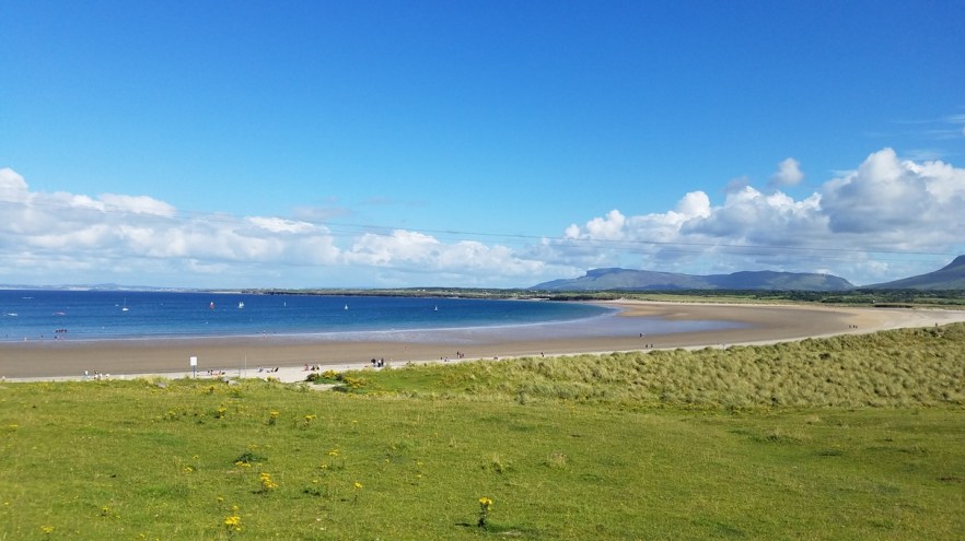
Mullaghmore Beach
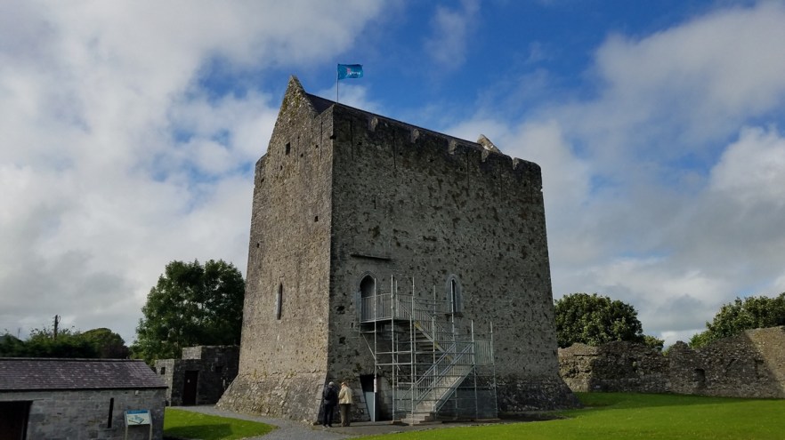
Donegal Castle was the stronghold of the O’Donnell clan, one of the most powerful Gaelic families in Ireland from the 5th to the 16th centuries. Donegal (Dún na Gall) translates as Fort of the Foreigner, possibly coming from a Viking fortress in the area destroyed in 1159. No archaeological evidence of this early fortress has been found. The elder Sir Hugh O’Donnell, wealthy chief of the O’Donnell clan, built Donegal castle in 1474. The castle was regarded as one of the finest Gaelic castles in Ireland.
In 1607, after the Nine Years war, the leaders of the O’Donnell clan left Ireland in the Flight of the Earls. In 1611 the castle and its lands were granted to an English Captain, Basil Brooke. The Brooke family owned the castle for many generations until it fell into a ruinous state in the 18th century. In 1898 the then owner, the Earl of Arran, donated the castle to the Office of Public Works who almost fully restored in the late 1990s.
This castle is quite small, so it can be toured in 30 minutes while having time to look at everything and not feel rushed. The guided tour is actually only 30 minutes long, so self-guided could go faster if you wanted.
Entry to the castle was €5.00 ($6.25) per adult and is self-guided. Guided tours are available every hour and last 30 minutes.
For more pictures, check out my album on Facebook.

Donegal Castle
Bunglass Point: The road begins and ends at the main car park at the foot of the cliff walk. From there it is less than 2 km (1.25 mi) to the cliff-top viewing point at Bunglass, and the same going back. Enter through the large farm gate, making sure you close it behind you to keep the resident sheep from wandering off. The narrow road winds along the cliff top, climbing steadily and taking a hairpin bend or two. There are some steep sections to this walk, but the effort is more than worth it. Some people were able to get the electronic gate open and drove up, but I wasn’t one of those lucky ones. Luckily it was a beautiful day, so the walk wasn’t too bad. Unlike the Cliffs of Moher, there are no safety rails along the cliffs until you get up to the actual point, so watch where you step as the wet ground can be slippery.
Finally you arrive at your cliff-top viewing point. A sheer rocky cliff-face rises dramatically out of the relentless, churning Atlantic ocean far below, interspersed with softer gradients. The Slieve League Cliffs stretch off into the distance in all their rugged glory. Mossy greens, shades of reddish browns, and dark greys contrast against the white foam and deep blue ocean. The serrated cliff-top against the blue sky (if you’re lucky) as sunlight accentuates all the lines on their weathered surface. Two sea stacks emerge from the ocean and because of their unusual shapes, they are locally referred to as “The Giant’s Desk and Chair”.
Keep an eye out for red-billed chough and peregrine falcons. Seagulls circling the sea stacks far below look like tiny dots. You might catch an evening sunset which illuminates the cliff faces with fiery colors, as it disappears over the horizon.
The Kerry Cliffs were beautiful, the Cliffs of Moher were cool, but the Slieve League Cliffs may have won as the most beautiful cliffs I saw in Ireland. Definitely take a trip to this little traveled corner of Ireland
For more pictures, check out my album on Facebook.
The Slieve League (Sliabh Liag) is a mountain on the SW Atlantic coast of County Donegal, Ireland. At 601 metres (1,972 ft), it has some of the highest sea cliffs on the island of Ireland. Although less famous than the Cliffs of Moher, Slieve League’s cliffs are almost three times as high. I decided to view the Slieve League Cliffs from the summit and took the Pilgrim’s Path trail from the landward side up to the peak of the cliffs. Starting from just behind the village of Teelin, the trail took me on a steep track up the mountain, initially a single lane rough track and then ultimately near the top a small rocky and muddy path. It is fairly well-marked and easy to follow until you reach the summit, then the yellow marked stones disappear and you are on your own. It could be easy to get lost up there, so pay attention. At the summit you can walk right to the very edge of the cliffs giving you an amazing view straight down to the sea. Watch your step after hiking through water and mud, the rocks and moss are slippery.
It took me an hour and a half to get up there, but I managed to make it to the summit right before sunset, so was treated to a great sunset and beautiful colors on the cliffs. Knowing that it took me an hour and a half to get up there, right after sunset I decided to head back so I wouldn’t be navigating the steep, rocky, muddy trail in the dark. An hour and 15 minutes later I made it back to the car park with very little light left. There was a couple that just reached the summit when I was heading back and I didn’t see them at all on my way down when I looked back up the valley, so not sure how the hike back was for them, but I can imagine.
DEFINITELY do this hike if you’re able to hike that type of terrain. The views back down the valley are amazing and the view of the cliffs make the views of the valley look plain. Getting to the car park is not the easiest, but worth the trek. There is a gate that you have to open on the road, drive through, and close the gate behind you to keep the sheep on the property, and there are HUNDREDS of sheep along the trail to keep you entertained during the hike. Watch your step with so many sheep (lots of sheep = lots of shit).
For more pictures, check out my album on Facebook.
Leaving Slieve League in the dark was really interesting. The roads being so narrow and winding are tough enough in the day, but the road I took, the R230, through Glengesh Pass in the dark was a different animal all together. I wish I could have seen it during the day, because the steepness and hairpin turns at night made it seem like something incredible to see. Here’s a picture I found online of it during the day on the Lake House Country Hotel website.

After racing 50 km (31 mi), through the dark (1.5 hrs) so I wouldn’t arrive too late for the owners, I arrived at Willow Cottage Donegal B&B in Derryhenny. There are only 3 rooms at this B&B, and all were booked. There are 2 rooms (a single and a twin) that share a bathroom, and an additional double room on the other side of the house, with an en-suite. The property features free WiFi throughout, TV in the room, free private parking on site, and full Irish breakfast (or you can have simpler breakfast choices) prepared by the couple who own the B&B. There is a shared lounge, which is also the breakfast table (8 seats at the long table). Bike rental is available and they can also provide car rental.
I chose the hotel based on it being in the middle of nowhere, with little light pollution. Why? The night I stayed there was the peak night of the Perseid Meteor Shower. Being Ireland, there’s no guarantee you’ll see the sky most days, but that night was nice and clear. Check out my video below!
For more pictures, check out my album on Facebook.
The next day I headed into Northern Ireland, see UK – Northern Ireland – August 2017 for those 2 days.
Back in Ireland, I had only one mission for the day; visit Newgrange. So the night before I from Northern Ireland and stayed at Aaron Vale B&B in Drogheda, 10 minutes from Newgrange. Free WiFi is featured throughout the property and free private parking is available on site. Each room has kettle and tea, a TV with satellite channels, and a private bathroom equipped with a shower, free toiletries, and a hairdryer. There is a shared lounge / breakfast area where included full Irish breakfast was served. The host, Peter, was able to provide some tips for getting to see Newgrange, without having to go to the visitor center and paying to take the shuttle. Unfortunately, the roads were “closed” by construction crews, except the shuttles could go by. I tried every road to New Grange and was turned back at each by a construction crew. I stopped at Dowth before heading to the Brú na Bóinne visitor complex to take the shuttle.
Dowth, the Fairy Mound of Darkness, is about the same size as Newgrange and Knowth and was built in the same period, over 5000 years ago. The mound was subjected to an unprofessional excavation in 1847 and two passage tombs were discovered, but the mound was severely damaged in the process. The passage tombs are much less spectacular than Newgrange or Knowth, with shorter passages and lower roofs. Both are on the western side of the mound and they are referred to as Dowth North and Dowth South.
The Dowth North passage is 14 m (46 ft) in length, is cruciform in shape with a shaft off the right hand recess, and the roof is corbelled and is 3 m (10 ft) high. The Dowth South passage is only 3.5 m (11.5 ft) in length with a simple circular chamber and a single recess to the right. The original roof collapsed long ago and has been replaced by a concrete roof. Dowth South is aligned to the setting sun of the winter solstice and the setting sun illuminates the passage and chamber from about 2:00 pm to 4:00 pm on the days around the winter solstice. There is no public access to the two passage chambers at Dowth.
The Brú na Bóinne area has been a centre of human settlement for at least 6,000 years, but the major structures date to around 5,000 years ago, from the Neolithic period. The site is a complex of Neolithic mounds, chamber tombs, standing stones, henges, and other prehistoric enclosures, some from as early as 35th century BC – 32nd century BC. The site predates the Egyptian pyramids and was built with sophistication and knowledge of science and astronomy, which is most evident in the passage grave of Newgrange.
The site covers 780 ha (1,927 acres) and contains around 40 passage graves, as well as other prehistoric sites and later features. The majority of the monuments are concentrated on the north side of the river. The most well-known sites within Brú na Bóinne are the passage graves of Newgrange, Knowth and Dowth, all known for their collections of megalithic art. Each stands on a ridge within the river bend and two of the tombs, Knowth and Newgrange, appear to contain stones re-used from an earlier monument at the site. Newgrange is the central mound of the Boyne Valley passage grave cemetery, with the circular cairn in which the burial chamber is located having a diameter of over 100 m (328 ft). Knowth and Dowth are of comparable size. There is no evidence for earlier activity at the site, except for the random finding of flint tools left by Mesolithic hunters.
The passage tombs were constructed beginning in around 3,300 BC and work stopped around 2,900 BC. The area continued to be used for habitation and ritual purposes until the early Bronze Age, during which a number of embanked, pit and wooden post circles (collectively referred to as “henges”) were built.
The wait for the shuttle was really long, so I opted to see only Newgrange, rather than both Newgrange and Knowth. I had a 2 hour wait before my shuttle departed, so I spent the 2 hours exploring the exhibition in detail. To wait for Knowth would have been another 4 hours after that. In hind-sight, I wish I would have gone straight to the visitor center and done both, rather than try to get to Newgrange on my own and waste an hour and a half.
Newgrange is the best known Irish passage tomb and dates to 3,200 BC. The large mound is approximately 80 m (262.5 ft) in diameter and is surrounded at its base by a kerb of 97 stones. The most impressive of these stones is the highly decorated Entrance Stone.
The flat-topped cairn is almost 0.5 ha (2.5 acres) in size. It is roughly circular and is estimated to weigh 200,000 metric tons (220,462 US tons). It is made up of rolled stones from the River Boyne. Excavations showed that white quartz stones from quartz veins in Co. Wicklow and round granite boulders from the Mourne and Carlingford areas were used to build the wall above the kerb along the front (South) side of the mound.
The mound covers a single tomb, which consists of a long passage and a cross-shaped chamber. The passage points to the southeast and is just under 19 m (62 ft) long and it leads in to a chamber with three recesses. A corbelled roof covers the chamber. To construct the roof, the builders overlapped layers of large rocks until the roof could be sealed with a capstone, 6 m (20 ft) above the floor. After 5,000 years, the roof at Newgrange is still water proof.
Entry to the center exhibition and Newgrange was €7.00 ($8.75) per person, but there are other options (exhibition only, exhibition and Knowth, or exhibition, Newgrange, and Knowth).
For more pictures, check out my album on Facebook.
After spending the day at Brú na Bóinne and Newgrange, I headed back to Dublin for my flight out the next day. I opted to use some Hilton points for a free night at the Hilton Dublin Airport, which was a nice change from the Bed & Breakfast placed I had been staying in all around Ireland. The hotel is only 5 minutes from the airport and had an underground car park at a rate of €7.50 ($9.40) per day. They also have a free shuttle to the airport that runs regularly. As a Hilton hotel, it has all the standard Hilton amenities such a free WiFi, spacious rooms, comfortable beds, full en-suite bathrooms, etc. I had a very relaxing night at the hotel.
I hope this gives you some inspiration to take a trip to Ireland. For photos from the entire trip, check out all my albums on Facebook and my YouTube channel.
Please share with your friends using the links below. If you have any questions or comments, please reply using the box below.
Thanks for reading!
