
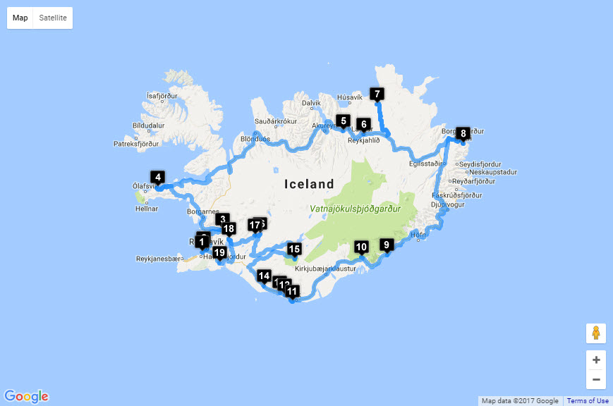
Length: 9 days (6 on the road in a camper van, 3 in Reykjavík)
Tour Company: Over the Horizon (I designed this tour)
Tour: Itinerary-South
Traveler: Dave
Places visited (GPS Coordinates):
1. Kúkú Campers (64.07763,-21.93721)
3. Grand Hótel Reykjavík (64.1429029,-21.8935063)
19. Raufarhólshellir Lava Tube (63.94064,-21.39925)
18. Þingvellir (Thingvellir) National Park (64.26328,-21.11698)
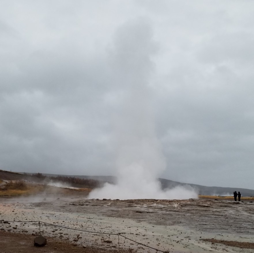
17. Geysir / Strokkur (64.31322,-20.30179)
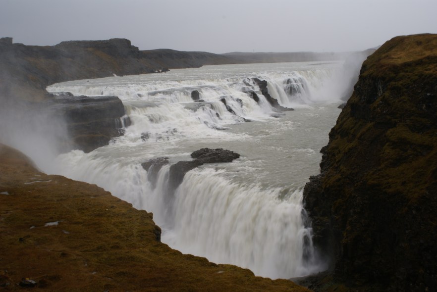
16. Gullfoss (64.32699,-20.12498)
15. Landmannalaugar (63.9830,-19.0670)
14. Seljalandsfoss (63.61549,-20.00756)
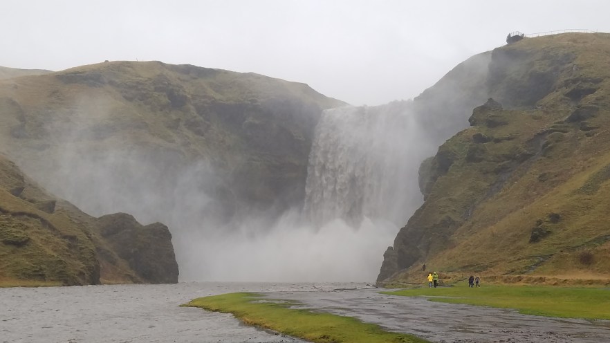
13. Skógafoss (63.52896,-19.51317)
12. Sólheimasandur Plane Wreck (63.49124,-19.36328)
11. Dyrhólaey Arch (63.40221,-19.13290)
10. Vatnajökulsþjóðgarður (Vatnajökull National Park) (64.01503,-16.97373) / Svartifoss (64.02746,-16.97535)
9. Jökulsárlón Glacier Lagoon / Diamond Beach (64.04602,-16.17747)
8. Borgarfjörður Eystri (65.52594,-13.80522)
7. Jökulsárgljúfur / Vatnajökull National Park (66.02833,-16.49788) / Dettifoss (65.81902,-16.37934)
6. Lake Mývatn (65.641615,-16.911850)
5. Góðafoss (65.68429,-17.54888)
4. Kirkjufell Mountain (64.92745,-23.30675)
3. Glymur Waterfall (64.38520,-21.29341)
2. Reykjavík (64.1265,-21.8174)
Silfra (64.25600,-21.11608)
Blue Lagoon (63.88137,-22.45310)
Keflavík International Airport
Upon arrival at Keflavík (KEF) International Airport, immigration is quite easy to navigate and clear. Next stop is the baggage area which has a few options for local SIM Cards.
I used Siminn, which I found has excellent coverage throughout Iceland. It costs $17-18 (October 2016 price) for 30 days, 1 GB of 4G data and can be bought at the 10-11 convenience store just outside baggage claim, to the right. I brought the Siminn APN information with me so I could set it up on my phone with no issues. See below for Siminn APN info for Android and Apple devices, courtesy of Unlockit. Be sure to bring your SIM Card door tool (or a small paperclip) if your phone needs one to get the card out.


After collecting baggage and getting my SIM Card settled, I sat down for a nice breakfast at Joe & The Juice. They have sandwiches and fresh made smoothies. I opted for the Joe’s Club (chicken, avocado, tomato, and pesto panini) and an Iron Man smoothie (strawberry, kiwi, apple). As this was my first meal in Iceland, which I knew was expensive, I was shocked at how expensive ($20).
Interestingly, while sitting in the restaurant at the airport, I was still undecided if I was going to take the North or the South route I had planned. Because of Iceland’s unpredictable weather, I planned the same trip, but based on either route. I literally was on the WiFi at the airport, checking the weather for each location, on the 2 different days I would be there, depending on North or South. You may ask, why is this important? A big part of the trip to Iceland was to see the Northern Lights and to see them, you need clear dark skies. My choices were:
- Go the North route, which was predicted to be cloudy all day, every day, with light rain the first 2 days.
- Go the South route, which was predicted to be heavy rain the first 3 days (thank you hurricane Matthew remnants), but there would be 2 clear nights and 1 clear day on the North side of the island.
After careful discussion with my friend who was joining me, we decided the Northern Lights were something we really wanted to see and the South route was our best chance. Decision made!
At our scheduled pickup time, we were met by a staff member of Kúkú Campers (the camper van rental company), who had a sign with my name on it, and we took their spacious shared van to their main office.
Kúkú Campers
Kúkú Campers is just that, a little Kúkú. Their staff is fun, their smaller vans each have a unique graphic on the side (or can be plain), and they make sure you are set for your trip with a good amount of questions and suggestions. Check out their ad…
Kúkú Campers did have the best deal for the type of vehicle I wanted. I scoured the net for weeks trying to find the best deal for a 4×4 camper van, with a big enough bed, cooking capability, and a separate heater for use while camping. I actually booked my van through a website (Campanda) that searches multiple rental agencies, which was nice because I didn’t have to go through each individual site, but also because they included some items in their rental quotes that were an add-on if booking directly, most importantly, unlimited kilometers. Kúkú offered 200 km per day with their rental, but I did almost 2,000 km in 6 days, and having to pay for the extra kms would have been quite expensive. Kúkú even gave a discount card for Olís, which was definitely appreciated with the price of fuel in Iceland. The card gave a discount on Fuel (3 ISK per liter / $0.04 per gallon) and 10% off in their restaurants.
One important thing to consider (and buy) is insurance for the vehicle. Take ALL the insurances in the max level offered. Driving on the F roads can be dangerous and you will most certainly have paint, and possibly windshield, damage from the rocks kicked up by your tires or from other vehicles.
The van I rented was a Toyota HiAce 4×4 5 speed Manual. This is listed as a 4 person camper, but would only be good for 4 people in the warmer months as 2 people would be sleeping in the pop up tent on the roof. It includes a heating system for the main cabin with a small vent hole leading up to the tent, however, Kúkú does not recommend using the tent in winter, unless you want it to blow off (not covered by insurance). There is a small sink with fresh water tank (full when you leave), butane single burner stove, a cooler (only cools while the power is on the vehicle, so bags of ice should be bought), kitchen utensils, etc. Being 4 wheel drive, this camper allows you to drive all roads in Iceland including F roads, with the exception of F 249. F 249 has at least 3 river crossings that can be deep and require a much more off-road capable vehicle. Driving off-road in Iceland is not legal. All vehicles must stay on marked roads.

Grand Hótel Reykjavík
The Grand Hótel Reykjavík is located in the Northern part of Reykjavík and approximately 1.5km West of the main shopping area of Laugavegur. The hotel offers 3 shuttles a day to downtown Reykjavík, but the walk is not bad. After picking up the camper van, we dropped off luggage we wouldn’t need while camping at the hotel to store in their baggage room until officially checking in 6 days later. This was very helpful and much appreciated.
The room was quite spacious, had a large restroom with separate soaking tub and shower. They even had towel heaters on the wall. The business center was small, but had the necessities of a computer with internet access and a printer. From here I was able to book my bus on Gray Line Iceland from the hotel to the airport. I did not use the conference rooms, restaurant, or lounge in the hotel, but all looked upscale and modern. The staff was very helpful with anything that was needed. The front desk has toiletries in case you forget anything and can help with booking tours if needed. If you find yourself in Reykjavík, the Grand Hótel Reykjavík is a great place to stay.
Time to buy groceries and head out on the adventure!
Raufarhólshellir Lava Tube
The Raufarhólshellir Lava Tube is approximately 1360 m (0.85 mi) long from the entrance to the end of the tube. There are many “skylights” along the tube, but on a cloudy day, it can still be quite dark in the tube. Being underground, it can be quite cool and there is usually a good amount of moisture, especially where it is open to the surface, which means the rocks can be slippery. Be sure to take your time, bring a jacket or fleece, wear sturdy shoes with good tread, bring a flashlight (headlamp would be better), and if you bring a camera, make sure it has a good flash for taking pictures in the dark. I estimated an hour to spend at the tube, but once in the cave, I realized I had underestimated the time it would take to walk through. Give yourself 4 hours or more if you would like to hike the entire length.
There is a dirt parking lot right at the entrance, but when coming from Reykjavík, the sign is just after the lot. If you miss the turn, the highway is elevated, so it is not easy to turn around in a camper (I know from experience).
While driving, you will notice signs on the side of the road that have the symbol below. This symbol is for attractions and helps you find things you may not have even known about:
Þingvellir (Thingvellir) National Park
Þingvellir National Park is located in a fissure zone running through Iceland. This zone exists because Iceland is situated on the tectonic plate boundaries between the North American plate and the Eurasian plate. These plates are splitting apart, so Iceland is growing around 1 inch (2.54 cm) per year. Iceland is the one of only 9 islands that are a visible part of the Mid-Atlantic ridge.
There are multiple parking areas, hiking trails, and plenty of interesting views. You can be hiking through a fissure one minute and looking out over a vast flat plain with the largest natural lake in Iceland. This lake also happens to include the only place in the world where you can scuba dive between tectonic plates, Silfra, but more on that later.
I planned for approximately 5 hours of hiking / visiting the area. Because of the weather, this was more than enough time outside for us. Like anything else in Iceland, though, you could easily spend much more time at any of the locations visited.

Geysir / Strokkur
Our first night camping was here at Camping Geysir. The camp site is located right next to Strokkur Geysir and across the street from the main center, which also has fuel. Before parking for the night, I filled the fuel and was quickly introduced to some of the highest fuel prices in the world, 194 Króna (ISK) per liter or around $7.50 per gallon. To camp at this site, there was a fee for the night. Campgrounds in Iceland tend to close in the winter, but they leave the sites open for campers, free of charge. None of the sites we stay at were closed for the winter yet.
A side note about gas pumps in Iceland is that they require a credit card with a chip AND a 4 digit PIN to turn on the pump. In the U.S. our cards are chip and signature, not chip and PIN like in Europe. There are a few companies in the U.S. that offer a Chip and PIN card, but not many. You can use your debit card, but it must have a PIN that is 4 digits. I personally use Capital One as they have an option for Chip and PIN, which I had to request via phone. It’s the PIN for a cash advance, but is based on the merchant processing code of cash advance or regular transaction. Another advantage to Capital One is they have NO foreign transaction fees. My American Express card also has no foreign transaction fees and a cash advance PIN, but AMEX is not always accepted outside the U.S.
The Geysir / Strokkur area is a geothermal area with multiple geysers and mud pools. All geysers are named as such because of Geysir. Unfortunately, Geysir has been inactive since the early 1980s, but luckily Strokkur erupts about every 5-8 minutes to a height of around 30 m (98 ft). The site is not that big and can easily be completed in less than an hour. I planned for 1 hour to explore and used it by hiking up the large hill behind the area to get a better view.
Gullfoss
For reference, anything that ends in “foss” is a waterfall and Iceland has 1 or 2 (million) of those. On this trip, we specifically went to see 9 of them and saw hundreds, maybe thousands, more.
Gullfoss “Gold Falls” is one of the top 10 waterfalls to see in Iceland. Some lists even have it as the top one to see. One of the more unique features of these falls is that the upper and lower falls are at a 90º angle to each other and the river leading away is in the same direction as the upper falls.
There are 2 main parking areas for the falls. One is located at the top of the cliff and has stairs to get down to the falls and the other is located down at the falls level. Be careful on the stairs as they are very slippery when they are wet. They have metal lips on them, to help melt ice when the sun hits it, but these are slick when wet. The mist from the falls is enough to wet these, if the wind is blowing towards the stairs.
Other than the falls, there isn’t much else here, so an hour is plenty of time to spend in the area before heading off to the next wonderful place.
Landmannalaugar
Landmannalaugar is a geothermal area known for its hiking, hot spring pools, and colorful scenery. The hills here have multi-colored rock, similar to Rainbow Mountain in Peru and the Rainbow Mountains of China. There are several hiking trails here that can take 1 hour or as long as 4-5 days. If you plan on staying here for multiple days, bring enough food to last the whole time, especially in the off-season, as there is nowhere to buy supplies. The store may have some food during the tourist season, but it’s always best to be prepared.
I planned 4 hours for exploring, but the drive took longer than expected and the weather was not good. If planning to visit the area, I suggest arriving the night before, camping here, spending the whole day exploring and move on at a time that puts you back on the main road by dark. If you won’t be able to get to the main road by dark, consider camping another night and move on at first light.
The drive is quite bumpy, even in an off-road vehicle. If you’re familiar with off-road driving, it is pretty fun, but if not, you may not feel comfortable with parts of the trip. We traveled through varying landscapes such as mountains, volcanic plains, and odd spiked lava remnants. I bet it would be amazing to see when it’s sunny outside.
Although I didn’t need it, I decided it would be better to fill the fuel BEFORE going out to the middle of nowhere, just in case. There was a Olís station at the Hrauneyjar Guesthouse on F26 approximately 7 km before the turn-off to F208. I also filled up here after coming back since we had the discount card.
Seljalandsfoss
Our second night camping was here at Hamragarðar. The camp site is located about 500 m past Seljalandsfoss when coming from the main road (2 km off the main road). To camp at this site, there was a fee for the night of 1,300 ISK ($11.50) per person. The site had a kitchen area, restrooms, and washers/dryers for use (some have a fee) in the lower lot house and the upper lot has restrooms (free) and showers (fee). There are also electrical hookups and waste disposal areas for campers that require those amenities.
Seljalandsfoss is the name of the main falls along this area of the cliff, but there are a few more falls along a path to the left for about 450 m (1,500 ft), ending at Gljúfrabúi, located behind the camp site. It is one of the lighter volume falls I have planned on this trip, but it’s the only one that has a path behind it, which was great, but very wet. The wind was blowing straight into the cliff so both the rain and the mist from the falls were getting us along the path. Bring some rain gear if it’s cold and windy. In the summer, it may not be so bad, but it was freezing (literally) when I was back there.
At the end of the path, Gljúfrabúi is has created a hole that it falls into, with a narrow crack through which it can be viewed. There is a path down to the stream where you can get a good view of the complete falls.
I planned 2 hours for hiking around, seeing the falls, and taking pictures, which was more than enough time.
Skógafoss
A quick 30 km (30 minutes) away from Seljalandsfoss is Skógafoss, which is another one of Iceland’s top 10 waterfalls to see. Skógafoss is a 60 m (200 ft) high, 25 m (80 ft) wide, high volume waterfall that is quite the sight. Walking along the river, you can get to the outer edge of the main cut made by the falls. To the right of the falls is a staircase that takes you to an observation platform at the top of the falls. This platform provides not only great views of the falls and the river feeding the falls, but also the surrounding landscape.
If you are into hiking and have the time, at the top of the falls is the beginning of a trail that runs along the Skógá river and you can see many more waterfalls. I only planned an hour here to see Skógafoss, which was adequate for the hike to the top and back, but if interested in hiking further upriver, or even to a smaller river on the other side of the small village, plan to spend a full day in the area. There is a camp site right next to the parking lot should you want to spend the night. The ground can be very wet (looks more like a lake) when there are heavy rains, so you may not be able to park campers on the grass or set up a tent. Check at the small building at the beginning of the parking lot for details.
Sólheimasandur Plane Wreck
On 21 November 1973, a U.S. Navy R4D-8 (Super DC-3) crashed on the Sólheimasandur beach. The story of how it crashed is that it ran out of fuel after the pilots switched fuel tanks to an empty one without realizing it. The aircraft actually crashed closer to the ocean, but was moved uphill for salvage operations. After some research, it appears the salvage was stopped after a helicopter being used also crashed and the aircraft has been in the same spot ever since. I’ve also seen that it crashed due to heavy icing, but have not been able to find an actual accident report to confirm.
Prior to March, 2016, the wreck was accessible by vehicle through a gate at the main highway. There is a marked path to follow from the gate to the aircraft. Due to tourists lack of respect for the road and taking their vehicles anywhere they wanted, the landowners have since locked the gate and the only way to the aircraft is to park near the gate and make the 4 km (2.5 mi) walk to the aircraft and then walk the same 4km back. Thankfully the path is well marked with reflector posts on both sides, otherwise it’d be easy to lose your way in the seemingly endless plain of volcanic sand. While every picture of the aircraft I have seen shows black sand, apparently the sand is actually a dark greenish, sometimes reddish grey, and turns pure black when it gets wet. I imagine it’s nearly always black because honestly, how often is South Iceland actually completely dry?
Due to the lengthy walk, plan on spending 3 hours at this site. This allows for 1 hour walk each way and an hour to spend at the wreck. I’ve seen some amazing pictures of the wreck with the northern lights over it, which I was really hoping to see, but it was cloudy, windy, and rainy while I was out there, so no chance of seeing that. If you get the chance to see it at night, I’d love to see pictures of it with the stars or northern lights.

Dyrhólaey Arch
Head down the road from Sólheimasandur for about 16.5 km (20 minutes) and you’ll find yourself on top of a 270º cliff with a lighthouse. From here you can see the black sand of Sólheimasandur beach to the West, the Atlantic Ocean to the South, and the fantastic cliffs to the East. Most notably is Dyrhólaey Arch, a 120 m (400 ft) high, thin cliff, that protrudes out to the water and has 3 holes through it, large, medium, and small. The largest of the 3 is the one referred to as the Dyrhólaey Arch.
The main reason for coming to Dyrhólaey Arch was to see the puffins that nest on the cliffs. Unfortunately, puffins begin to migrate near the end of September, so there were none left when I was there. I scheduled 2 hours for exploring, but since there were no puffins in the area and the wind was getting stronger, we didn’t need as much time.
Vatnajökulsþjóðgarður (Vatnajökull National Park) / Svartifoss
The next stop was 160 km (2 hours) away at Vatnajökulsþjóðgarður (Vatnajökull National Park) where we camped for the night. There is a campground near the main building, but since it had been raining so much from the hurricane, the camp site was flooded and we parked in the main lot for the night. The main lot is not normally open for camping, but because of the conditions, everyone was parked in the lot. We did not have to pay for camping here as the office was closed as of September 30th. The restrooms were open and the building had a fresh water spout on the outside for filling water bottles, which was nice that we didn’t have to buy any from the store. The fresh water rivers in Iceland are very clean and you can drink the water from them without needing to boil it, which I did.
While having dinner, we could see the moon peeking through the clouds. This is the first time since we’ve been in the country that we can see something above the clouds. So, I set up my GoPro to take Night Lapse pictures and hopefully catch the Northern Lights. We sat outside for a little while and it started to rain a little and we figured the night would be a washout again. We went to sleep, but I left the camera on for the night. When I got to the hotel a few days later, this is what the camera caught…
I planned 2.5 hours in the morning (THE SUN IS OUT!!) for hiking to Svartifoss and we needed every bit of that time. The hike itself is pretty easy even though the main trail was closed and we had to take another, less used trail. It was the scenery that made it take so long. The scenery is amazing and distracting, so we were always stopping to take pictures and look around. There is a large glacier to the left of the trail (Skeiðarárjökull) and 2 visible smaller glaciers to the right of the trail / visitors center (Skaftafellsjökull is closest and Svínafellsjökull is farthest). You can also see Hvannadalshnjúkur, Iceland’s highest mountain, from here.
When driving away from here to the next stop, the North side of the road is all part of the national park and is full of volcanoes and glaciers, making it very hard to drive. Being the passenger in Iceland is definitely a bonus!
Jökulsárlón Glacier Lagoon / Diamond Beach
Jökulsárlón Glacier Lagoon is am 18 sq. km (6.9 sq. mi) lake that is up to 248 m (815 ft) deep and is now Iceland’s deepest lake. Global warming has increased the recession of the glacier, making the lake bigger every year. There are tours that run Amphibious Vehicles around the icebergs for an up close look. Seals can also be spotted swimming in the lagoon and lounging on the icebergs and rocks. The ice falls off into the lagoon, floats around, and eventually makes its way out a narrow channel that passes under a bridge for the main highway and out to the Atlantic Ocean. Once the ice reaches the ocean it gets washed back up on the black sand beach by the waves, which makes the clear ice look like diamonds in the sand.
Diamond Beach is really beautiful and I’m glad the sun was out to really show off the contrast between the clear/white/blue ice and the black sand. There were quite a lot of people on the beach, many with some pretty high-end camera equipment and even drones. I was out there with my Samsung Galaxy S7 mobile phone taking perfectly fine pictures for me and spending more time enjoying what I was seeing.
Borgarfjörður Eystri
The next stop on the trip was Borgargjörður Eystri, a very small town located in the fjords of the North East coast with a large puffin colony. The drive was 4.5 hours from Diamond Beach and the cliffs, fjords, and other scenery along the way made for a very nice ride. As the day grew darker, we realized we weren’t going to make it before sunset and would most likely not be able to see the puffins. Taking into consideration that Borgargjcörður Eystri is an hour off the main highway, it was already dark when we got to the turn, and since there were no puffins on the Southern coast, there were probable no puffins here either, we decided to skip this destination and continue on to Jökulsárgljúfur / Vatnajökull National Park (another 2 hours).
Jökulsárgljúfur / Vatnajökull National Park / Dettifoss
The night sky was crystal clear and we saw many meteors, but no Northern Lights, on the way to Jökulsárgljúfur / Vatnajökull National Park. Upon arrival, we pulled up to the main building at the Ásbyrgi camp site, which is open from May 15 – September 30, but as with most camping in Iceland, the restrooms and showers are still open. The restroom was spacious, clean, and the temperature was very warm (appreciated). It was great to have a nice hot shower for 500 ISK ($4.50) for 5 minutes. The building also had a washing machine for a 500 ISK charge and a drying closet.
We drove through the whole camp site and saw no other vehicles. We backed in to a nice open spot with a good view of the sky and I again set up the GoPro to take Night Lapse pictures. Here’s what it caught:
The next morning, we woke up to clear skies and freezing temperatures and couldn’t wait to start a busy day of exploring. We packed up the van and headed for the main building to use the facilities. We were greeted by the Park Rangers who asked if we camped the night before and if we had paid. We had not, because nothing was open when we arrived and the visitor center has not opened yet for the day. The ranger was more than happy to process our payment on his mobile register. Cost for the night was 1,600 ISK ($14.15) per person.
After paying the ranger, we were finally off to our first stop of the day, Dettifoss. I’ve planned for 3.5 hours of exploring, as the route takes us in the direction we were heading anyway. Along the road we saw one of those attraction symbols for something called Hafragilsfoss (65.83971,-16.39504 entrance to the lot, 65.83217,-16.40047 falls), so we pulled in to check it out. There were some beautiful views from high up of the canyon, a waterfall (Hafragilsfoss), and the surrounding area. It was a nice, unexpected surprise.
We got back on the road and the next attraction was Dettifoss (65.82460,-16.37288 entrance to the lot, 65.81439,-16.38455 falls). From the parking lot, you hike down the trail to an observation area, and then closer to the falls. The falls are 44 m (144 ft) high and 100 m (330 ft) wide and is the most powerful waterfall in Iceland in volume. It was pretty impressive even with the water being low on this side of the country. You can get right next to the falls, but be careful on the wet and possibly icy rocks.
From Dettifoss, it’s a 1.4 km (0.9 mi) hike up river, over rocky terrain, to reach the next falls, Selfoss (65.80585,-16.38748). Selfoss is a set of curtain falls that spill over a V-shaped cut in the canyon floor. Since the water was low, we couldn’t see the falls in all their glory, but it was still impressive. In low water time, the water cascades over the West side, which was good as I was on the East side and could see it. In flood times, the water can cover the whole area and will cascade over both sides and sounds amazing.
I highly recommend spending some time exploring all these falls. The whole area is so different from the Southern half of the island. This area is a more dry and desert environment with a lot of dirt and little vegetation.
Lake Mývatn
The Lake Mývatn area is full of geothermal features such as mud pools, hot springs, volcano craters, and a large number of rootless cones (pseudocraters) which were caused by steam and not an actual magma eruption. Coming from the East, as you come down the big hill towards the lake, there is a parking area where you can park and look at the whole area. I planned for 4 hours in the area to check out as much as possible before heading off to the next stop for the day.
Once down by the lake, I turned south on 848 and headed for the first stop, Hverfjall Volcano crater (65.61068,-16.91733 entrance to the lot, 65.60447,-16.87434 volcano). The volcano erupted approximately 2,500 years ago and left an almost perfect conical crater of volcanic ash. The hike up from the NW parking area starts off at a reasonable angle and the second half is much steeper. Going up isn’t so bad, but coming down is a little tough due to the loose ground and trying to hold yourself back. Once making it to the top, the view of the crater and the whole Lake Mývatn area, are amazing. The crater is much bigger than you think when you get to the parking lot. It is about 1 km in diameter and you can walk around the whole rim.
Continuing South along 848 there was an area to pull off on the side of the road and take a look at lava pillars and the clear water of the lake. The road then turns to the West, traveling along the South side of the lake. Here I got my first look at the pseudocraters, which is actually a sheep grazing area called Skútustaðagígar. There are parking areas at both entrances and walking paths through the area. It’s free to enter and they only ask that you stay on the paths, don’t bother the sheep, and be sure to lock the gates as you go through. These pseudocraters look like mini volcanoes covered in grass and are really interesting to walk on and around.
There are hundreds more pseudocraters in the area where 848 meets back up with 1 on the SW side of the lake, but it was time to get back on 1 West and head for the last stop before sunset.
Góðafoss
38 km (30 minutes) from Skútustaðagígar is Góðafoss “Waterfall of the gods”, a 12 m (40 ft) high, 30 m (100 ft) wide set of falls with a set of large rocks in the center that split the falls into 2 main falls. Góðafoss (65.68684,-17.54522 entrance to the lot, 65.68271,-17.55023 falls) is considered one of the most beautiful waterfalls in Iceland. According to the locals, it is the Beauty to nearby Dettifoss, the Beast. As with most of the falls in Iceland, you can walk right up to them by making your way across the rocks.
I planned for 1 hour at the falls and was plenty of time to explore the area and take pictures. There is a fuel station, café, and restroom across the bridge from the Góðafoss parking lot. This was an excellent place to fill up before departing for a 439 km (266.5 mi), 5.5 hour ride across Northern Iceland in the dark. We’ll have more than enough fuel to make the journey and no worries of trying to find fuel along the way.

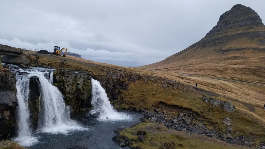
Kirkjufell Mountain
We arrived at nearly midnight to the small town of Grundarfjörður, located in the far West of the island. First stop in town was for fuel so we wouldn’t have to do it in the morning and waste any daylight. After getting fuel, we headed over to the campground (64.92125,-23.25967), which was easy to find as there are signs on the roads and the GPS knew where it was too. The campground was closed, including all the restrooms. After a 5.5 hour ride, that wasn’t what we were hoping to find at the only campground in the area. We parked the van in the lower lot, where there were only 1 other camper van and another person in a tent and went right to sleep.
In the morning, we woke up to cloudy skies again, but it wasn’t raining, so no problem. The only stop in this area was Kirkjufell Mountain and Kirkjufellsfoss, which was only 5 minutes away from the campground. Kirkjufell is a single mountain on its own peninsula and Kirkjufellsfoss is the waterfall across the street. The view from the falls offers a great picture of the falls and mountain together and is the most photographed mountain in Iceland.
I planned for 1.5 hours here, which was far more than needed to walk the falls trail and take pictures. There is a trail around and up the mountain as well, but a guide is recommended and it’s quite tough as it’s very steep.
Glymur Waterfall
The final stop on stop on the camping portion of this trip is Glymur Waterfall. Glymur is a 198 m (650 ft) tall horsetail fall and is Iceland’s tallest waterfall. It falls into a deep canyon that the locals say is what really makes the hike worth the trip. The hike takes about 4 hours round trip, but I only planned on 2.5 hours based on the trail length, not taking into account the difficulty. So, if you get to Glymur, plan on at least 4 hours.
Unfortunately for us, due to all the heavy rain the log over the river was completely under water and could not be crossed. We did get to watch some Canadians five it a try, but once the icy water got above the boots, they thought otherwise. The views on the trail up to this point were spectacular, but I really hoped to see the falls. There is another trail, twice as long and steep, that goes over a mountain and comes around from above the falls, but that takes a whole day and was not possible. There is a trail that goes up the West side of the river to the falls, which we did not know as the trail for Glymur points to the Eastern trail. From the Western trail, you can see the canyon, but the falls come over that side of the canyon and is best viewed from the Eastern side.

Glymur – Photo from Extreme Iceland
Since we had some extra time due to a shortened hike, we decided to relax and have some brunch and pack up the van some before heading back to Reykjavík and returning the van.
Reykjavík
The city of Reykjavík is one of the smallest capital cities in the world and is also the northern most capital city of a sovereign state at 64.13333º N. Of the 330,000 residents of Iceland, around 130,000 live in the city and another 70,000 live in the capital area. That means that the same amount of people as those living in the city call the rest of the country, outside of the capital area, home. In the U.S. that would be the same as 159.5 million people living in Washington D.C. and the other 159.5 million residents living in the rest of the country, outside the D.C. area.
I only spent a few hours walking around and seeing the sights. From the hotel, I walked about 100 m South to the main shopping street of Laugavegur and turned East for 1.5 km to head to the part of the city where the restaurants, stores, Hallgrímskirkja cathedral, and the Sólfarið (Sun Voyager) sculpture are located. There are also some small museums/galleries (Icelandic Phallological Museum of Penises, ART67 gallerí, different tattoo shops/museums, etc.) located along or just off this main road. It is common in Iceland for stores to open after 9am, usually more like 10 or 11 am, so don’t expect to get an early start to shopping.
Hallgrímskirkja cathedral is open to visitors daily from 9 am – 5 pm in the winter / 9 am – 9 pm in the summer, with the exception of during services. The cathedral can be toured free of charge, but if you want to go up in the 73 m (240 ft) tall tower, which offers amazing views of the city, there is a charge of 900 ISK ($8.00). There is a small elevator that takes you almost to the top, and 1 flight of stairs to the upper observation area.
From the cathedral, we walked back down the hill on Frakkastigur all the way to the coast. To the left is the Sólfarið (Sun Voyager) sculpture, a large (17 m / 56 ft), steel, Viking-looking ship perched on its own platform by the harbor. It was built in 1986 for a contest celebrating the 200th anniversary of Reykjavík and won. The platform was built and the sculpture was placed here in 1990. While there, quite a few people came to sit and look out over the harbor, take pictures, and the news even used it as a background for a story.
Reykjavík is a quirky little city full of interesting places to see, things to do, and people to watch and converse with.
Silfra
I’ve wanted to do this dive since I first heard about it. It is a once in a lifetime dive. Once in a lifetime because it’s WAY too cold to do again! Silfra is located in Þingvellir National Park and is considered one of the best dive sites on Earth. because of its incredible visibility of over 100 m (330 ft) and multi-colored algae adds to the wow-factor. The water comes from Langjökull glacier and undergoes an underground, 50 km long, lava rock filtration process that can take up to 100 years for the water to arrive at the underground wells of lake Þingvallavatn. This unique process means that the crystal clear water in Silfra fissure offers some of the best diving visibility in the world and yes, you can drink it straight from the lake with no worries.
Silfra fissure is composed of 4 main sections, Silfra Lagoon, Silfra Deep Crack, Silfra Cathedral and Silfra Hall, which all have their own features. Silfra can reach a depth of 63 m (207 ft) and is just over 1 m (3.3 ft) wide where it is the most narrow. Divers enter the water from a platform and can expect to dive at a depth of up to 18 m (60 ft), the max depth allowed by the park. Because this water comes from a glacier, and we are in Iceland, the water usually maintains a temperature between 2° – 4° C (35.6° – 39.2° F). I was pleased to hear that it was not 2° the day I went, but was a balmy 3° C (37.4° F).
The fissure itself is located at the meeting point between the North American and Eurasian continental plate and as such is the only diving ground where you can dive or snorkel between two shifting tectonic plates. SPOILER ALERT! A common misconception is that you can literally touch the 2 plates in this fissure and there are thousands of pictures out there of people touching the 2 walls of the fissure. This is not quite true. Yes, this is the only place where you can snorkel or dive “between two tectonic plates”, but the plate boundaries are actually around 7 km apart and the national park is located in the volcanic valley left in the middle. So, unless you have really long arms, you can’t technically touch both plates at the same time.
I booked my dive online with Dive Silfra well ahead of time. The tours are limited to 4-5 people per time slot,and 2 time slots per day. They do sell out, especially in the summer months. This tour is only available if you have a PADI (or equivalent) open water certificate, which you must show them before you can dive, and you should have over 20 dives and feel comfortable diving. On the reservation form, they ask you if you are a certified diver, do you have any experience with a dry suit, and what are your measurements for the dive equipment. This trip is quite expensive, so be absolutely sure you want to and are able to do it before you book. One girl booked it and did not have an open water license, she had taken a SCUBA class at a resort once and thought that counted. The guides would not let her do the dive but allowed her to join the snorkelers. This dive is taken seriously by all.
I was picked up at my hotel by their shuttle van at 9 am and taken to Silfra. Once we arrived, the guides started to get out our crazy amount of gear while we went to the dive briefing. After the briefing we got to start putting all our gear on. I got to wear my own clothes which was 2 pairs of wool socks, Under Armour Cold Gear thermal pants and shirt, Ice Wear (Icelandic company) fleece pants, a tee-shirt, and I had a fleece sweatshirt as well. The gear they added was fleece overalls with feet, fleece top (so I removed mine), a super tight hood that comes down over the shoulders, the dry suit (which was a real treat to get on over all those layers), the BCD with all the dive gear on it, 24 kg (53 lbs) of weights, lobster claw cloves, fins, and a mask. To top it all off, they have a lovely choker to keep water from leaking from the face hole in the hood, down your neck into your suit. They actually say that it should be tight enough that you feel like it’s hard to breathe (“like a kid is choking you”), but you can still breathe. That’s what we need while 18 m under water, for breathing to be hard. But hey, with 3° C water, I’ll go with it, even if I was a little light-headed. With the near 45 kg (100 lbs) of gear on now, we walked 100 m (330 ft) from the parking lot to the entry to the fissure. All this gear is pretty hot, so getting in that cold water is welcomed. When it’s our turn to enter, we walk down the stairs to the platform, put on the fins and mask and step off into the water. With a dry suit on, you float really, really well. We checked our buoyancy for proper weighting and began the 45 minute dive. The cold wasn’t as bad as I expected. The face is cold for a few minutes at first, but quickly you lose feeling and it’s not an issue. When you get down deeper, the dry suit compresses and touches your clothes. Without that thermal boundary of air, the cold comes right through and you can really feel it. Luckily it only lasts a few minutes before you start to ascend and the suit opens up again. Once the dive was complete, we exited on a platform and had a 500 m (1,650 ft) walk back to the lot, with all our gear. Thanks for the workout!
Although it was truly amazing, it is not an easy dive and unlike any regular SCUBA dive, mainly because of the dry suit. Your buoyancy is completely thrown off, you can’t operate the BCD the same as you normally would. You can’t put your feet horizontal to your body or above your head (like to dive down) or all the air in the dry suit will go to your feet and you will be floating upside down with your feet out of the water. Yes, they warned us and yes, I was the one upside down with my feet out of the water. Thanks to one of the guides who helped me right myself and continue on my way.
Check out my GoPro video below:
Blue Lagoon
The famous Blue Lagoon in Iceland. Everyone who’s looked at any travel site regarding Iceland has seen the Blue Lagoon. Every airline that comes to Iceland has a trip to the Blue Lagoon that takes you directly from the airport to the lagoon before heading to the Reykjavík hotels. It’s their “Welcome to Iceland” tour. It is the single largest tourist attraction in Iceland.
The Blue Lagoon is about an hour South of Reykjavík and consists of a spa, restaurant, hotel, and the very large thermal pool that stays around 39º C (102º F). It’s called the Blue Lagoon because the water has a cloudy blue color to it from the silica and how light reflects off the silica. The water is actually white, but it appears blue when the light hits it. The lagoon was formed in 1976 during operation at the nearby geothermal power plant. People began to bathe in the unique water and apply the silica mud to their skin.
I got to spend about an hour and half in the water, which is about 0.8 – 1.2 m (2.5 – 4 ft) deep through most of it. There is a Silica Bar in the lagoon that has the masks that you can put on. I applied the silica mask and kept it on for about 10 minutes before rinsing it off in the lagoon. I’m not sure if it made my skin feel any better, but it was interesting.
After the lagoon and a nice hot shower in the locker room, we got to have dinner in their restaurant Lava Restaurant, where I had an amazing grilled beef tenderloin with wild mushrooms, crispy potatoes, onion jam, and dijon mustard. We were here as part of a conference my friend was attending, otherwise I wouldn’t have eaten here. The tenderloin is 5,900 ISK ($52.00) and drinks were quite pricey as well.
If you’re looking to have a spoiled spa day though, this is your place. Packages start at €40 ($42) in the off-season and €50 ($52) in the high season for the basic package, which includes entrance to the lagoon and silica mask in the lagoon, to €195 ($205) for the Luxury package which includes entrance to the lagoon, silica mask in the lagoon, use of a towel, 1st drink of your choice, algae mask, use of a bathrobe, slippers, reservation at Lava Restaurant (food not included), sparkling wine at dinner if dining at Lava, Spa Journey Product Set, and entrance to the Exclusive Lounge.

Blue Lagoon – Photo from Blue Lagoon Iceland
The next morning, my time in Iceland has come to an end. I booked a bus from the hotel to the airport with Gray Line Iceland. The ride included a transfer at their main terminal. I was able to choose my pickup time and pay for my ticket directly on the site. The ticket was €24, which was much more affordable than a cab, which can run around €80-€100 between Reykjavík and the airport. The transfer from the shuttle bus to the main bus was quick and easy. The driver moved the baggage from the van to the main bus while I went inside to get my ticket for the main bus. I showed my online confirmation to the cashier and she printed my ticket for the bus. The entire trip was 1 hour and 15 minutes from pickup to drop off. It is around 15 minutes from the hotel to the terminal, 15 minutes before departure, and 45 minutes from the terminal to the airport. The bus is very punctual, so be sure to plan accordingly.
I hope this gives you some inspiration to take a trip to Iceland. You won’t regret it. For photos from the trip, check out my album on Facebook.
Please share with your friends using the links below. If you have any questions or comments, please reply using the box below.
Thanks for reading!
