

Length: 14 days
Tour Company: G Adventures
Tour: Quest for the Antarctic Circle
Traveler: Dave
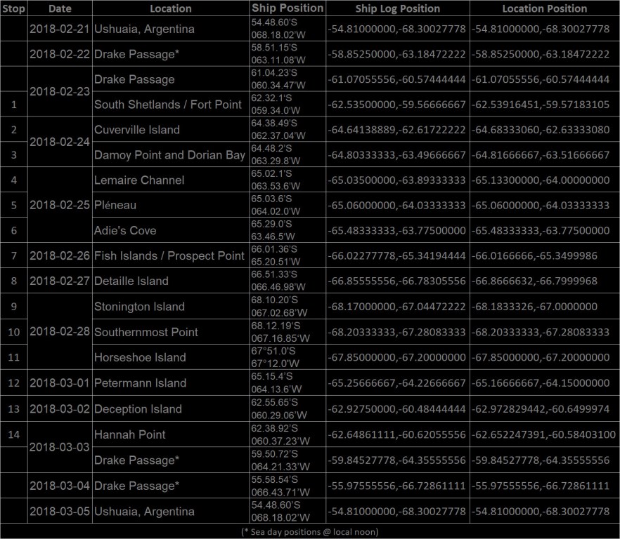
As you can see on the map above, me made quite a few stops and went far below the Antarctic Circle. Below is the list of stops and positions along the trip with the corresponding Stop # for the map above.
How does one get to Antarctica? Aside from being a scientist that is stationed in Antarctica, there are only a few ports North of the Drake Passage that you can depart from, but the closest to Antarctica, and therefore the shortest amount of time sailing through the Drake, is Ushuaia, Tierra del Fuego, Argentina.
Flying with Aerolíneas Argentinas, I departed from New York’s JFK Airport and headed 11 hours South to Buenos Aires, Argentina, arriving at Ezeiza International Airport (EZE). From EZE, I needed to get across the city to Aeroparque Internacional Jorge Newbery (AEP) and catch my flight to El Fin Del Mundo (The End of the World), Ushuaia’s International Airport Ushuaia-Malvinas Argentinas (USH).
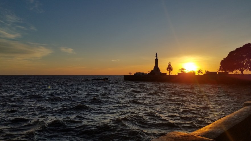
- Sunrise from the Aeroparque Internacional Jorge Newbery, Buenos Aires
Aerolíneas Argentinas did not offer web check-in so I had to do so at JFK. I arrived well before my flight, about 3.5 hours early, and there were no lines yet for the flight, so check-in was quick and easy. Security at Terminal 7 was also quick and easy because of how early I arrived.
Upon arrival in Argentina, Aerolíneas Argentinas had a free shuttle service between Ezeiza International Airport and Aeroparque Internacional Jorge Newbery if you had a same day connecting flight booked on the same ticket. You can print the shuttle passes 48 hours before scheduled departure. Shuttle service was offered on Manuel Tienda León, which offers a comfortable coach that runs between the 2 airports (scheduled for 1 hour and 10 minutes) with a stop at their main office in the city. After gathering baggage, there is a Manuel Tienda León desk at both EZE and AEP, depending on which direction you are going, where you present your pass and they give you a ticket for the bus. Baggage is tagged, stored under the bus, and you must present your bag tag to get it back at the other end, so it is secure. The bus also has free WiFi to keep you entertained on the journey across the city.
All the airport in Argentina would not allow check-in more than 3 hours before the flight, so be prepared to do some sitting around with your baggage if you have a long layover (I had layovers of 11 and 9 hours).
Since I was going on a ship for 2 weeks and would be out of data range, I opted not to get any SIM card for this trip. I did, however, get money from the ATM in Buenos Aires as places in Ushuaia may or may not accept credit/debit card, and their ATMs don’t always have cash because of the number of tourists and possible strikes (which happened one day while I was there) that prevent the ATM from being refilled.
Upon arrival in Ushuaia, I picked up my baggage, exited the airport and waited for my pickup from G Adventures, but it did not arrive. Soon I was the only passenger left at the airport, so I grabbed a cab to my hostel. The cab ride cost 200 Pesos, which is $10.00 US. The symbol for Pesos ($) is the same as US Dollars ($), so it looks like something is very expensive, but the exchange rate was 20 Pesos / 1 Dollar while I was there.
Ushuaia, located on the Northern shores of the Beagle Channel, is the largest city in Tierra del Fuego and is commonly regarded as the Southernmost city in the world. While there are smaller settlements farther South, the only sizable one would be the Chilean Naval base Puerto Williams (approx. 2,500 inhabitants including civilians) on Isla Navarino, across the Beagle Channel ,to the South of Ushuaia. In the past, Ushuaia has been a missionary base, penal colony, and naval base for the Argentine Navy. Today the provincial capital, with its approx. 80,000 inhabitants, is a bustling tourist town, complete with casinos, numerous restaurants, and hotels catering to all budgets and tastes.
The first 2 nights in Ushuaia, I used Booking.com to book my reservations at Hostel Cruz del Sur, which is only 2 blocks from the meeting hotel (Albatros Hotel) for the tour. Hostel Cruz del Sur is located just 1 block up the hill from the main shopping/dining street and 2 blocks up the hill from the main road along the channel. The price includes free WiFi, which is very slow and not always available, bed linen, and an Argentinian breakfast (fresh bread, tea, milk, coffee, jam, and butter) from 08:30 – 10:00. The hostel has a very welcoming, rustic, and a colorful atmosphere. It is filled with maps, photos, flags, and postcards left by travelers from all over the world. In the library room travelers can relax using their computer, reading, or just hanging out with other guests. There are no strict rules and while there is no curfew, quiet hours are from 23:00 – 7:00. A security code (given after check in) is required to enter the building. There’s cable TV in the main common room, a small equipped kitchen free to use from 8:30 – 22:00, there are shared restrooms with toilets and showers with hot water 24 hrs a day. Local Insurances Rules of the town don’t allow them to have plugs in the rooms, but there are plenty scattered throughout the common areas. Everyone else’s devices are plugged in and laying about, so there is no need to worry about your items being taken. The front desk can help organize excursions (pick up from the hostel) and can give you all the information you need about the area.
Check-in is from 13:00 and check out is by 10:00. Credit/Debit cards are not accepted and the room must be paid in advance with cash. Prices are based in US Dollars, but if you wish to pay in Argentine Pesos, you can do so but at the exchange rate of the date in which you arrive, not at the exchange rate of the day you made the booking.
Hostel Cruz del Sur is a great place to stay if you’re in Ushuaia and very affordable. A bed in a 6 person dorm was USD $24.00 per night. There is a grocery store 2-3 minutes walk up the road and Ushuaia is small enough that you can walk across the town in 20 minutes.
Before the tour started, I had 2 days to spend around Ushuaia and was able to visit the Museo Maritimo (Maritime Museum), the Casino Club, and have lunch at the Hard Rock Café (because siesta time at all the local restaurants is when I’m hungry!)
Available in Ushuaia are some passport stamps that you have to know where to find them. Apparently, there used to be 4, but now there seem to be only 2 available. Thanks to a fellow passenger who read about them, we were able to find where to get these stamps. If you’d like to know where to find them, feel free to send me a message using the comment section below, on Facebook, or Instagram.

Museo Maritimo: The museum is located in an old prison and each of the wings holds a different museum. There are the Maritime, Prison, Antarctic, and Marine Art Museums in 4 of the wings and the fifth wing is not currently accessible.
The Maritime Exhibit shows the links between locals and the sea for communication up to the middle of the 20th century, when commercial flights started.
The Prison Exhibit is a permanent exhibit in the first pavilion next to the entrance showing the history of the prison, its building, works by prisoners, and featuring some of the most famous convicts.
The Antarctic Exhibit is a true discovery of the history, explorers, and travelers who made relevant contributions to our knowledge of this region. This exhibit also shows Antarctic biodiversity and draws a comparison with the Arctic as part of the International Polar Year (IPY) program.
The Marine Art Exhibit contains temporary exhibits of local, domestic, and foreign artists throughout the year.
Entry to the museum is 400 pesos ($20.00) per person and the ticket is valid for 48 hours, giving you plenty of time to see everything.
Casino Club Ushuaia: The End of the World Casino is built on 3 levels. On the ground floor you can enjoy a bar/lounge (which serves food) and a wide range of slot machines. On a raised level, overlooking the Canal, is the Entre Fuegos Restaurant and a stage where local, national, and international artists are featured. The stage location allows you to enjoy the shows from anywhere in the Casino. Behind the bar, on a raised level are the table games, which are only open in the evening through early morning. On the upper floor is a second slot machine area and a second bar/lounge.
This casino has one slot machine that payed out pretty well. This was only machine that was not repeated anywhere in the casino and was a nickel ($0.05 Pesos or USD $0.0025) slot with minimum bet of 25 credits ($1.25 Pesos or USD $0.0625) per spin. If you go, try to find it!
Hard Rock Café: Like most Hard Rock Cafés around the world, the venue is a bar, restaurant, music venue, and a store. Hard Rock Café Ushuaia has three levels of indoor dining space that can accommodate up to 300 guests. This café was custom-built for entertainment, with a large special event hall, two bars, and four professional bowling lanes. In the Rock Shop you can pick up something to commemorate your trip.
The service was quite slow and the bread for the burgers and sandwiches was quite dry and crumbled when you tried to eat it. I ended up using a fork and knife to eat all the meals I had there. As with all Hard Rock Cafés, the prices for food and drinks are higher than most places.
For great local beer, try Cerveza Beagle, which is brewed in Ushuaia. They have a blonde (golden ale), red (red ale) , and black (cream stout). I enjoyed the black very much and I was told the others are quite good as well.
Day 1 – Arrival Day
Today began with heading to the meeting hotel to check in, or so I thought. While my paperwork says I was supposed to stay at Albatros Hotel, when I went to check in, I was informed that I was actually staying in a hotel across town, Hotel Las Lengas. So I had to take a cab across town to check in there. So far this was not a good start, between not being picked up at the airport and now the hotel being wrong.
I checked in to the Hotel Las Lengas, but my room was not available. I left my bags with reception and headed out for the day. When I returned to the hotel, my room was now ready, I picked up my stuff, took the elevator down to the 4th floor. The hotel is built into a hill, so the top floor is the lobby and floor numbers increase as you go down. My room was quite spacious and had an amazing shower. I did see another room from someone else to the trip and I definitely had a much better room. The room was quite comfortable, with 2 double beds, plenty of outlets (including one that had all the various plug patterns), USB outlets, TV, mini bar, large closets, safe, large bathroom, shower with 2 shower heads, a heated towel bar, and free WiFi throughout the property.
The next day we got to board the ship and start our journey South!
Day 2 – Embarkation Day
We had the morning to explore Ushuaia before meeting the group and boarding the ship in the evening. Our ship for the trip is the M/S G Expedition, which is owned by G Adventures and operates their polar tours in both the Antarctic and Arctic regions, depending on the season. The ship is 105.2 m (345 ft) long, 19.93 m (62 ft) wide, and has a 4.71 m (15 ft 5 in) draft and can accommodate 134 passengers and 70 crew. The ship has the following amenities:
- 360° Top Observation Deck
- All cabins with private en suite and outside views
- Raised Forward Observation Deck
- Large fleet of Zodiacs with four-stroke engines
- Complimentary BOGS Boots for duration of the cruise
- Complimentary destination guides for every passenger
- Large heated Mud Room
- Lonely Planet Library
- Discovery Lounge
- Fine dining – international cuisine in one sitting
- Large aft deck with barbecue facilities
- Polar Bear Pub
- Gift Shop
- Medical Clinic
- Sauna
- Computer Room with internet where available
- Gym
After boarding and finding our rooms (I had an upper bunk in a 4 bed room), a series of briefings took place before dinner. These included the Mandatory Safety Briefing and Life Boat Drill, the Welcome Briefing, Intro to the Voyage, and finally, the Captain’s Welcome Cocktail. We then had dinner before receiving our super warm expedition parkas.
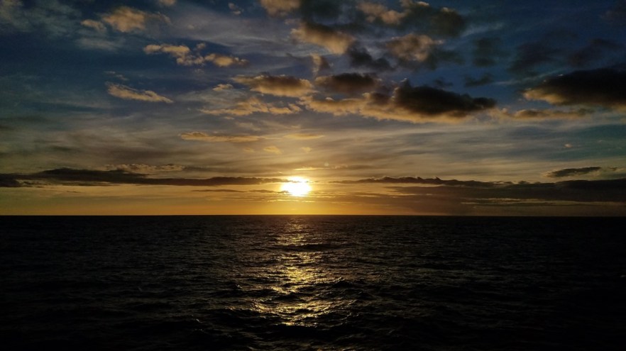
We expected to set sail at 18:00, but the winds were too strong and the harbor was closed. We were cleared to depart about 20:00, during dinner. Along the Beagle Channel we got to see a beautiful sunset followed by a crystal clear night where the band of the Milky Way could be seen with the naked eye while standing on the deck. I tried to get a picture, but the moving of the ship and the long exposure time needed did not allow for a good shot.
Day 3 – Drake Passage
For those that don’t know, the Drake Passage is considered one of the roughest (if not the roughest) areas of water to cross in the world. The Drake Passage stretches for just under 1,000 km (620 mi) and is the spot where the Atlantic, Pacific, and Southern Seas converge, creating a raging and turbulent sea that has the potential to make you regret paying all that money to go to Antarctica. What makes the Drake Passage so infamously rough is the fact that currents at this latitude meet no resistance from any landmass, anywhere on the planet. Mixed with the high probability for strong winds, a crossing of the Drake Passage can be quite the adventure. Expedition vessels nowadays are equipped with stabilizers to absorb much of the swaying and most Antarctica cruise ship passengers are spared the nauseating crossings of the past. The passage’s unpredictability means that it can, at times, be very calm. Whether you experience the Drake Shake or Drake Lake, you can trust a Drake Passage crossing to be a highlight of you cruise to Antarctica. The chances of seeing wildlife while crossing the Drake are high, with whales and migrating albatross making regular appearances.
Luckily for us, the Drake was not in a bad mood. It certainly wasn’t the Drake Lake, but our max roll was about 20° (27° on the way back). While this may not sound like a lot, for 138 cruisers that don’t have their sea legs, our first full day on the ship in rough seas was quite entertaining to watch as people struggled to move about the ship. A large number of passengers decided it would be better to just stay in bed and ride out the crossing. Our beds were nicely positioned port – starboard rather than fore – aft, which really helped with the rolling of the ship. Our bodies were able to take the roll head to toe rather than literally rolling against a wall and possibly out of bed.
The staff held some lectures and surveys during the day, had a briefing of the day and plans for Day 4, and after dinner, the staff musician played in the bar during the evening.
Day 4 – Drake Passage / South Shetlands
Day 4 was more of the same as we worked our way closer to Antarctica. After breakfast, we had a Mandatory IAATO (International Association Antarctica Tour Operators) & Zodiac Briefing to learn about the regulations we were required to observe when conducting landings in Antarctica and the Zodiac procedures. We found out that we had made good progress across the Drake and that we would get to try a landing that afternoon. The biggest hurdles to all landings in Antarctica are the weather and the wildlife.
We signed up for our Mud Room Group, which helped alleviate the number of people getting ready at a time in the Mud Room. After signing up, we all, by group, gathered our outer layers (waterproof pants, gloves, hats, etc.), backpacks, camera bags, tripods, monopods, and walking sticks, and took them to the staff for Biosecurity Inspection. We had to empty and check all hoods, cuffs, seams, pockets, and Velcro for seeds and plant matter, and bring all of the gear you intend to wear in Antarctica for inspection. We did not need to bring any new items that we had not yet worn, like our new Expedition Parkas. The staff inspected these items and vacuumed all velcro and cuffs to ensure no biological contaminants from outside Antarctica are brought onto the land. We also had to dip our boots, tri/mono pods, and walking sticks in an anti-bacterial solution each time we left and returned to the ship to ensure no contamination from place to place.
After lunch, we were informed that we would be arriving at our first stop, Fort Point in the Shetland Islands. Fort Point is a conspicuous rocky point rising to 85 m (279 ft) and linked by a low 700 m (0.44 mi) isthmus to the Southeast coast of Greenwich Island in the South Shetland Islands, Antarctica. We were unable to make a landing as there were far too many seals on the beach (see picture below), so we went on a Zodiac cruise along the coast to check out the animals.
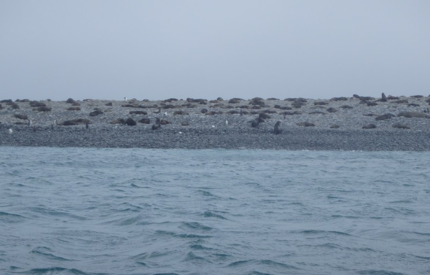
Photo by Cristina Carretero
Day 5 – Cuverville Island / Damoy Point
Cuverville Island lies in the Errera Channel, between Rongé Island and the Arctowski Peninsula. The island was discovered by Gerlache’s Belgica expedition of 1897-1899, and named after a vice-admiral in the French Navy. This small rocky island has vertical cliffs measuring 200 m (650 ft) in elevation with extensive moss cover. Cuverville Island is home to the largest Gentoo Penguin colony in the region (4,800 breeding pairs), along with Southern Giant Petrels, Kelp Gulls, Antarctic Terns, Snowy Sheathbills, and South Polar Skuas.
Cuverville Island was our first shore landing and we were able to get up close to the numerous Gentoo Penguins roaming the land. As a rule, we were instructed to not approach closer than 5 m (15 ft) to penguins and 15 m (50 ft) to seals. If the animal approached us, it was OK to stay still and let them approach, but we should not try to get closer to them. The penguins were not scared of the people, nor did they really care that we were there, unless a human approached them too quickly or blocked their path (also not supposed to do).
Damoy Point lies at the Northern entrance to Port Lockroy, on the West side of Wiencke Island in the Palmer Archipelago. There are two huts at this location: a maintained British refuge hut and an Argentinian hut. The British hut was previously used as a transit station for personnel and supplies to be taken from the ship and flown South in early summer when sea ice blocked access to Rothera (Station R). It was used intermittently between 1973 and 1993 and cleaned up in 1996 – 1997. A Gentoo Penguin colony of approximately 1,600 breeding pairs can be found nearby, between Damoy Point and Dorian Bay.
Damoy Point is also where we went camping for the night. This was our first chance, and the weather wasn’t great with overcast skies and periodic frozen rain (ice pieces, not water) tapping on the roof of the tent all night. To me, I would have opted for another night in hopes of better weather, but the staff saw that the night was not going to be too bad and decided to go for it in case we did not get another chance during the trip. Many of the campers were hoping for clear skies to take time-lapse photos of the Antarctic sky, but we were all disappointed by the relentless clouds. I still took time-lapse photos all night in case it opened up, but it didn’t.
For more pictures, check out my album on Facebook.
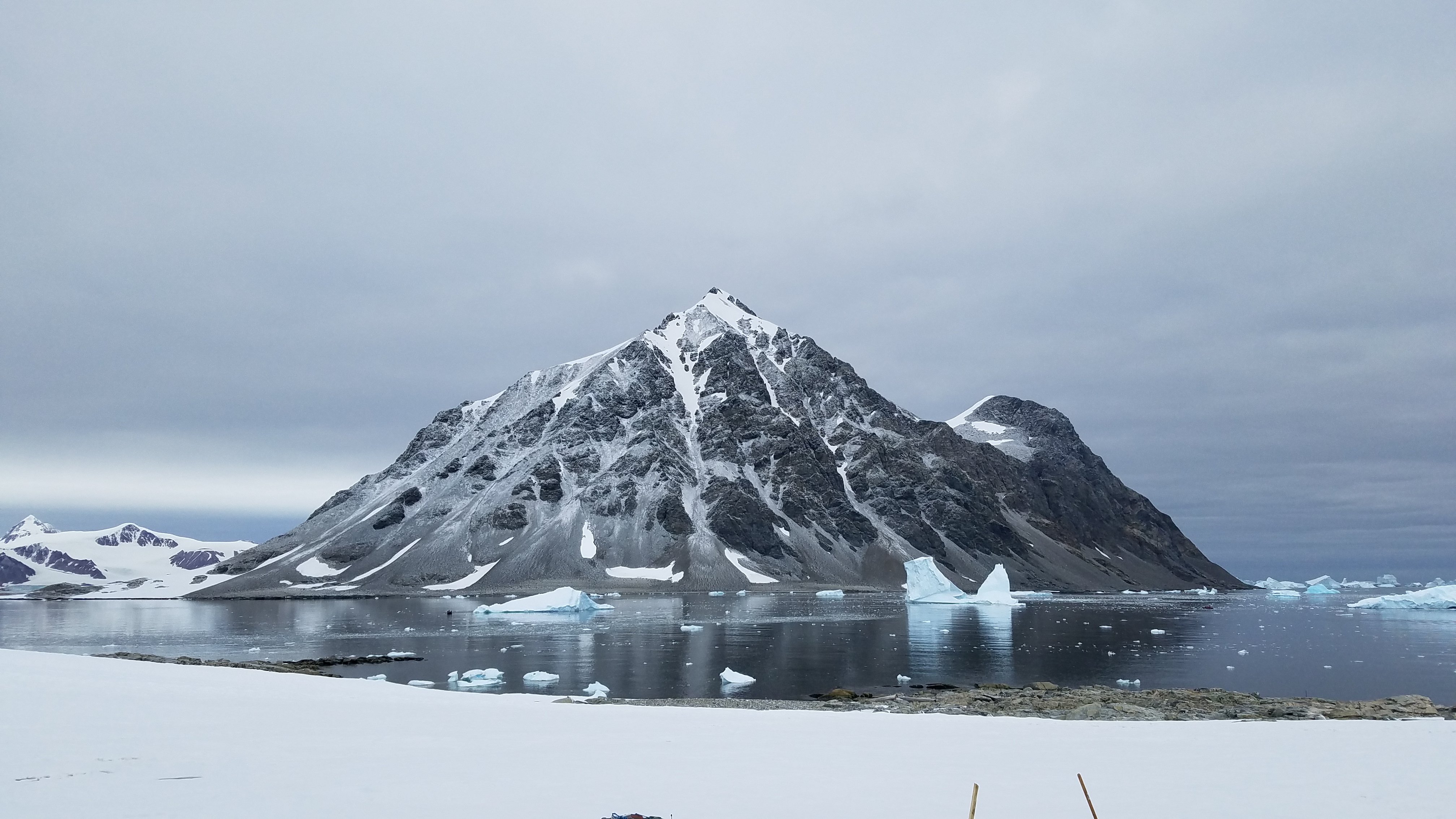
Day 6 – Lemaire Channel, Port Charcot, and Beascochea Bay
The Lemaire Channel is an 11 km (6.8 mi) long by 1.6 km (1 mi) wide passage that runs from False Cape Renard to Cape Cloos, separating Booth Island from the Antarctic continent. It was discovered by Dallmann’s German expedition of 1873 but Gerlache was the first to navigate the channel in 1898 and named it in honor of Charles Lemaire, a Belgian explorer of the Congo. At its narrowest, the Lemaire Channel is less than 800 m (0.5 mi) wide with towering peaks in excess of 300 m (985 ft) overhead. The channel can be full of icebergs and sea ice which makes maneuvering difficult. However, this is a good location for seeing Crabeater Seals, Weddell Seals, and Leopard Seals on ice floes and Minke Whales in transit.
Port Charcot is a 2.4 km (1.5 mi) wide bay at the North of Booth Island, an 8 km (5 mi) long Y-shaped island forming the Western side of the Lemaire Channel. This bay lies on the Northwestern arm of the “Y” shore of Booth Island. From the Southern beach of the NW arm (Salpêtrière Bay) the site rises through a gentle slope leading to the North to a 50 m (165 ft) hill where remains of the Charcot’s expedition can be found. On the Northern shore there is a small cobbled bay, Français Cove, on the North shore sheltered by two small offshore rocky islets and a series of rocky outcrops surround the bay.
Beascochea Bay is a 19 km (11.8 mi) long and 9 km (5.6 mi) wide bay, indenting the Graham Coast of Graham Land, Antarctica, between Kiev Peninsula and Barison Peninsula, and entered South of Cape Perez. The glaciers Lever, Funk, Cadman, Talev, and Butamya feed the bay. It was discovered, but incompletely defined by the Belgian Antarctic Expedition of 1897 – 1899, was resighted by the French Antarctic Expedition in 1903 – 1905, and named by Jean-Baptiste Charcot for Commander Beascochea of the Argentine Navy. The bay was then more accurately charted by the British Graham Land Expedition of 1934 – 1937.
Adie’s Cove is names after Susan Adie, a G Adventures Expedition leader who is descended from Alexander Lange, who led the very first whaling expedition to Antarctica in the early 20th century. In 1960 the U.K. Antarctic Place Names Committee recognized Lange’s expedition leadership by naming a glacier just off the Shetland Islands, Lange Glacier, after him. Lange’s purpose of travel, whaling, is significantly different from Adie’s, which is to encourage sustainable travel and teach conservation aboard G’s Expedition ship. But the parallels between her life and that of her great-grandfather are nonetheless striking. Adie’s Cove is a small cove on the continent’s Western coast, on the Northern shore of Beascochea Bay. The cove was named after Adie in 2016, in recognition of her work as a polar conservationist. We were the first G Expedition tour to actually sail into Adie’s Cove.
Some of the most beautiful scenery on the cruise was while sailing through the Lemaire Channel and Beascochea Bay. The pictures below show just some of the insane scenery that we encountered.
For more pictures, check out my album with Lemaire Channel and album with Port Charcot, Beascochea Bay, and Adie’s Cove on Facebook.
Day 7 – Prospect Point and Crystal Sound
Prospect Point is located at Ferin Head, Graham Coast. The British Antarctic Survey Station J (Known as Graham Coast until 1959) which purpose had been geology & survey had been established there. The Base was occupied February 2, 1957 – February 23, 1959 and closed when local work completed. Removed during March – April 2004, letter J was originally intended for a station on Alexander Island in the 1948 – 1949 season which was never established.
Prospect Point was our first landing on the actual continent of Antarctica (as opposed to the islands along the coast). There could not have been a better morning for it than we had. The sun was shining, the clouds made a crazy pattern in the sky, and the water was smooth. On land, we were able to see Adélie Penguins and the remains of seals that were butchered in 1959. The skins and remains have since been mummified in the Antarctic air. After walking around on land, we took a Zodiac tour around the large blue icebergs. From here, you get a good sense of the scale of Antarctica. The ship disappeared in vastness of the mountains, glaciers, and icebergs. In the pictures below, there is one where I ask if you can see the ship. The ship is just a little dot in the center, right of the mountain and just left of the large, tabular iceberg.
The Fish Islands are located West of Prospect Point, off the Western extremity of Graham Land. Individual islands are named after different fish species, for example, Flounder Island and the islets known as The Minnows. The islands are low-lying and occupied by Adélie penguins with 4,000 breeding pairs estimated in total between 12 colonies. Blue-Eyed Shags also breed on the islands. This area is known for its stunning glacial scenery and tabular icebergs derived from ice shelves further South in the Bellingshausen Sea.
Crystal Sound is between the Southern part of the Biscoe Islands and the coast of Graham Land. It was so named by the UK Antarctic Place-Names Committee in 1960 because many features in the sound are named for men who have undertaken research on the structure of ice crystals. To the North of Crystal Sound, many geographical features are named after physiologists.
The Antarctic Circle is one of the five major circles (or parallels) of latitude that mark maps of the earth. Every place South of the Antarctic Circle experiences a period of twenty-four hours of continuous daylight at least once per year, and a period of twenty-four hours of continuous night-time at least once per year. That is to say, there is at least one whole day during which the sun does not set, and at least one whole day during which the sun does not rise. On the Antarctic Circle these events occur, in principle, exactly once per year, at the December and June solstices respectively. This happens because the earth’s axis is tilted, by approximately 23.5 degrees, relative to ecliptic (the plane of the earth’s orbit around the sun). At the Southern winter solstice, the Southern hemisphere is tilted away from the sun to its maximum extent, and the region of permanent darkness reaches its Northern limit; at the Southern summer solstice, the Southern hemisphere is tilted towards the sun to its maximum extent, and the region of permanent sunlight reaches its Northern limit.
At 17:48 on Monday, February 26, 2018, we crossed the Antarctic Circle at 66.55694444° S 67.13750000° W 3 times (2 South and 1 North) as we did an S-pattern along the circle while everyone celebrated.
For more pictures, check out my album on Facebook.
Day 8 – Detaille Island and The Gullet
Detaille Island lies in Lallemand Fjord off Crystal Sound, on the Loubet Coast, East of Adelaide Island. The hut at this site is the British Antarctic Survey’s Station W, which was evacuated in 1959 when sea ice and weather made relief by ship impossible. At this time, base personnel closed the station and transferred to Station Y at Horseshoe Island. Research undertaken at Detaille Island site had focused on surveying, geology and meteorology. The hut was cleaned up by BAS in 1996 – 1997.
Sea Ice arises as seawater freezes. Because ice is less dense than water, it floats on the ocean’s surface. Sea ice covers about 7% of the Earth’s surface and about 12% of the world’s oceans. Much of the world’s sea ice is enclosed within the polar ice packs in the Earth’s polar regions: the Arctic ice pack of the Arctic Ocean and the Antarctic ice pack of the Southern Ocean. Polar packs undergo a significant yearly cycling in surface extent. The Antarctic sea ice cover is expanding to an area roughly equal to that of Antarctica in winter. While the Antarctic sea ice yearly wintertime maximum extent hit record highs from 2012 to 2014 before returning to average levels in 2015, both the Arctic wintertime maximum and its summer minimum extent have been in a sharp decline for the past decades. Studies show that globally, the decreases in Arctic sea ice far exceed the increases in Antarctic sea ice.
The Gullet is a narrow channel between the eastern extremity of Adelaide Island and the west coast of Graham Land, Antarctica, separating Hansen Island and Day Island and connecting the heads of Hanusse Bay and Laubeuf Fjord. This area was first explored in 1909 by the French Antarctic Expedition under Jean-Baptiste Charcot who, though uncertain of the existence of the channel, sketched its probable position on the charts of the expedition. The channel was first visited and roughly surveyed in 1936 by the British Graham Land Expedition under John Rymill. It was resurveyed and given this descriptive name in 1948 by members of the Falkland Islands Dependencies Survey.
We were the first ship to transit The Gullet in 7 YEARS (since the 2010/2011 season)!!
Here’s a time-lapse video of approaching The Gullet. This time-lapse was filmed by Vhina Donan, a fellow passenger on the trip, who shared her video with the other passengers.
These are videos by me of us breaking through some of that ice:
For more pictures, check out my album for Crystal Sound and Detaille Island and my album for The Gullet on Facebook.
Day 9 – Stonington Island, and Horseshoe Island
Stonington Island lies in Marguerite Bay, South of Adelaide Island. It is named for Stonington Connecticut, the home port of American sealing captain Nathanial Brown Palmer’s sloop Hero. There are two historic huts on shore at this site. The first is the British Antarctic Survey’s Stonington Base or Station E. Stonington was occupied by 6-17 men between 1946-50, 1958-59 and 1960-75. This station, however, is famous for its epic surveying work carried out between 1947 and 1950. During this period, surveying work was conducted with dog sled teams, where personnel remained in the field for several months at a time, covering vast areas of land. Sir Vivian Fuchs, the famous polar explorer, was also the Base Commander between 1948 and 1949. Later on, research conducted from Stonington focused more on geology, meteorology and biology. The station was closed in 1950 as ships could not access the site in 1949 due to sea ice conditions, however, it was reopened in 1960 when Horseshoe Island (Station Y) was closed. Two graves of station personnel are located on Flagstaff Hill.
The second hut is the US’ East Base. It is located only 230 m (750 ft) away from Stonington Station. It is the earliest remaining US station in Antarctica. East Base was established in 1940 and later used by the privately funded Ronne Antarctic Research Expedition of 1947 – 1948. Included in the group were the first women to winter in Antarctica, Edith Ronne and Jennie Darlington, who were accompanying their husbands. The two men did not see eye-to-eye and their wives are said to have not spoken to each other, out of loyalty to their husbands. East Base is still relatively intact. The two huts were cleaned-up and repaired by BAS and US parties in 1991 – 1992 and last inspected in 2007.
Since this was the cleanest snow (no penguin guano), a good hill, and the right consistency of snow, Cristina and I decided to slide like penguins! Here’s my slide!
After departing Stonington Island and heading back North, we passed by the point farthest South on our trip at 67.85° S 67.20° W, which is 159.36 km (99.02 mi) South of the Antarctic Circle.
Horseshoe Island lies in Bourgeois Fjord, Marguerite Bay. It was home to the British Antarctic Suvey’s Base Y which operated between 1955 – 1960 and for a brief period in 1969. Fieldwork conducted at this site focused on surveying the local area, geology and meteorology. When the station was closed in 1960, personnel were transferred to Station E on Stonington Island. The station was cleaned up by BAS personnel in 1995.
For more pictures, check out my album on Facebook.
Day 10 – Petermann Island
Petermann Island lies just below the Lemaire Channel, Southwest of Hovgaard Island, in the Wilhelm Archipelago. It was discovered by the Dallman expedition of 1873 – 1874 and named after August Petermann, a German geographer and supporter of polar exploration. The French explorer Jean-Baptiste Charcot and his vessel Pourquoi Poi? (meaning ‘why not?’) overwintered here in 1909. Charcot also named a cove on the Southwest side of the island Port Circumcision because he discovered it on Circumcision Day. On the beach near the cove is an abandoned Argentinean refuge hut, built in 1955. There is also a memorial cross nearby for three British scientists who died near here in August 1982. Petermann Island is home to Adélie penguins (approx. 500 breeding pairs), the most Southerly colony of Gentoo penguins in Antarctica (approx. 2,000 breeding pairs) and Blue-Eyed Shags. Grass and moss can also be found on the Northern section of the island once snow melts. There are stunning views from Petermann Island both looking North towards the Lemaire Channel and South to the mountainous landscape of Graham Land.
That evening we were treated to a concert in the bar from The Monkey Eating Eagles band. The Monkey Eating Eagles is the crew band and the former name for the Philippine National Symbol, the now endangered Philippine Eagle. They are dedicated to having fun, bring fun to the guests, and help to raise funds to help save the King of the Forest. They play once a voyage in the Polar Bear Pub. They are the Farthest North Band or Farthest South Band, depending on which part of the world the ship is in at the time.
For more pictures, check out my album on Facebook.
Day 11 – Deception Island and Hannah Point
Deception Island rises 500 m (1,640 ft) from the seabed and has a submerged basal diameter of 25 km (25.5 mi). It was formed by a big collapse, due to an eruption of an unknown age. At least 85% of this island was formed by volcanism prior to the collapse. These older deposits are mainly composed of yellow tuff. The only sea access into and out of the caldera is through a narrow space called Neptune’s Bellows. The last eruption was in 1969 and has left the glaciers paritally covered in black ash, which makes for the appearance of black glaciers.
We hoped to do the Polar Plunge here because of the normally protected bay, plus the warm sand from geothermal activity, but the wind was too high for the ship to anchor and for us to safely take the Zodiacs to the old whaling station in Whaler’s Bay.
Hannah Point lies in Walker Bay on the Southern coast of Livingston Island. It is named after a sealing vessel that was shipwrecked at this site in 1820. Hannah Point is renowned for its abundant wildlife. This includes Chinstrap penguins (approx. 1,500 breeding pairs), Gentoo penguins (approx. 1,000 breeding pairs) and the occasional Macaroni penguin, along with Blue-Eyed Shags, Snowy Sheathbills, Kelp Gulls, Pintados, Skuas, and Southern Giant Petrels. An Elephant Seal wallow is located near the Gentoo penguin colony while a small collection of fossil plants can be found at the base of Walker Bay. Antarctica’s two species of flowering plant Deschampsia Antarctica and Colobanthus Quitensis are also present at this site.
Since we didn’t get to do the Polar Plunge at Deception Island, our last chance was here at Hannah Point. The weather was beautiful, the water was calm, so the crew decided this would be the spot. Over half of the passengers braved the 1° C (33.8° F) water to say we did the Polar Plunge in Antarctica. I was definitely one of those crazy enough to do it and there’s a picture below of me after coming up from under the water.
For more pictures, check out my album on Facebook.
Day 12 – Drake Passage
We’re back in the Drake and headed North to Argentina. More movies and lectures as we are tossed around the sea on our way back to Ushuaia.
Day 13 – Drake Passage, Cape Horn, and Beagle Channel
Waking before sunrise, the captain had a special treat for us since we made such good time on Day 12. We got to sail around Cape Horn! Cape Horn is located on the small Hornos Island and named after the city of Hoorn in the Netherlands. It is the Southernmost headland of the Tierra del Fuego archipelago of Southern Chile. Although not the most Southerly point of South America (which are the Diego Ramirez Islands), Cape Horn marks the Northern boundary of the Drake Passage and the meeting place of the Atlantic and Pacific Oceans. For many years it was a major milestone on the clipper route, by which sailing ships carried trade around the world. However, the waters around the Cape are particularly hazardous, owing to strong winds, large waves, strong currents, and icebergs getting washed up with currents from Antarctica. These dangers have made it notorious as a sailor’s graveyard. The need for ships to round Cape Horn was greatly reduced by the opening of the Panama Canal in 1914. However, sailing around the Horn is widely regarded as one of the major challenges in yachting.
The rest of the day was spent sailing through the Beagle Channel on our way back to Ushuaia, where we arrived just after dinner. We had some lectures and briefings throughout the day, as well as the Captain’s Farewell, Expedition Recap, Auction, Raffle, and Slideshow. Once we were docked, we were allowed to get off the ship if we wanted as long as we were back in the morning for the disembarkation procedure, which some of us took full advantage of after a rough night on the Drake. I almost slide out of my bed feet first sometime between 03:00 and 04:00!
For more pictures, check out my album on Facebook.
Sunrise from Cape Horn
Day 14 – Departure Day
Everyone said their goodbyes and headed off the ship to various destinations.
How does one accurately describe this virtually unspoiled wilderness? It is the only continent that doesn’t belong to anyone, is protected from humans, is protected by both humans and nature, and it is truly breathtaking. The unique geological location of the continent provides a protective polar current of both weather and sea to keep it how it is. Maybe it’s so far away, so hard to get to, and has no indigenous human life for a reason, because nature decided we don’t need to be there.
I hope this post gives you some inspiration to help keep Antarctica unspoiled and pure. I’d like to recommend going there, but honestly, I think humans should leave it alone and let it be pure and unspoiled. Antarctica should be left to a very small number of scientists doing legitimate scientific research to ensure that the rest of the world doesn’t screw up the last remaining true example of unspoiled nature on the planet.
If you’re interested in visiting Antarctica, please do so responsibly. Use a reputable travel company, follow the rules, respect the wildlife, respect nature, and do your best to keep it natural and unspoiled. For a list of responsible Antarctic travel companies, please visit the IAATO (International Association Antarctica Tour Operators) website. I really enjoyed traveling with G Adventures, not only on this trip, but others as well, because they truly care about the world in which we live and through their Planeterra Foundation are doing their best to make the world a better place for all. If you are fortunate enough to see Antarctica, when you return from the experience, tell your friends and family what you’ve seen and learned.
For photos from the entire trip, check out all my albums on Facebook and my YouTube channel.
Please share with your friends using the links below. If you have any questions or comments, please reply using the box below.
Thanks for reading!

Thank you for your informative post. Where did you get the Antarctica passport stamp?
LikeLiked by 1 person
Jannah, forgive me if I have not replied before now. I thought I had, but I don’t see my reply.
There were 2 locations for the stamps, the 2 smaller stamps of Antarctica and the one with the Penguin came from the Centro de Información Turística in Ushuaia (http://turismoushuaia.com/). The other stamp came from the post office on Stonington Island, down in the Antarctic Peninsula.
LikeLike